
Fietsgids River Rhone Cycle Route - Cicerone
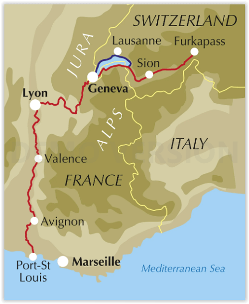
Furkapass - Genève - Lyon - Valence - Avignon - Port-St Louis
Korte omschrijving
Fietsgidsen Wallis, Zwitserland van CICERONE Press. Ideaal voor tochten in Frankrijk.
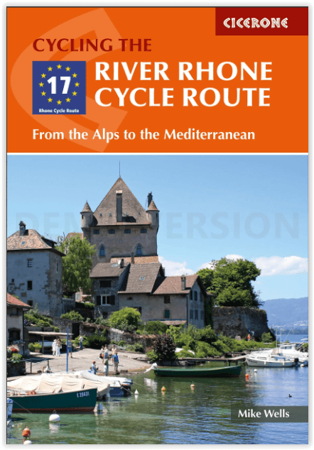
River Rhone Cycle Route - Cicerone Productomschrijving: 895 km in 20 etappes - Deze gids omvat de fietsroute van de Rhône, een 895 km lange rit door Frankrijk en Zwitserland van de Zwitserse...

Specificaties
- Uitgever: CICERONE Press
- ISBN-13: 9781786310828
- HOOFDCATEGORIEËN: Fietsgids
- Activiteiten: Fietsen / VTT / MTB
- Auteur: Mike Wells
- Regio: Wallis, Zwitserland
- Land: Frankrijk
- Departement: Ardèche (07), Drôme (26), Gard (30), Isère (38), Jura (39), Savoie (73), Saône-et-Loire (71)
- Editie: 2
- Taal: Engels
Volledige omschrijving
River Rhone Cycle Route - Cicerone
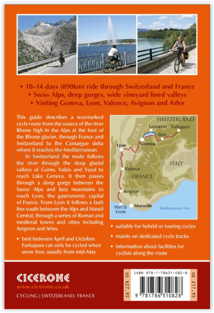
Productomschrijving: 895 km in 20 etappes - Deze gids omvat de fietsroute van de Rhône, een 895 km lange rit door Frankrijk en Zwitserland van de Zwitserse Alpen naar de Middellandse Zee. Verdeeld in 20 etappes, elk ongeveer 45 km lang, kan de route door de meeste fietsers in 10-14 dagen worden afgelegd. Inclusief informatie over voorbereiding, navigatie, accommodatie en voorzieningen onderweg.
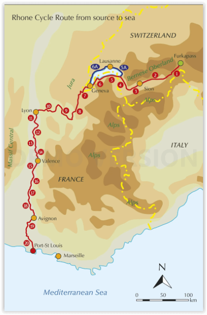
Moet je zeker gezien hebben: The Rhone glacier, Furka pass, Lake Geneva, Château de Chillon, Montreux, Lausanne, Geneva, Lyon, Vienne, Valence, Montélimar, vineyards of the Côtes du Rhone, papal city of Avignon. Roman Arles, Camargue delta.
Engelse omschrijving: Guidebook to cycling the Rhone Cycle Route, an 895 km ride through France and Switzerland from the Swiss Alps to the Mediterranean Sea. Divided into 20 stages, each approximately 45km long, the route can be completed by most cyclists in 10-14 days. Includes information on preparation, navigation, accommodation and amenities on route.
Seasons:
Except for stage 1 in the high Swiss Alps, the route can be cycled between April and October. Stage 1 can only be cycled when Furkapass is snow free, usually mid-May to mid-October.
Centres:
A point-to-point route passing through Martigny, Montreax, Geneva, Lyon, Vienne, Valence, Montélimar and Arles.
Difficulty:
A straightforward route that is generally downhill or level, (though there are a few short ascents). Mostly asphalt surfaces in good condition suitable for hybrid or touring cycles. Much of the route follows dedicated off-road cycle tracks, suitable for family cycling, though there are a few short sections where main roads are used.
Artikelen uit dezelfde regio
Wandelgids Bahnwanderweg Loetschberg - Rotpunkt Verlag • 9783858693839
Bahnwanderweg Loetschberg - Rotpunkt Verlag Productomschrijving: Bahnwanderweg Lötschberg, is een Duitstalige wandelgids voor wie de historische Lötschbergroute te voet wil ontdekken. De gids beschrijft een meerdaagse wandelroute in 10 etappes van Frutigen naar Brig, langs een van de bekendste spoortrajecten van Zwitserland. Daarmee combineert dit boek wandelen, spoorweggeschiedenis, bergl…
Wandelkaart 1325 Sembrancher Wallis - Swisstopo • 9783302013251
Wandelkaart Sembrancher - Wallis Zwitserland - Swisstopo Productomschrijving: Kaart 1325 - Net buiten Martingy gelen langs de E27 weg tussen moiyn gebergtes, ligt dit dorp tussen de bossen. Detail: Zeer gedetailleerde topografische kaarten & wandelkaarten van een klein stuke Zwitserland met schaal 1:25.000.en nr 1011 > 1374. De topografische details van deze kaarten zijn onmetelijk goe…


Wandelkaart 1268 Lotschental Berner Oberland - Swisstopo • 9783302012681
Wandelkaart Lotschental - Berner Oberland - Swisstopo Productomschrijving: Kaart 1268 - Gelegen in een zeer bergachtig gebiedt, In de directe omgeving van het Naturpark Pfyn-Finges, net onder de Bietschhorn. Detail: Zeer gedetailleerde topografische kaarten & wandelkaarten van een klein stuke Zwitserland met schaal 1:25.000.en nr 1011 > 1374. De topografische details van deze kaarten z…
Fietsen door de Alpen en Piemonte naar de zee - Benjaminse • 9789077899359
Fietsen door de Alpen en Piemonte naar de zee - Benjaminse Productomschrijving: Fietsroute Door de Alpen en Piemonte naar de Zee Aantal detailkaarten: 67, schaal 1:100.000 Aantal stadskaarten: 6, schaal varieert Afstand: 775 km + 170 km langs Italiaanse Meren + 125 km via Turijn Moeilijkheidsgraad: Gemiddeld, voor de echte zwaardere beklimmingen zoals de Simplonpas, kan men ee…

Wandelkaart 271 Chablais Wallis Zwitserland - Swisstopo • 9783302002712
Wandelkaart Chablais - Wallis Zwitserland - Swisstopo Omvat: Sciez, Morzine & Les Cornettes de Bise Productomschrijving: Chalais is een gemeente en plaats in het Zwitserse kanton Wallis, en maakt deel uit van het district Sierre. Detail: Zeer gedetailleerde topografische wandelkaarten van een klein stuke Zwitserland met schaal 1:50.000. De topografische details van deze kaarten zij…