

Wandelgids The Dales Way - Trailblazer
Ilkley in the Yorkshire Dales NP tot Bowness-on-Windermere 130 km

Korte omschrijving
Wandelgidsen Yorkshire, England van Trailblazer Publications. Ideaal voor tochten in England.
Wandelgids The Dales Way - Trailblazer Publications Productomschrijving: Dales Way: Ilkley to Bowness-on-Windermere - Het langeafstandswandelpad Dales Way begint in Ilkley, in het Yorkshire ...

Specificaties
- Uitgever: Trailblazer Publications
- ISBN-13: 9781912716302
- HOOFDCATEGORIEËN: Wandelgids
- Activiteiten: Wandelen, Hiking & Trekking
- Auteur: Henry Stedman
- Regio: Yorkshire, England
- Land: England
- Lange afstand wandelroutes: The Dales Way (130 km)
- Editie: 2
- Taal: Engels
Volledige omschrijving
Wandelgids The Dales Way - Trailblazer Publications
Productomschrijving: Dales Way: Ilkley to Bowness-on-Windermere - Het langeafstandswandelpad Dales Way begint in Ilkley, in het Yorkshire Dales National Park en loopt over 81 mijl (130 km) om te eindigen in het Lake District, in Bowness-on-Windermere. Het volgt de prachtige rivier de Wharf richting Ribblehead, meandert dan langs de riviervalleien van Dentdale en daalt uiteindelijk af in het Lake District National Park om te eindigen bij Lake Windermere. Het is een relatief gemakkelijke wandeling die ongeveer een week duurt. Er wordt ook informatie gegeven over verbindingsroutes vanuit Harrogate, Bradford en Leeds.
Engelse omschrijving: Dales Way: Ilkley to Bowness-on-Windermere - The Dales Way long-distance footpath begins in Ilkley, in the Yorkshire Dales National Park and runs for 81 miles (130km) to end in the Lake District, at Bowness-on-Windermere. It follows the beautiful River Wharf towards Ribblehead, then meanders along the river valleys of Dentdale, eventually dropping down into the Lake District National Park to finish near Lake Windermere. It’s a relatively easy walk that takes about a week. Information about link routes from Harrogate, Bradford and Leeds is also given.
- The largest scale walking maps available- Downloadable GPS waypoints also included.
- Itineraries for all walkers
- All-in-one-guide
- Comprehensive public transport information for weekend and day walks - (British Walking Guide) - 38 detailed walking maps
- 23 town and village guides
- 30 colour photos & colour flower and bird sections
- 120mm x 180mm, 5" x7"

Artikelen uit dezelfde regio

Fietskaart Yorkshire Dales - Harvey maps • 9781851374014
Fietskaart Yorkshire Dales - Harvey maps Productomschrijving: 8 ritten in de Yorkshire Dales variërend in lengte van 11 tot 23 mijl. Bevat gedetailleerde kaarten en geschreven routebeschrijving. Informatie over lokale punten van belang en sites om te bezoeken. Telefoonnummers van toeristische informatiecentra en andere nuttige contacten. Nieuwe generatie HARVEY Superwalker, XT25 water…
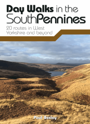
Wandelgids Day Walks in the Southern Pennines - Vertebrate Publ. • 9781912560653
Day Walks in the Southern Pennines - Vertebrate Productomschrijving: 20 routes in West Yorkshire and beyond Day Walks in the South Pennines features 20 circular walks between 5 and 18 miles (8km and 29 km) in length, spread across West Yorkshire, Lancashire and Greater Manchester. Researched and written by knowledgeable and experienced author Paul Besley, the walks range from gentle r…

Trailrunning gids Yorkshire Dales NP - Cicerone • 9781852849221
Trailrunning gids, 40 runs in the National Park-Three Peaks Productomschrijving: Guidebook to 40 great trail and fell runs in the Yorkshire Dales National Park. Ranging from 5 to 24 miles, the graded runs start from bases such as Hawes, Settle, Ingleton, Dent, Sedbergh, Malham and Grassington and take in the region's diverse delights, from castles and waterfalls to iconic mountains such a…

Reisgids Walking the Wharfe - Bradt travel Guides • 9781804691106
Walking the Wharfe - Bradt travel Guides Productomschrijving: In een wereld van globetrottende ontdekkingsreizigers en recordbrekende reizen - waar hij zelf ook deel van uitmaakte - besloot Johno Ellison terug te keren naar zijn roots en de hele lengte van de rivier Wharfe te lopen, de waterweg in Yorkshire waar hij opgroeide. In zijn nieuwe boek voor Bradt, Walking the Wharfe, volgt Ellis…

Wandelkaart The Dales Way Yorkshire - Harvey maps • 9781851374281
Wandelkaart The Dales Way Yorkshire - Harvey maps Productomschrijving: Toont de gehele 130km (81 mijl) van The Dales Way van Ilkley in Yorkshire door de Dales via Grassington, Dent en Buckden naar Bowness on Windermere in het Lake District. Bevat alle 3 links: van Leeds, Shipley (Bradford) en Harrogate. Met informatie over het vinden van accommodatie, camping, voedsel. Tevens is de routebe…