

Wandelgids Part 3 SWCP Map Booklet PLymouth to pool - Cicerone
Van Plymouth naar Poole langs de kustlijn van Devon en Dorset


Korte omschrijving
Wandelgidsen South West England, Devon, England en Dorset, England van CICERONE Press. Ideaal voor tochten in United Kingdom, Great Britain.
Map booklet South West Coast Path - Cicerone Productomschrijving: Kaart van een deel van het zuidelijke deel van het 630 mijl (1014 km) lange South West Coast Path National Trail. Omvat het ...

Specificaties
- Uitgever: CICERONE Press
- ISBN-13: 9781786312006
- HOOFDCATEGORIEËN: Wandelgids
- Activiteiten: Wandelen, Hiking & Trekking
- Regio: Devon, England, Dorset, England, South West England
- Land: United Kingdom, Great Britain
- Schaal: 1:25000
- Editie: 2
- Taal: Engels
- Reeks/Serie: Map Booklet, Cicerone
- Iconische Wandelroutes: South West coast Path, Cornwall UK
Volledige omschrijving
Map booklet South West Coast Path - Cicerone
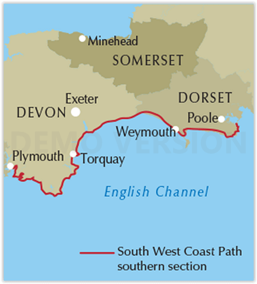
Productomschrijving: Kaart van een deel van het zuidelijke deel van het 630 mijl (1014 km) lange South West Coast Path National Trail. Omvat het pad van Plymouth naar Poole langs de kustlijn van Devon en Dorset. Dit handige en compacte boekje met Ordnance Survey 1:25.000 kaarten toont de route en biedt alle kaarten die je nodig hebt om het pad in beide richtingen te lopen.
Engelse omschrijving: Map of part of the southern section of the 630 mile (1014km) South West Coast Path National Trail. Covers the trail from Plymouth to Poole along the coastline of Devon and Dorset. This convenient and compact booklet of Ordnance Survey 1:25,000 maps shows the route, providing all of the mapping you need to walk the trail in either direction.
Seasons:
This National Trail may be walked year-round: be aware that winter accommodation availability may be limited, while high summer will be extremely busy and the weather often hot.
Centres:
Many centres are passed along the route, including Plymouth, Salcombe, Brixham, Weymouth, Swanage and Poole.
Difficulty:
The South West Coast path is a long walk! Most paths are easy to moderate, with some walks along rugged and exposed coastal cliff paths and some steep gradients.
Must See:
Exmoor National Park, Areas of Outstanding Natural Beauty, numerous Heritage Coasts, National and Local Nature Reserves, Sites of Special Scientific Interest and National Trust holdings.
Artikelen uit dezelfde regio
Wandelgids Great Walks on the England Coast Path - Cicerone • 9781852849894
Great Walks on the England Coast Path - Cicerone Engelse omschrijving: At around 4500 km (2800 miles), the England Coast Path is the longest coastal trail in the world. This inspirational large-format guide presents a handpicked selection of 30 highlight sections, offering a taste of England's stunning and diverse shoreline. Routes range from 9 to 45km, spanning between 3 hours and 2 days,…

Wandelkaart 117 Cerne Abbas & Bere Regis - Dorset - OSI • 9780319243183
Wandelkaart Cerne Abbas & Bere Regis - Dorset - OSI Productomschrijving: - Blandford Forum & Beaminster. 117 / Cerne Abbas & Bere Regis, Dorset AONB, England - Neem in Bere Regis, Blanford Forum, Cerne Abbas en Beaminster, Dorset word met deze kaart aangemerkt als een gebied van uitstekende natuurlijke Beaurty AONB. Hij heeft ook betrekking op delen van sommige populaire recreatieve pa…

Wandelgids SWCP part 3 - Dorset & South Devon - Trailblazer • 9781912716340
Wandelgids SWCP part 3 - Dorset & South Devon - Trailblazer Productomschrijving: Dorset & South Devon Coast Path (South-West Coast Path Part 3) This guide covers the third and last section of the South West Coast Path, from Plymouth to Poole Harbour (217 miles). This beautiful route includes 95 miles within England’s only Natural World Heritage Site, the Jurassic Coast, and passes dram…

Reisgids Devon & Cornwall - Rough Guides • 9780241270325
Reisgids Devon & Cornwall - Rough Guides Productomschrijving: The Rough Guide to Devon and Cornwall is the perfect companion to your trip to this captivating peninsula, introducing you to the charms of gentle, pastoral Devon and wild, craggy Cornwall. Both counties will tempt you outside to enjoy their mild climate, with everything from hikes over Dartmoor and surfing off Newquay to puffi…

Wandelkaart OL9 Exmoor NP- Summerset England - OSI • 9780319469279
Wandelkaart Exmoor NP - Summerset England Omvat ook: Barnstaple, Lynton, Minehead & Dulverton Productbeschrijving: Kaart nummer OL9 in de Explorer kaarten reeks is de perfecte metgezel voor diegenen die de schoonheid willen ervaren van wandelen in het Exmoor Nationale Park. Exmoor Nationaal park heeft 1000 km van wandel- en ruiterpaden, rivieren en een overdekte heidegebied. Wandelaars…