

Wandelgids Lea Valley walk - Cicerone Press
Leagrave to the heart of London - 9 Etappes - 85 Km

Korte omschrijving
Wandelgidsen Bedfordshire, England en Greater London, England van CICERONE Press. Ideaal voor tochten in England.
Wandelgids Lea Valley walk - Cicerone Productomschrijving: Guidebook to the Lea Valley Walk, a 53 mile path from Luton to the Thames. The walk traces the River Lea from Leagrave, near Luton ...

Specificaties
- Uitgever: CICERONE Press
- ISBN-13: 9781786312877
- HOOFDCATEGORIEËN: Wandelgids
- Activiteiten: Wandelen, Hiking & Trekking
- Auteur: Leigh Hatts
- Regio: Bedfordshire, England, Greater London, England
- Land: England
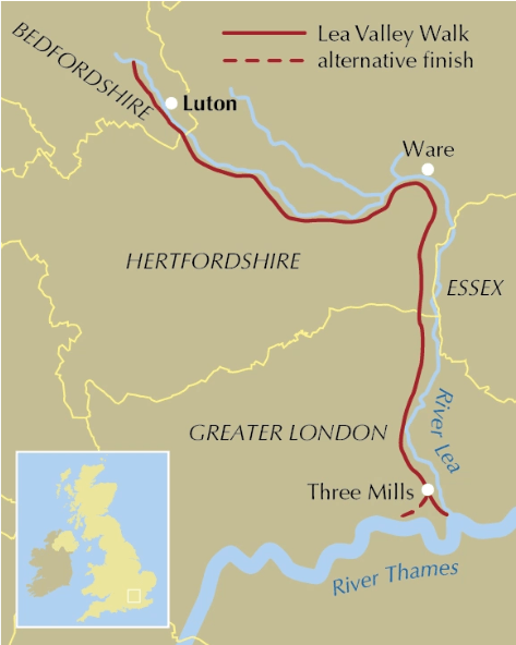
- Lange afstand wandelroutes: Lea Valley walk, Bedfordshire (85 Km) England
- Editie: 4
- Taal: Engels
- De Engelse Graafschappen: Bedfordshire
Volledige omschrijving
Wandelgids Lea Valley walk - Cicerone
Productomschrijving: Guidebook to the Lea Valley Walk, a 53 mile path from Luton to the Thames. The walk traces the River Lea from Leagrave, near Luton to East India Dock opposite Greenwich where it joins the Thames Path. Features an alternative finish at Limehouse and an optional tour of the Olympic Park. Split into 9 stages, the walk is suitable for all abilities.
Seasons:
The Lea Valley walk can be done at any time of the year.
Centres:
Leagrave, Luton, Harpenden, Wheathampstead, Hatfield, Hertford, Ware, Broxbourne, Waltham Abbey, Hackney Marshes, east London, Greenwich.
Difficulty:
None, except general fitness for a mostly flat, low-level, multi-day walk.
Must See:
Surprisingly wild Bedfordshire, Waltham Abbey, the industrial landscape through east London, the Thames itself.
- Presented in stages (13–28km (8-17 miles)) with an alternative finish option (Stage 6).
- Can be completed over a long weekend, over the course of a week, or across multiple weekends.
- A 6km (4-mile) circular walk (Tour of the Olympic Park) is also described.
- 1:50,000 OS maps feature alongside route description.
- Invaluable railway links provided, offering myriad itinerary flexibility.
- Facilities table to help you plan your itinerary.
- GPX files available to download.

Artikelen uit dezelfde regio

Reisgids Cartoville Londres London 2026-27 - Gallimard • 9782742468683
Reisgids Londres London 2026-27 - Gallimard Productomschrijving: De Westminster à Buckingham Palace, de Hyde Park à Greenwich, de la National Gallery à la Tate Modern, de la City à la Tour de Londres, la capitale du Royaume-Uni se déploie en un clin d’œil avec un guide pas comme les autres. • Un concept unique : une carte grand format, dépliable par quartier, pour se repérer immédiatem…

Wandelgids 054 Pathfinder guides Hertfordshire & Bedfordshire- OS • 9780319090077
Wandelgids Hertfordshire & Bedfordshire - OS Productomschrijving: This walkers guide contains 28 outstanding circular walks in Hertfordshire and Bedfordshire ranging from 5.5km to 15km. Each route has easy-to-follow route descriptions, clear Ordnance Survey route maps, GPS waypoints, where to park, good pubs and places of interest en route. All of the routes have been researched and writt…

Wandelgids London to Walsingham Camino - Trailblazer • 9781912716319
Camino London to Walsingham England - Trailblazer Productomschrijving: Camino van Londen naar Walsingham - De pelgrimsgids - Voordat Hendrik VIII in 1538 de bedevaart en de verering van heiligen verbood, was de route van Londen naar het heiligdom van Walsingham in Norfolk de populairste pelgrimstocht in Engeland. Deze gids volgt een nieuw herontdekte route tussen de hoofdstad en het ou…
Wandelgids Walking the Thames Path National Trail - Cicerone • 9781786311481
Thames Path National Trail - Cicerone Productomschrijving: Een gloednieuwe wandelgids vover het Theemspad, een National Trail van 180 mijl tussen de Thames Barrier in Londen en de bron van de rivier in Gloucestershire, door Windsor, Oxford en het platteland. Biedt volledige informatie over deze gemakkelijke route langs de rivier die ongeveer twee weken in beslag neemt. Inclusief een 1:25K …
Wandelgids London LOOP - Trailblazer • 9781912716210
Wandelgids London LOOP - Trailblazer Productomschrijving: De London LOOP - London Outer Orbital Path is een rondwandeling van 150 mijl door de hoofdstad, die begint in Erith en eindigt in Purfleet-on-Thames. Het blijft binnen de M25 en houdt zich grotendeels aan de Metropolitan Green Belt - die bufferzone van groene, grotendeels onontwikkelde grond die de stad omringt. Engelse omschrij…