

Wandelgids Glyndwr's Way walking - Cicerone
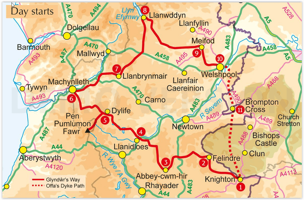
Van Knighton via Machynlleth naar Welshpool - 217 km


Korte omschrijving
Wandelgidsen Wales van CICERONE Press. Ideaal voor tochten in Wales.
Glyndwr's Way walking - Cicerone Productomschrijving: Gids over de hystorische wandelroute van de Glyndwr's Way, een langeafstandspad door midden-Wales. De 217 Km lange route van Knighton vi...

Specificaties
- Uitgever: CICERONE Press
- ISBN-13: 9781786311290
- HOOFDCATEGORIEËN: Wandelgids
- Activiteiten: Wandelen, Hiking & Trekking
- Regio: Wales
- Land: Wales
- Historische wandelroutes: Glyndwr's Way, Wales (217 km)
- Lange afstand wandelroutes: Glyndwr's Way, Wales (217 km)
- Editie: 3
- Taal: Engels
- Reeks/Serie: National Trails, UK
Volledige omschrijving
Glyndwr's Way walking - Cicerone
Productomschrijving: Gids over de hystorische wandelroute van de Glyndwr's Way, een langeafstandspad door midden-Wales. De 217 Km lange route van Knighton via Machynlleth naar Welshpool duurt 9 dagen om te lopen, en 2 dagen (29 mijl) om de lus langs het Offa's Dyke Path af te maken zodat er een rondwandeling ontstaat. Een prachtige route door rustige heuvels, bossen en glooiend landschap.
Engelse omschrijving: Guidebook to walking Glyndwr's Way, a long-distance National Trail through mid-Wales. The 135 mile route from Knighton via Machynlleth to Welshpool takes 9 days to walk, and 2 days (29 miles) to complete the loop down the Offa's Dyke Path to create a circular trail. A lovely trail through quiet hills, forests and rolling countryside.
Seasons:
Spring, summer and autumn are ideal for walking; winter can be a problem if there is deep snow; after prolonged rain some parts can be muddy
Centres:
Knighton, Llangunllo, Felindre, Llanbadarn Fynydd, Abbeycwmhir, Llanidloes, Dylife, Machynlleth, Cemmaes Road, Llanbrynmair, Llangadfan, Llanwddyn, Dolganog, Meifod, Welshpool, Montgomery.
Difficulty:
Suitable mainly for long-distance walkers; essentially hill country, with lots of ascents and descents, but also many gentle and easy stretches; careful attention to waymarking is required and accommodation is sparse in some places.
Must See:
Quiet and remote mid-Wales countryside, links with the Offa's Dyke Path, Abbeycwmhir ruins, Llyn Clywedog, Dylife mines, Parliament House at Machynlleth, Dyfnant Forest, Llyn Efyrnwy, Ann Griffiths Walk, Powis Castle.

Artikelen uit dezelfde regio

Reisgids Great Britain - Rough Guides • 9781835290415
Great Britain reisgids - Rough Guides Productomschrijving: Full-colour throughout, The Rough Guide to Britain is the ultimate guide to Rough Guides’ home patch. With 30 years experience and our trademark ‘tell it like it is’ writing style, Rough Guides cover all the basics with practical, on-the-ground details, as well as unmissable alternatives to the usual must-see sights. At the top of …

Plano Postcode Wandkaart Groot-Brittannië 84 x 119 - Lovell Johns • 9781910378977
Wandkaart Groot-Brittannië 84 x 119 - Lovell Johns Productomschrijving: De Postcodegebieden van de Britse eilanden worden duidelijk weergegeven en het gebied Groot-Londen wordt uitgebreid om deze postcodegebieden duidelijk te tonen. Bevat informatie, inclusief stads-, provincie- en districtsnamen. Steden zijn gemarkeerd om de geschatte populatie te tonen. Gebruik van de kaart: de postc…
Landkaart Wegenkaart 798 Groot-Brittannië & Ierland - Michelin • 9782067137998
Wegenkaart Groot-Brittannië & Ierland - Michelin Productomschrijving: Deze Nationale kaart van Groot-Brittannië & Ierland, biedt een gedetailleerd overzicht van alle plaatsen. het wegennet wordt verfijnd aangeduid met allerhande symbolen, en voorziet in alle behoeftes, of u op zoek bent naar specifieke wegen, of zich snel uit de voeten wil maken, de plaatsnamenindex, en toeristische inform…
Landkaart Wegenkaart Groot-Brittannië - Reise Know-How Verlag • 9783831772605
Wegenkaart Groot-Brittannië - Reise Know-How Verlag Productomschrijving: De Reise Know-How wegenkaart van Groot-Brittannië is een betrouwbare, gedetailleerde en duurzame landkaart voor wie Groot-Brittannië zelfstandig wil verkennen. Deze hoogwaardige reiskaart is ideaal voor gebruik tijdens een rondreis met de auto, camper, motor of fiets en biedt alle informatie die je nodig hebt voor een…

Wandelgids Classic Day Walks in England & Wales - Vertebrate Publ • 9781839810695
Classic Day Walks in England & Wales - Vertebrate Productomschrijving: 20 of the UK’s best walks Classic Day Walks in England & Wales features a selection of 20 of the best day-length hillwalking routes from Vertebrate Publishing’s popular series of walking guidebooks. Edited by Jon Barton, this guidebook takes you to the best hiking country in England and Wales: take in Lake District…