

Landkaart Wegenkaart H1 Ierland Noord - OSI
Ireland North Road map

Korte omschrijving
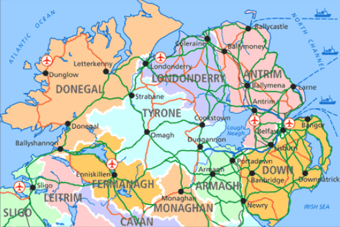
Wegenkaart Noord Ierland - OSI Productomschrijving: Ordnance Survey Ireland North Road map at 1:250,000 approx 4 miles to the Inch This map shows detailed road classification, altitude ...

Specificaties
- Uitgever: Ordnance Survey Ireland
- ISBN-13: 9781905306619
- HOOFDCATEGORIEËN: Wegenkaart - Landkaart
- Activiteiten: Street/Road maps & city plans
- Regio: Noord Ierland
- Land: Ierland
- TOPO's & Stafkaarten: Topografisch wandelen
- Schaal: 1:250000
- Taal: Engels
- Reeks/Serie: Discovery Series, OSI
Volledige omschrijving
Wegenkaart Noord Ierland - OSI
Productomschrijving: Ordnance Survey Ireland North Road map at 1:250,000 approx 4 miles to the Inch
This map shows detailed road classification, altitude colouring and tourist information, published by OSI, the Ordnance Survey of Ireland.
Topography of the island is shown by altitude colouring, with additional spot heights and names of mountain or hill ranges and other geographical features. Additional graphics show different types of woodlands etc. Road network shows six grades of roads; Railway lines are shown with stations.
A range of symbols highlights camping and caravan sites, nature reserves, National Trust and An Taisce properties or land, golf courses (indicating the number of holes), historical sites, etc.
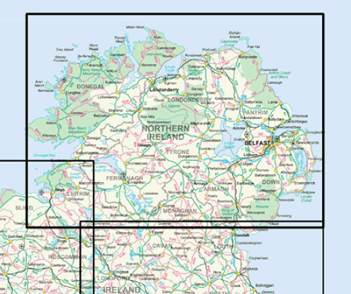 The maps have 10-km Irish national grid, plus latitude and longitude margin ticks at 10 intervals.
No index is provided.
Artikelen uit dezelfde regio

Wandelgids Groot-Brittanië - Lannoo • 9789020906035
Wandelgids Groot-Brittanië - Lannoo Productomschrijving: Lonely Planet laat je actief genieten van het mooiste van Groot-Brittannië. Ontdek Groot-Brittannië op een actieve manier met deze kant-en-klaar uitgestippelde routes van Lonely Planet. Je kiest uit panoramatochten, kustroutes, bergritten, gastronomische circuits en wildlife tours. Tips voor de beste reistijd en de ultieme paklijst z…

Plano Adm. Wandkaart Groot-Brittannië 84 x 119 - Lovell Johns • 9781904892687
Wandkaart Groot-Brittannië 84 x 119 - Lovell Johns Productomschrijving: Toont provincies en unitaire autoriteiten in verschillende kleuren. Arrondissementen en districten worden ook op deze kaart getoond, evenals dorpen en steden. Bevat een kleine postcodekaart van Groot-Brittannië met postcodes, evenals bevolkingsgegevens. Deze administratieve kaart van Verenigd Koninkrijk is ideaal v…

Reigids Great Britain Experience Guide - Lonely Planet • 9781837583461
Lonely Planet Great Britain Experience Guide Productomschrijving: Unique experiences to string together an unforgettable trip Inside Lonely Planet's Experience Great Britain: - Inspiring full-colour travel photography and maps throughout - Highlights and trip builders to help tailor a trip to your personal needs and interests - Fresh perspectives to surprise you with things…

Reisgids Great Britain - Rough Guides • 9781835290415
Great Britain reisgids - Rough Guides Productomschrijving: Full-colour throughout, The Rough Guide to Britain is the ultimate guide to Rough Guides’ home patch. With 30 years experience and our trademark ‘tell it like it is’ writing style, Rough Guides cover all the basics with practical, on-the-ground details, as well as unmissable alternatives to the usual must-see sights. At the top of …

Plano Postcode Wandkaart Groot-Brittannië 84 x 119 - Lovell Johns • 9781910378977
Wandkaart Groot-Brittannië 84 x 119 - Lovell Johns Productomschrijving: De Postcodegebieden van de Britse eilanden worden duidelijk weergegeven en het gebied Groot-Londen wordt uitgebreid om deze postcodegebieden duidelijk te tonen. Bevat informatie, inclusief stads-, provincie- en districtsnamen. Steden zijn gemarkeerd om de geschatte populatie te tonen. Gebruik van de kaart: de postc…