

Landkaart Wegenkaart Fietskaart 448 Kreta West - Terrein Maps
De Westelijke kant van Kreta

Korte omschrijving
Wegenkaart Fietskaart Kreta West - Terrein Maps Productomschrijving: Terrain’s map of Western Crete provides travelers with everything they need: Scale of 100.000, which attributes all ...

Specificaties
- Uitgever: Terrain Editions
- ISBN-13: 9789609456647
- HOOFDCATEGORIEËN: Wegenkaart - Landkaart
- Activiteiten: Street/Road maps & city plans
- Regio: Kreta Griekenland
- Land: Griekenland
- Schaal: 1:100000
- Taal: Engels
- De Griekse Eilanden: Kreta
Volledige omschrijving
Wegenkaart Fietskaart Kreta West - Terrein Maps
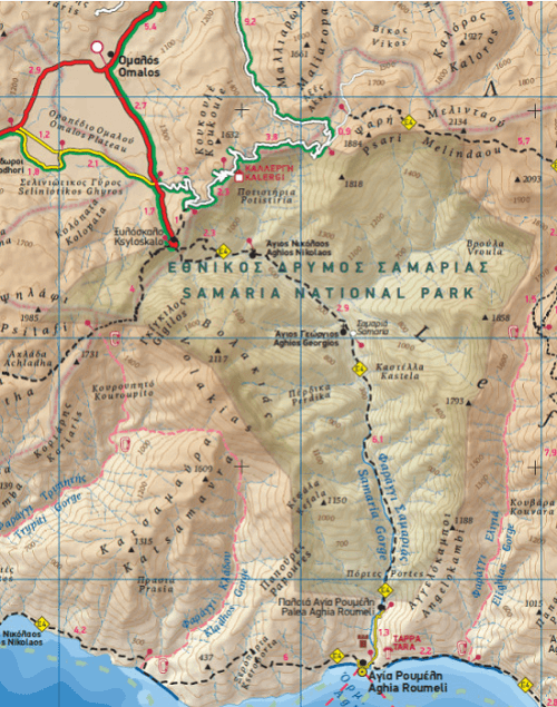
Productomschrijving: Terrain’s map of Western Crete provides travelers with everything they need:
Scale of 100.000, which attributes all the information with clarity and in detail. Map data processed within a GIS environment, resulting in great accuracy. Double coordinate system, WGS 84 and ?GS? 87, completely compatible with GPS.
It is printed on Polyart material, making it totally waterproof and rip-proof. You can fold it and unfold it a hundred times, fold it in irregular ways, dunk it in the sea or leave it out in the rain. This map is indestructible! Clear symbols, easily readable fonts, rich colors and excellent arrangement of every element make the map extremely friendly to the user.
Unique wealth of information. Every village, every road (including their distance in km), every sight, every beach, every gas station, the camping areas and much more, are all included in the map. The most important trails of the area are marked in the map, with clear lines, in two categories (main and secondary trails), including their exact distance in km, as well as the mountain refuges.
For the first time in a map of Crete, the bolted canyoning routes and the climbing crags of the area are included. Moreover, suggested scenic routes are marked with a green shadow on the map. Also, a full index of the place names and the archaeological sites is included, as well as a detailed townplan of Chania in the scale of 1:4.500.
Artikelen uit dezelfde regio
Landkaart Wegenkaart Kreta (Franstalig) - Expressmap • 9788383554266
Wegenkaart Kreta (Franstalig) - Expressmap Productomschrijving: ExpressMap is de uitgever van comfort! maps, geplastificeerde kaarten die eenvoudig te vouwen zijn, zelfs met één hand. Een uniek en innovatief product. Comfortabel, waterbestand, onverscheurbaar, comfort! maps blijven hun kwaliteit lang behouden. Duurzame kaarten, nuttig om een uitstap te plannen en handig voor onderweg. …
Wandelgids Eastern Crete - Kreta Oost - Sunflower Books • 9781856915472
Wandelgids Eastern Crete - Kreta Oost - Sunflower Productomschrijving: Een gids over wandelen op het Griekse eiland Kreta, met 55 van de beste lange en korte dagwandelingen. We bestrijken het oosten van het eiland: het gebied rond Agios Nikolaos - oostwaarts naar Zakros en zuidwaarts naar de kust, met wandelroutes van verschillende moeilijkheidsgraad, die allemaal gedetailleerd in kaart zi…

Landkaart Wegenkaart 154 Lasithi Kreta - Orama Editions • 9789604480098
Wegenkaart Lasithi Kreta - Orama Editions Productomshrijving: Gedetaillieerde wegenkaart van één van de vier departementen van de regio en het eiland Kreta in de Griekse eilanden. De kaart omvat hotels en campings, met toeristische symbolen die allerhande historische plaatsen, kloosters, musea aangeven. De kaart is meertalig, met belangrijke steden met hun centrum kaart en register, en deg…
Wandelkaart 403 Psiloritis & Heraklion Kreta Griekenland- Road Ed • 9789604489510
Wandelkaart Psiloritis & Heraklion Kreta Griekenland - Road Ed Productomschrijving: De wandelroutes rond en op Psiloritis liggen in het centrale deel van Kreta, grotendeels ten zuidwesten van Heraklion-stad. Psiloritis, ook bekend als Mount Ida, is het hoogste gebergte van Kreta met de top Timios Stavros op 2.456 meter. Het massief spreidt zich uit over de regionale eenheden Heraklion en …
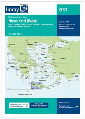
Passage kaart G37 Nísos Kríti (West) - Imray (F&B) • 9781846239359
Passagekaart Nísos Kríti (West) - Imray (F&B) Productomschrijving: Voor deze editie zijn magnetische variatiecurves toegevoegd. De kaart is volledig geactualiseerd.. (Freytag & Berndt) - 1:193.000 Kaart omvat: Het westelijke deel van het eiland Nisos Kriti (Kreta), van Iraklion tot het westelijke puntje. Schaal: 1 : 193.000. Grotere schaalplannen van Ormos Gramvousa, Hania, Rethimno,…