

Landkaart Wegenkaart Explorer Map Mid North Coast, NSW - Hema
Barrington Tops NP- Northern Newcastle- Mudgee- Gunnedah
Korte omschrijving
Explorer Map Mid North Coast, New South Wales - Hema Productomschrijving: A regional map of the Mid North Coast of New South Wales (1:350,000) that ranges from Northern Newcastle, west to M...

Specificaties
- Uitgever: Hema Maps
- ISBN-13: 9781922668226
- HOOFDCATEGORIEËN: Wegenkaart - Landkaart
- Activiteiten: Street/Road maps & city plans
- Regio: New South Wales, Australië
- Land: Australië
- Nationale parken: Barrington Tops Np, New South Wales Australia
- Schaal: 1:350000
- Editie: 1
- Taal: Engels
- Reeks/Serie: Explorer Map reeks, Hema maps
- De Australische Regio's: New South Wales
Volledige omschrijving
Explorer Map Mid North Coast, New South Wales - Hema
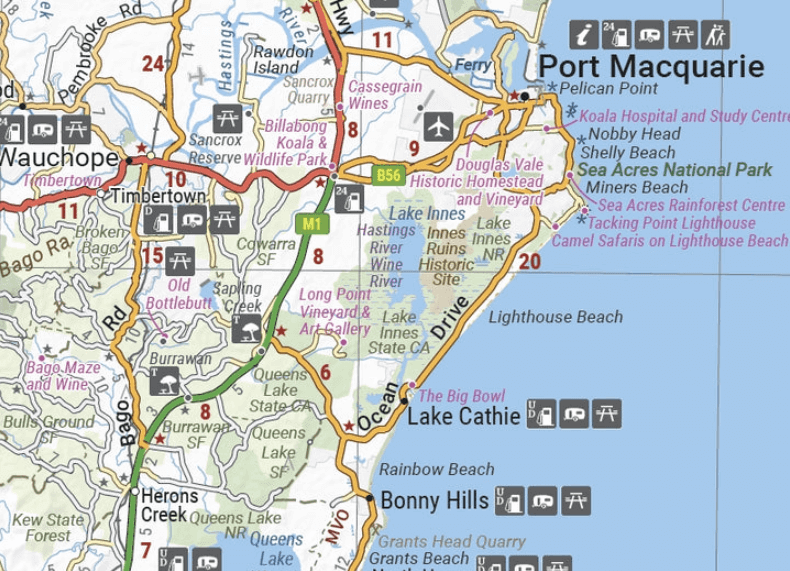
Productomschrijving: A regional map of the Mid North Coast of New South Wales (1:350,000) that ranges from Northern Newcastle, west to Mudgee, as far as Gunnedah in the North and East to Port Macquarie.
Covers: Gunnedah, Tamworth, Mudgee, Port Macquarie, Maitland, Kempsey, Taree, and Forster. Also includes the following National Parks; Barrington Tops NP, Oxley Wild Rivers NP, Hat Head NP, Carrai NP, Werrikimbe NP, Cottan-Bimbang NP, Mummel Gulf NP, Nowendoc NP, Curracabundi NP, Wollemi NP, Goulburn River NP, Yengo NP, and Towarri NP.
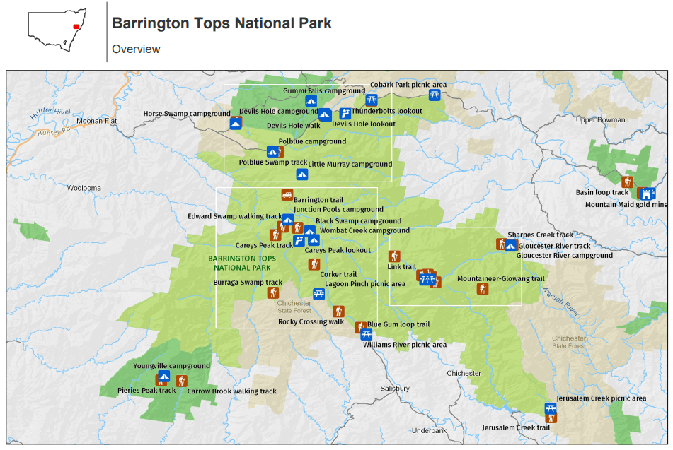
On the opposite side is a detailed inset map of the Barrington Tops National Park (at 1:100,000 scale) plus extensive information on numerous regions, including visitor, historical and background information.
KEY FEATURES
- Comprehensive regional map of the Mid North Coast of New South Wales
- Camping & rest areas
- Fuel locations
- Points of Interest
- Detailed map of Barrington Tops National Park (at 1:100,000 scale)
- Detailed National Park Listing with facilities
- Tourist Information Centres
Artikelen uit dezelfde regio

Landkaart Wegenkaart 244 Sydney to Brisbane - UBD Gregory's • 9780731933280
Wegenkaart Sydney to Brisbane - UBD Gregory's Productomschrijving: The latest edition of the Sydney to Brisbane touring map has been fully revised and updated and includes: - Information on travelling from Sydney to Brisbane via both the Pacific Motorway/Highway and the New England Highway. - Information on choosing to travel between Sydney and Brisbane via either the Pacific or N…
Stadskaart plattegrond Sydney Australia - Borch • 9783866093133
Wandelkaart Sydney Australia - Borch Productomschrijving: Our soft-laminated folded map of Sydney in the 8th edition shows: Inner Sydney 1:15 000, Sydney CBD 1:7 500, Sydney 1:120 000, Sydney & Region 1:450 000, Homebush Bay Olympic Park 1:15 000, Airport Sydney 1:25 000, Public Transport Sydney, Australia administrative & time zones, Top 30 Sights. Borch Maps show hotels, museums, monumen…

Landkaart Wegenkaart 280 Newcastle Suburban Streets - UBD • 9780731931927
Wegenkaart Newcastle Suburban Streets - Gregory's Productomschrijving: The latest edition of the popular Newcastle Hunter Valley & surrounding region Map 280 features coverage at a scale of 1: 450 000 from Ardglen & North Haven in the north & Bateau Bay in the south and along the coast & Merriwa in the west plus an index to the towns noted on this map on one side. On the other side th…

Landkaart Wegenkaart 299 Wollongong Suburban Streets NSW - UBD • 9780731932054
Wegenkaart Wollongong Suburban Streets NSW - UBD Productomschrijving: Street level mapping and street index at a scale of 1 : 25 000 from Helensburgh in the north to Dunmore in the south. Coverage included for Berry & Nowra, North Nowra & Bomaderry - Index to suburbs & localities - Overview map of Wollongong to Nowra at a scale of 1 : 685 700

Stadsplattegrond 259 Canberra Suburban Streets - UBD Gregory's • 9780731933426
Stadskaart Canberra Suburban Streets - UBD Gregory's Productomschrijving: The latest edition of the Canberra Suburban Streets Map has been fully revised and updated and includes street level mapping, suburbs and a street index of Canberra, with coverage north to Casey and south to Banks. Queanbeyan is also covered on this map. There is also detailed coverage of Capital Hill and Canberr…