

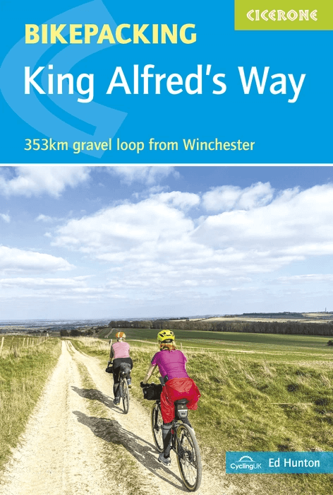
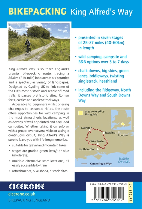
Fietsgids Bikepackin The King Alfred's Way - Cicerone
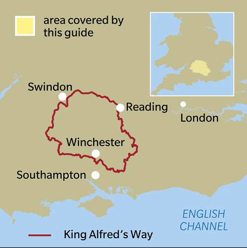
A circular route through southern England - 353 Km
Korte omschrijving
Fietsgidsen South & South East England van CICERONE Press. Ideaal voor tochten in United Kingdom, Great Britain.
Fietsgids Bikepackin King Alfred's Way - Cicerone Productomschrijving: A practical and inspiring guidebook to bikepacking King Alfred’s Way, a 353km circular route through southern England t...

Specificaties
- Uitgever: CICERONE Press
- ISBN-13: 9781786312389
- HOOFDCATEGORIEËN: Fietsgids
- Auteur: Ed Hunton
- Regio: South & South East England
- Land: United Kingdom, Great Britain
- AONB - Area of Outstanding Beauty/National Landscape: North Wessex Downs AONB, Solway coast AONB, Surrey Hills AONB, Wessex Downs AONB
- Schaal: 1:25000
- Editie: 1
- Taal: Engels
- Fietsen: Fietsen in het Buitenland
- National Trails UK, England & Wales: The RidgeWay, England
Volledige omschrijving
Fietsgids Bikepackin King Alfred's Way - Cicerone
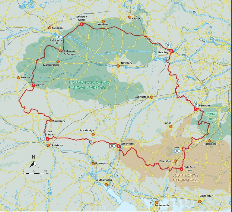
Productomschrijving: A practical and inspiring guidebook to bikepacking King Alfred’s Way, a 353km circular route through southern England that weaves together ancient trackways, rolling chalk downs and quiet rural lanes. Riding through landscapes shaped by thousands of years of history, the route links some of the most iconic off-road trails in the country, including the Ridgeway, North Downs Way and South Downs Way, with long stretches of traffic-free riding and big open views.
Designed by Cycling UK and presented here in a clear, rider-focused format, this guidebook helps you plan and ride the loop with confidence. Divided into seven manageable stages of between 40 and 60km, it suits both beginner and experienced MTB and gravel riders, whether you are looking for a relaxed multi-day adventure or a more ambitious challenge. Clear mapping, detailed stage descriptions and flexible itinerary options make it easy to tailor the ride to your time, fitness and preferred style of overnight stop, from wild camping to campsites and comfortable accommodation.
- Seven stages graded for difficulty, from easy to moderate
- GPX files available to download for easy navigation
- 1:150,000 maps included for each stage
- Alternative schedules breaking the route into between 3 and 7 days
- Route summary tables, accommodation listings and suggested wild camping spots to help plan your itinerary
- Easily accessible by train from London and from the north and west of the UK.
The route:
Stage 1 Test Valley: Winchester to Old Sarum
Stage 2 Salisbury Plain: Old Sarum to Chirton
Stage 3 Vale of Pewsey and Ridgeway Part I: Chirton to Uffington Castle
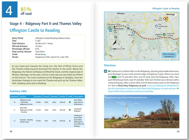
Stage 4 Ridgeway Part II and Thames Valley: Uffington Castle to Reading
Stage 5 Forest of Eversley: Reading to Farnham
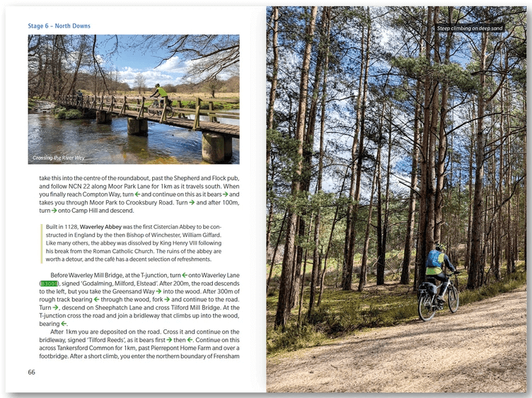
Stage 6 North Downs: Farnham to Forty Acre Lane
Stage 7 South Downs: Forty Acre Lane to Winchester
Appendix A Accommodation
Appendix B Bike shops
Appendix C Recommended kit lists
Artikelen uit dezelfde regio
Reisgids Country guide Sud de l'Angleterre - Petit Futé • 9782305122274
Reisgids Sud de l'Angleterre - Petit Futé Productomschrijving: La série télévisée britannique à succès Broadchurch a jeté un coup de projecteur sur cette destination si proche de la France et qui n'a rien a envier à nos cotes normandes. Partir pour le Sud de l'Angleterre, c'est découvrir Londres, bien sur, mais aussi la Manche, située à quelques kilomètres de la capitale, et le Sussex…

Wandelgids - North Downs Way - Map Booklet - Cicerone • 9781852849559
Wandelgids - North Downs Way - Map Booklet - Cicerone Productomschrijving: Kaart van de 208km, over de North Downs Way National Trail, tussen Farnham en Dover, met inbegrip van een optioneel bezoek aan Canterbury. Dit boekje is opgenomen in de Cicerone gids en toont het volledige parcours op OS 1: 25.000 kaarten. Een van de eenvoudigere nationale routes, dat comfortabel kan worden gelopen …

Wandelgids - North Downs Way Nat. trail - Cicerone • 9781852848613
Wandelgids North Downs Way Nat. trail - Cicerone Productomschrijving: Een wandelgids over de North Downs Way nationale Trail, een parcours van de 130 mijl (208km) tussen Farnham en Dover, met een optioneel bezoek aan de Canterbury. Naar aanleiding van de grotendeelse oude pelgrimsroute, door aangenaam platteland, dit is een van de éénvoudigere nationale routes waar de wandeling over 11 eta…

Wandelgids The Pilgrim's Way - Cicerone • 9781852847777
Wandelgids - The Pilgrim's Way - Cicerone Productomschrijving: Een samenstelling van alle route gegevens van deze uitermate gekende St-jacobs/bedevaart wandelroute in hartje Engeland. Product description: This guidebook details the Pilgrims' Way, an historic pilgrimage route to Canterbury Cathedral in Kent, home of the shrine of the martyred archbishop, St Thomas Becket. The route is…

Wandelkaart Ridgeway National Trail SE England - Harvey maps • 9781851374786
Wandelkaart Ridgeway National Trail SE England - Harvey maps Productomschrijving: Toont de gehele route van de Ridgeway op één plan, vanaf Overton Hill in de buurt van Avebury in Wiltshire naar Ivinghoe Beacon, ten oosten van Tring in Hertfordshire 137 km (85 mijl). Geschikt voor wandelaars, fietsers en ruiters. Informatie over het vinden van accommodatie, camping, voedsel. Routebeschrijvi…