

Wandelkaart Suilven - Northern Highlands XT40 ultra - Harvey maps
Met Stac Pollaidh & Lochinver

Korte omschrijving
Wandelkaarten Northern Highland's, Schotland van HARVEY MAPS. Ideaal voor tochten in Schotland.
Wandelkaart Suilven - Northern Highlands - Harvey maps Productomschrijving: De kaart omvat een groot gebied, en is een praktisch en compact zakformaat. Dit is een fantastisch en mooi gebied,...

Specificaties
- Uitgever: HARVEY MAPS
- ISBN-13: 9781851376483
- HOOFDCATEGORIEËN: Wandelkaart
- Activiteiten: Wandelen, Hiking & Trekking
- Regio: Northern Highland's, Schotland
- Land: Schotland
- Schaal: 1:40000
- Taal: Engels
- Reeks/Serie: National Trails, UK, Superwalker XT40, Harvey Maps
- Iconische Bergketens van Europa: De Schotse Highlands
Volledige omschrijving
Wandelkaart Suilven - Northern Highlands - Harvey maps
Productomschrijving: De kaart omvat een groot gebied, en is een praktisch en compact zakformaat. Dit is een fantastisch en mooi gebied, met Suilven centraal. De kaart bevat de twee Munros van Ben More Assynt en Conival, alsook andere bekende bergen zoals Cul Mor, Cul Beag, Canisp en Stac Pollaidh. De kaart bedekt het gebied naar het noorden, met een inzet van Quinag.
- Gedetailleerde kaart voor lopers en wandelaars van Suilven en omgeving.- Interessante plaatsen.
- Omvat 2 Munros, 8 Corbetts en 3 Grahams. - Heeft de voordelen van zijn grotere broers:
- Gebruik zonder plastic hoesje: stevig en 100% waterbestendig
- Opent direct aan beide zijden van het blad
Locatie op kaart
Artikelen uit dezelfde regio
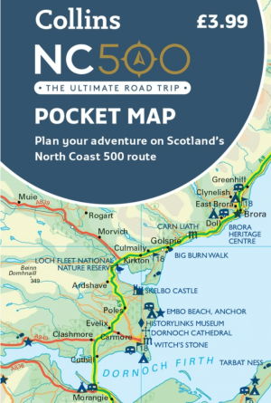
Landkaart Wegenkaart Schotlands North Coast 500 pocket map • 9780008780432
Wegenkaart Schotlands North Coast NC 500 pocket map Productomschrijving: Explore new places with handy pocket maps from Harper Collins. Handy little full colour map of the popular North Coast 500 route. A perfect guide for travelling around Northern Scotland. Detailed mapping and tourist information ideal for any road trip. Main features of this map include: • Clear mapping • T…
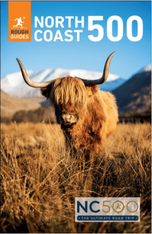
Reisgids The Scotish North Coast 500 - Rough Guides • 9781835294161
The North Coast 500 - Rough Guides Productomschrijving: Discover the North Coast 500 with this compact, entertaining, 'tell it like it is' Rough Guide, packed with invaluable practical guidance and honest expert recommendations across 86 information-packed pages. Whether you plan to take a photo with the John O' Groats sign or visit the fishing town of Ullapool, The Rough Guide to the…

Wandelgids Walking The Munros vol. 2 - Cicerone Press • 9781786311061
Wandelgids Walking The Munros vol. 2 - Cicerone Productomschrijving: Deel 2 van Walking the Munros, deze gids beschrijft 70 uitdagende en inspirerende routes op Schotlands iconische 3000ft+ bergen in de Northern Highlands, de Cairngorms en het Isle of Skye. De routes, die variëren van 7 tot 46 km (met de mogelijkheid om de loopafstand op sommige van de langere routes te verminderen door de…

Landkaart Wegenkaart 2 Schotland West & Western Isles - OSI • 9780319263747
Wegenkaart Schotland West & Western Isles - OSI Productomschrijving: Plan your journey with this series of road maps from OS. Showing all major road, rail and ferry links as well as settlements and selected features in 1: 250 000 scale, this is the ideal map for planning trips and holidays by car or cycle. OS Road 2 covers: Scotland's west coast, including the Western Isles (Hebrides)…
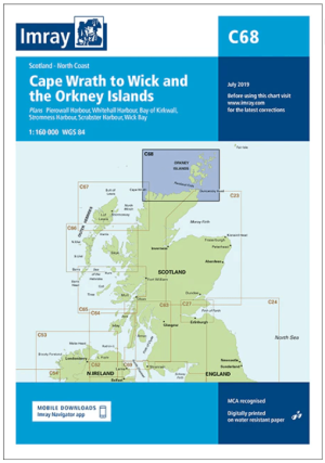
Passage kaart C068 Cape Wrath tot Wick en de Orkney-eilanden • 9781846239298
PassagekaartCape Wrath tot Wick en de Orkney-eilanden - Imray (F&B) Productomschrijving: De noordkust van Schotland van Cape Wrath tot Wick, inclusief de Pentland Firth en de Orkney-eilanden. Grotere schaalplannen van Pierowall, Kirkwall, Whitehall Harbour, Wick Bay, Stromness en Scrabster. Op schaal 1: 160.000 De Imray Charts C-serie bestrijken vaargebieden in Noordwest-Europa, en…