

Wandelkaart Mini - 1244 OT - Biarritz- Hendaye & La Rhune
Biarritz & Hendaye zijn kustgemeenten in Franse hoekje

Korte omschrijving
Wandelkaarten Nouvelle-Aquitaine, Frankrijk van Institut Géographique National. Ideaal voor tochten in Frankrijk.
Wandelkaart MINI - Biarritz- Hendaye & La Rhune - IGN Productomschrijving: Deze essentiële wandelkaart & topografische kaarten van zeer hoge kwaliteit, en bevatten alle details die op de gro...

Specificaties
- Uitgever: Institut Géographique National
- ISBN-13: 9782758551027
- HOOFDCATEGORIEËN: Wandelkaart
- Activiteiten: Wandelen, Hiking & Trekking
- Regio: Nouvelle-Aquitaine, Frankrijk
- Land: Frankrijk
- Departement: Pyrénées-Atlantiques (64)
- TOPO's & Stafkaarten: Topografisch wandelen
- Schaal: 1:25000
- Editie: 1
- Taal: Frans
- Reeks/Serie: IGN France > TOP25 Randoo, IGN France > TOP25 Randoo > TOP25 MINI
Volledige omschrijving
Wandelkaart MINI - Biarritz- Hendaye & La Rhune - IGN
Productomschrijving: Deze essentiële wandelkaart & topografische kaarten van zeer hoge kwaliteit, en bevatten alle details die op de grond aanwezig zijn, van wandelroutes tot aan het smalste paden, zonder de weergave van het reliëf te vergeten. Op de TOP25 staan gemarkeerde wandelroutes en toeristische informatie.
Franse omschrijving: L'indispensable carte de randonnée ! Ces cartes topographiques d'une très grande précision contiennent tous les détails existants sur le terrain : voies de communication jusqu'au moindre sentier, constructions jusqu'au hangar, bois, arbre isolé, rivière, source... Sans oublier la représentation du relief par des courbes de niveau. Sur les TOP25 les sentiers balisés et les informations touristiques sont signalés.
Locatie op kaart
Artikelen uit dezelfde regio

Wandelkaart 1545 ET Pau Aquitaine France - IGN • 9782758535904
TOPO Wandelkaart Pau Aquitaine France - IGN Omvat: Pau is tevens prefectuur van het departement Pyrénées-Atlantiques, in de regio Aquitanië. Productomschrijving: Tussen 2014 en 2018 vernieuwt IGN haar volledige collectie serie blauw. Een nieuwe toewijzing voor optimale leesbaarheid, met een grotere mate van geometrische nauwkeurigheid en verrijkte toeristische informatie. Het formaat v…

Fietsgids Ile de Ré balades à vélo - Sud Ouest Editions • 9782817712284
Fietsgids Ile de Ré balades à vélo - Sud Ouest Productomschrijving: Balades à vélo dans l'île de Ré : Plus de 20 balades en famille Entre landes sauvages, petits bois, marais salants, plages et adorables villages, ces 20 balades, à parcourir à vélo, sont idéales pour partager des moments en famille ou entre amis

Wandelgids PNR du Marais poitevin à pied - Ed. Chamina • 9782844664440
Parc Naturèl Régionales du Marais poitevin à pied Productomschrijving: 22 bijzondere wandelingen, waarvan 4 in de Vendée. De wandelingen in deze gids bieden een complete panorama van het departement Deux-Sèvres: rond Thouars, Bressuire, Parthenay en Melle. Maar ook de Marais Poitevin, tussen Niort en Fontenay-le-Comte (85), komt aan bod. Dit natuurgebied, dat zich uitstrekt van de Deux…
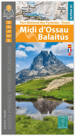
Wandelkaart Midi d'Ossau - Balaitus - PN Pyrénées Ouest - Alpina • 9788470110948
Wandelkaart Midi d'Ossau & Balaitus - IGN Productomschrijving: Het Nationaal park van de Pyreneeën strekt zich uit voor 100 km, 6 valleien, 2 departementen & 2 regio's. Deze kaart bestaat uit 2 kaarten, en omvatten de westelijke zijde van het nationaal park. Omvat de massieven van de Vignemale, Balaitus en de piek van de Midi d'Ossau. Omvat: Het Nationaal Park Pyreneeën. Pyrénées-Atlan…

Wandelgids Vallées d'Ossau, d'Aspe et de Barétous à pied- Chamina • 9782844667038
Vallées d'Ossau, d'Aspe et de Barétous à pied - Chamina Productomschrijving: Les vallées d'Ossau, d'Aspe et de Barétous, sont les 3 vallées béarnaises qui entaillent la chaîne pyrénéenne entre Bigorre et Pays basque. Elles communiquent avec l'Aragon aux cols du Pourtalet et du Somport, et avec la Haute-Navarre au col de la Pierre-Saint-Martin. C'est une région des Pyrénées qui combine de …