

Wandelkaart 852 Hellsgate- Salome- Sierra Ancha Wilderness Areas
Coconino - Apache-Sitgreaves National Forests - Roosevelt Lake

Korte omschrijving
Wandelkaarten Arizona, USA van National Geographic. Ideaal voor tochten in Verenigde Staten van Amerika (USA).
Hellsgate- Salome- Sierra Ancha Wilderness Areas - Nat Geo Productomschrijving: Tonto National Forest is een van de grootste nationale bossen in de Verenigde Staten en staat niet alleen beke...

Specificaties
- Uitgever: National Geographic
- ISBN-13: 9781566954860
- HOOFDCATEGORIEËN: Wandelkaart
- Activiteiten: Wandelen, Hiking & Trekking
- Auteur: National Geographic
- Regio: Arizona, USA
- Land: Verenigde Staten van Amerika (USA)
- Waterafstotende kaart: Nat Geo waterproof series
- Nationale parken: Tonto National Forest, Arizona USA
- TOPO's & Stafkaarten: Topografisch wandelen
- Schaal: 1:70000
- Taal: Engels
- Reeks/Serie: National Geographic Trails Illustrated
Volledige omschrijving
Hellsgate- Salome- Sierra Ancha Wilderness Areas - Nat Geo
Productomschrijving: Tonto National Forest is een van de grootste nationale bossen in de Verenigde Staten en staat niet alleen bekend om zijn diversiteit aan terrein, flora en fauna, maar ook om zijn vele recreatieve mogelijkheden het hele jaar door. Deskundig onderzocht en gemaakt in samenwerking met de U.S. Forest Service, Bureau of Land Management en anderen, National Geographic's Trails Illustrated kaart van Hellsgate, Salome, en Sierra Ancha Wilderness Areas biedt ongeëvenaarde details van de noordoostelijke regio van het bos, samen met nabijgelegen gebieden in Coconino en Apache-Sitgreaves National Forests.
De kaart omvat veel populaire recreatiegebieden, waaronder Roosevelt Lake and Wildlife Area, Woods Canyon en Willow Springs Lakes, Mogollon Rim Area en Sierra Ancha Mountains.
Omvat: Aztec Peak, Coconino National Forest, Four Peaks, Four Peaks Wilderness, Hellsgate Wilderness, Mazatzal Mountains, Payson, Salome Wilderness, Salt River Canyon Wilderness, Sierra Ancha, Sierra Ancha Wilderness, Sitgreaves National Forest, Sombrero Peak, Theodore Roosevelt Lake, Tonto Basin, Tonto National Forest.
Engelse omschrijving: One of the largest national forests in the United States, Tonto National Forest is known not only for its diversity of terrain, flora and fauna but also for its numerous recreational opportunities throughout the year. Expertly researched and created in cooperation with the U.S. Forest Service, Bureau of Land Management and others, National Geographic's Trails Illustrated map of Hellsgate, Salome, and Sierra Ancha Wilderness Areas provides unmatched detail of the northeast region of the forest along with nearby areas in Coconino and Apache-Sitgreaves National Forests. The map's coverage includes many popular recreation areas, including Roosevelt Lake and Wildlife Area, Woods Canyon and Willow Springs Lakes, Mogollon Rim Area and Sierra Ancha Mountains.
Whether you explore the region on foot, skis, bike, horseback or motorized vehicle, you can get off the beaten path and back on again by following the map to clearly marked trails, which are labeled according to their designated usage, as well as the numbered Forest Service roads. The Highline, General Crook and Arizona Trails are all highlighted. Your navigation of the area will be aided by the map's contour lines, elevations, labeled peaks and summits, water features, selected waypoints and clear boundaries between public, private and tribal lands. Recreation points of interest include campgrounds and primitive camp sites, trailheads, fishing areas, boat launch and river access points, interpretive trails and scenic viewpoints.
Every Trails Illustrated map is printed on "Backcountry Tough" waterproof, tear-resistant paper. A full UTM grid is printed on the map to aid with GPS navigation.
Overzichtskaarten
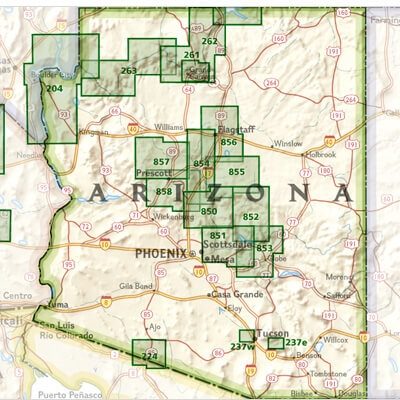
NAT GEO Arizona trail maps
NAT GEO Arizona trail maps

Producten op de overzichtskaart
Klik op een product om naar de detailpagina te gaan.
Artikelen uit dezelfde regio
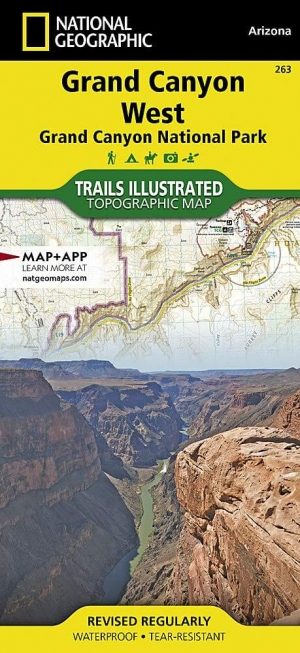
Wandelkaart 263 Grand Canyon West NP- Arizona - Nat Geo • 9781566954969
TOPO Wandelkaart 263 - Grand Canyon West NP - Arizona Productomschrijving: De Grand Canyon is een zeer brede en diepe kloof in het noorden van de Amerikaanse staat Arizona. In de loop van miljoenen jaren heeft het water van de Colorado deze kloof in het landschap doen ontstaan. Deze extreme erosie werd mogelijk doordat het gebied waarin de kloof ligt steeds verder omhoog rees. Engelse …
Reisgids Californië- Arizona- Nevada & Utah - Gottmer • 9789025779139
Californië- Arizona- Nevada & Utah van Gottmer Productomschrijving: Of je nu nieuwsgierig bent naar cultuurbepalende wereldsteden als San Francisco en Los Angeles dan wel je juist graag terugtrekt in de natuur: de zuidwestelijke hoek van de VS is voor iedereen een gebied vol hoogtepunten. Californië trekt het grootste aantal bezoekers, gevolgd door de Grand Canyon in Arizona, de nationale …
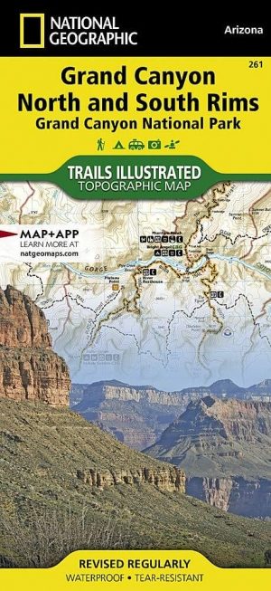
Wandelkaart 261 Grand Canyon NP - Bright Angel - Arizona • 9781566954952
TOPO Wandelkaart 261 - Grand Canyon NP - Bright Angel- Arizona Productomschrijving: De Grand Canyon is een zeer brede en diepe kloof in het noorden van de Amerikaanse staat Arizona. In de loop van miljoenen jaren heeft het water van de Colorado deze kloof in het landschap doen ontstaan. Deze extreme erosie werd mogelijk doordat het gebied waarin de kloof ligt steeds verder omhoog rees. …

Reisgids Grand Canyon national park Utah USA - Lonely Planet • 9781838697877
Grand Canyon national park - Lonely Planet Productomschrijving: Lonely Planet Grand Canyon National Park is uw paspoort voor het meest relevante, up-to-date advies over wat te zien en over te slaan, en welke verborgen ontdekkingen op u wachten. Ga raften op de Colorado River, rijd op een muilezel naar beneden in de Grand Canyon, of bekijk het van bovenaf tijdens een helikoptervlucht rond d…

Stadskaart plattegrond Phoenix Arizona USA - Borch • 9783866093010
Wandelkaart Phoenix Arizona USA - Borch Productomschrijving: Our soft-laminated folded map of Phoenix in the 8th edition shows: Phoenix 1:105.000, Downtown Phoenix 1:20.000, Downtown Scottsdale 1:20.000, Arizona 1:3.050.000, Heritage Square 1: 3.000, Sky Harbour International Airport, USA administrative & time zones, Top 30 sights. Borch maps are easy to fold, durable and water-repellent w…