

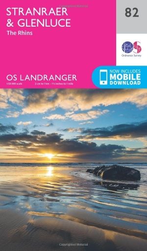
Wandelkaart 82 Stranraer & Glenluce - Schotland - OSI
New Luce- Kirkcowan- Dunragit- Stoneykirk & Ardwell

Korte omschrijving
Wandelkaarten Dumfries & Galloway, Schotland van Ordnance Survey. Ideaal voor tochten in Schotland.
Wandelkaart Stranraer & Glenluce - Dumfries & Galloway Productbeschrijving: De OS Landranger-kaart 82 van Stranraer & Glenluce bevat ook New Luce, Kirkcowan, Dunragit, Stoneykirk, Ardwell, P...

Specificaties
- Uitgever: Ordnance Survey
- ISBN-13: 9780319474051
- HOOFDCATEGORIEËN: Wandelkaart
- Activiteiten: Wandelen, Hiking & Trekking
- Regio: Dumfries & Galloway, Schotland
- Land: Schotland
- Waterafstotende kaart: Ordnance Survey ACTIVE Landranger Weatherproof Maps
- TOPO's & Stafkaarten: Topografisch wandelen
- Schaal: 1:50000
- Taal: Engels
- Reeks/Serie: Landranger ACTIVE series OSI
Volledige omschrijving
Wandelkaart Stranraer & Glenluce - Dumfries & Galloway
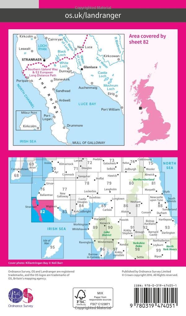
Productbeschrijving: De OS Landranger-kaart 82 van Stranraer & Glenluce bevat ook New Luce, Kirkcowan, Dunragit, Stoneykirk, Ardwell, Port Lagan, Drummore, Port Patrick, alsook een onderdeel van de E2 Europese Long Distance pad en deel van de Southern Upland Way. Stranraer is de haven van de veerboot naar Belfast in Noord-Ierland, u kunt er ook het kasteel van St John of kasteel Kennedy bezoeken.
De OS Landranger kaarten reeks heeft betrekking op Groot-Brittannië met 204 gedetailleerde kaarten, perfect voor dagtochten en korte pauzes. Elke kaart bevat alle informatie die u nodig heeft om dit lokaal gebied te leren kennen en omvat plaatsen van belang, toeristische informatie, picknickplaatsen en campings, plus doorgangsrechten informatie voor Engeland en Wales.
Productdiscription: The OS Landranger map 82 of Stranraer & Glenluce also includes New Luce, Kirkcowan, Dunragit, Stoneykirk, Ardwell, Port Lagan, Drummore, Port Patrick, part of the E2 European Long Distance Path and part of the Southern Upland Way. Stranraer is the ferry port to Belfast in Northern Ireland, but you can also visit the Castle of St John or Castle Kennedy.
The OS Landranger Map series covers Great Britain with 204 detailed maps, perfect for day trips and short breaks. Each map provides all the information you need to get to know your local area and includes places of interest, tourist information, picnic areas and camp sites, plus Rights of Way information for England and Wales. The OS Landranger map for Stranraer & Glenluce is available in both the standard paper version and weatherproof "Active" version.
Locatie op kaart
Gekoppelde artikelen
Wandelkaart 82 Stranraer & Glenluce - Schotland - OSI • 9780319261804
standaard versieWandelkaart Stranraer & Glenluce - Schotland Productbeschrijving: OS Landranger kaart 82 van Stranraer & Glenluce bevat ook nieuwe Luce, Kirkcowan, Dunragit, Stoneykirk, Ardwell, Port Lagan, Drummore, Port Patrick, onderdeel van de E2 Europese Long Distance pad en deel van de Southern Upland Way. Stranraer is de haven van de veerboot naar Belfast in Noord-Ierland, maar u kunt er ook het ka…

Wandelkaart 82 Stranraer & Glenluce - Schotland - OSI • 9780319474051
weatherproof versieWandelkaart Stranraer & Glenluce - Dumfries & Galloway Productbeschrijving: De OS Landranger-kaart 82 van Stranraer & Glenluce bevat ook New Luce, Kirkcowan, Dunragit, Stoneykirk, Ardwell, Port Lagan, Drummore, Port Patrick, alsook een onderdeel van de E2 Europese Long Distance pad en deel van de Southern Upland Way. Stranraer is de haven van de veerboot naar Belfast in Noord-Ierland, u ku…
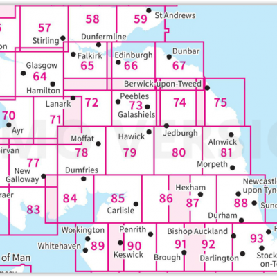
Overzichtskaarten
OSI Landranger & Landranger Active - Noord Engeland - Lake District
OSI Landranger & Landranger Active - Noord Engeland - Lake District
Producten op de overzichtskaart
Klik op een product om naar de detailpagina te gaan.
- Wandelkaart 70 Ayr- Kilmarnock & Troon- Schotland - OSI
- Wandelkaart 70 Ayr- Kilmarnock & Troon- Schotland - OSI
- Wandelkaart 71 Lanark & Upper Nithsdale- Schotland - OSI
- Wandelkaart 71 Lanark & Upper Nithsdale- S. Lanarkshire - OSI
- Wandelkaart 72 Upper Clyde Valley- Lanarkshire - OSI
- Wandelkaart 72 Upper Clyde Valley- Lanarkshire - OSI
- Wandelkaart 73 Peebles- Galashiels & Selkirk - Schotland - OSI
- Wandelkaart 73 Peebles- Galashiels & Selkirk - Schotland - OSI
- Wandelkaart 74 Kelso & Coldstream - Schotland - OSI
- Wandelkaart 74 Kelso & Coldstream - Schotland - OSI
- Wandelkaart 75 Berwick-upon-Tweed- England - OSI
- Wandelkaart 75 Berwick-upon-Tweed- Northumberland - OSI
- Wandelkaart 76 Girvan- South Ayrshire- Schotland - OSI
- Wandelkaart 76 Girvan- South Ayrshire-Schotland - OSI
- Wandelkaart 77 Dalmellington & New Galloway- Schotland - OSI
- Wandelkaart 77 Dalmellington & New Galloway- Schotland - OSI
- Wandelkaart 78 Nithsdale & Annandale- Schotland - OSI
- Wandelkaart 78 Nithsdale & Annandale- Schotland - OSI
- Wandelkaart 79 Hawick & Eskdale - Schotland - OSI
- Wandelkaart 79 Hawick & Eskdale- Schotland - OSI
- Wandelkaart 80 Cheviot Hills & Kielder Water- England - OSI
- Wandelkaart 80 Cheviot Hills & Kielder Water- England - OSI
- Wandelkaart 81 Alnwick & Morpeth - Northumberland - OSI
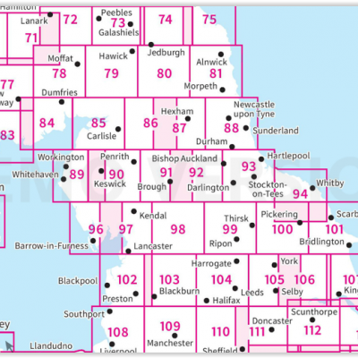
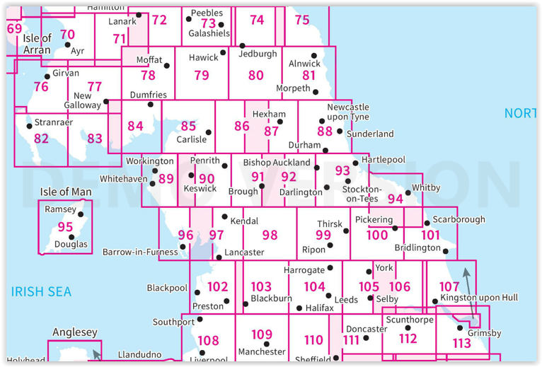
- Wandelkaart 82 Stranraer & Glenluce - Schotland - OSI
- Wandelkaart 82 Stranraer & Glenluce - Schotland - OSI
- Wandelkaart 83 Newton Stewart & Kirkcudbright- Schotland - OSI
- Wandelkaart 83 Newton Stewart & Kirkcudbright- Schotland - OSI
- Wandelkaart 84 Dumfries & Castle Douglas- Schotland - OSI
- Wandelkaart 84 Dumfries & Castle Douglas- Schotland - OSI
- Wandelkaart 85 Carlisle & Solway Firth- Cumbria England - OSI
- Wandelkaart 85 Carlisle & Solway Firth- Cumbria England - OSI
- Wandelkaart 86 Haltwhistle & Brampton - OSI
- Wandelkaart 86 Haltwhistle & Brampton - OSI
- Wandelkaart 87 Hexham & Haltwhistle- England - OSI
- Wandelkaart 87 Hexham & Haltwhistle- England - OSI
- Wandelkaart 88 Newcastle upon Tyne- N.E. England - OSI
- Wandelkaart 88 Newcastle upon Tyne- N.E. England - OSI
- Wandelkaart 89 West Cumbria England - OSI
- Wandelkaart 89 West Cumbria England - OSI
- Wandelkaart 90 Penrith & Keswick - Lake District NP - OSI
- Wandelkaart 90 Lake Distrist NP - Penrith & Keswick - OSI
- Wandelkaart 91 Appleby-in-Westmorland - OSI
- Wandelkaart 91 Appleby-in-Westmorland - OSI
- Wandelkaart 92 Barnard Castle Teesdale - England - OSI
- Wandelkaart 92 Barnard Castle Teesdale - England - OSI
- Wandelkaart 93 Middlesbrough & Darlington- England - OSI
- Wandelkaart 93 Middlesbrough & Darlington- England - OSI
- Wandelkaart 94 Whitby & Esk Dale- North Yorkshire - OSI
- Wandelkaart 94 Whitby & Esk Dale- North Yorkshire - OSI
- Wandelkaart 95 Isle of Man- England - OSI
- Wandelkaart 95 Isle of Man- England - OSI
- Wandelkaart 96 Barrow-in-Furness & South Lakeland - OSI
- Wandelkaart 96 Barrow-in-Furness & South Lakeland - OSI
- Wandelkaart 97 Kendal & Morecambe- Cumbria - OSI
- Wandelkaart 97 Kendal & Morecambe- Cumbria - OSI
- Wandelkaart 99 Northallerton & Ripon- N. Yorkshire - OSI
- Wandelkaart 99 Northallerton & Ripon- N. Yorkshire - OSI
- Wandelkaart 100 Malton & Pickering- Yorkshire - OSI
- Wandelkaart 100 Malton & Pickering- Yorkshire - OSI
- Wandelkaart 101 Scarborough- Bridlington & Filey - OSI
- Wandelkaart 101 Scarborough- North Yorkshire - OSI
- Wandelkaart 102 Preston & Blackpool- Lancashire - OSI
- Wandelkaart 102 Preston & Blackpool- Lytham - OSI
- Wandelkaart 103 Blackburn & Burnley- N.W. England - OSI
- Wandelkaart 103 Blackburn- Burnley & Clitheroe - OSI
- Wandelkaart 104 Leeds & Bradford - West Yorkshire - OSI
- Wandelkaart 104 Leeds & Bradford & Harrogate - OSI
- Wandelkaart 105 York & Selby- North Yorkshire - OSI
- Wandelkaart 105 York & Selby- North Yorkshire - OSI
- Wandelkaart 106 Market Weighton- East Riding of Yorkshire - OSI
- Wandelkaart 106 Market Weighton- Goole- England - OSI
- Wandelkaart 107 Kingston upon Hull- Beverley - OSI
- Wandelkaart 107 Kingston upon Hull- Yorkshire - OSI
- Wandelkaart 108 Liverpool & Southport - England - OSI
- Wandelkaart 108 Liverpool- Merseyside England - OSI
- Wandelkaart 109 Greater Manchester England - OSI
- Wandelkaart 109 Manchester- Bolton & Warrington - OSI
- Wandelkaart 110 Sheffield & Huddersfield - Glossop - OSI
- Wandelkaart 110 Sheffield & Huddersfield - Yorkshire - OSI
- Wandelkaart 111 Sheffield & Doncaster England - OSI
- Wandelkaart 111 Sheffield & Doncaster- Rotherham - OSI
- Wandelkaart 112 Scunthorpe & Gainsborough - OSI
- Wandelkaart 112 Scunthorpe & Gainsborough - OSI
- Wandelkaart 113 Grimsby- Louth & Market Rasen - OSI
- Wandelkaart 113 Grimsby- North East Lincolnshire - OSI
OSI Landranger & Landranger Active - Zuid Schotland & Scotisch Borders
OSI Landranger & Landranger Active - Zuid Schotland & Scotisch Borders
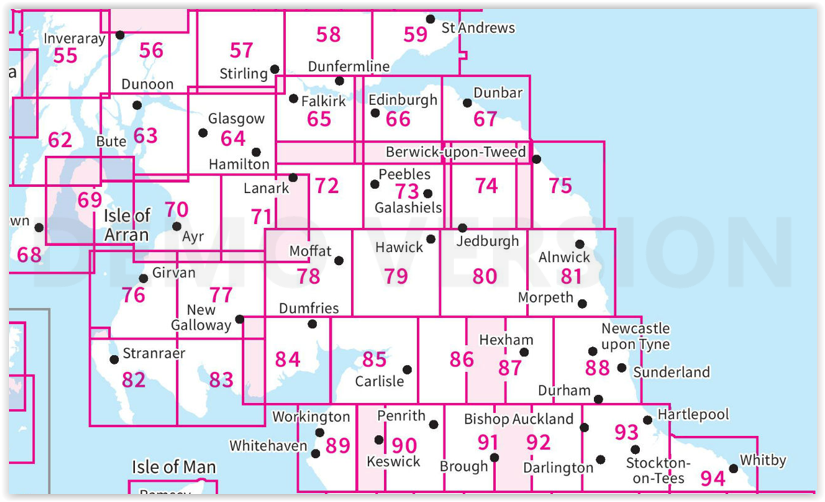
Producten op de overzichtskaart
Klik op een product om naar de detailpagina te gaan.
- Wandelkaart 55 Lochgilphead & Loch Awe - OSI
- Wandelkaart 55 Lochgilphead & Loch Awe - OSI
- Wandelkaart 56 Loch Lomond & Inveraray- Trossachs NP - OSI
- Wandelkaart 56 Loch Lomond & Inveraray- Trossachs NP - OSI
- Wandelkaart 57 Stirling & The Trossachs NP - Highland's - OSI
- Wandelkaart 57 Stirling & The Trossachs NP - Schotland - OSI
- Wandelkaart 58 Perth & Alloa - Perth & Kinross - OSI
- Wandelkaart 58 Perth & Alloa - perth & Kinross - OSI
- Wandelkaart 59 St-Andrews- Fife Schotland - OSI
- Wandelkaart 59 St-Andrews- Fife- Schotland - OSI
- Wandelkaart 62 North Kintyre & Tarbert - Schotland - OSI
- Wandelkaart 62 North Kintyre & Tarbert - Schotland - OSI
- Wandelkaart 63 Firth of Clyde- Argyl & Bute - Schotland - OSI
- Wandelkaart 63 Firth of Clyde- Argyl & Bute - Schotland - OSI
- Wandelkaart 64 Glasgow City Schotland - OSI
- Wandelkaart 64 Glasgow City Schotland- OSI
- Wandelkaart 65 Falkirk & Linlithgow - Edinburgh - OSI
- Wandelkaart 65 Falkirk & Linlithgow - West Schotland - OSI
- Wandelkaart 66 Edinburgh - Western Schotland - OSI
- Wandelkaart 66 Edinburgh - Western Schotland - OSI
- Wandelkaart 67 Duns- Dunbar & Eyemouth- Schotland - OSI
- Wandelkaart 67 Duns- Dunbar & Eyemouth- Schotland - OSI
- Wandelkaart 68 South Kintyre & Campbeltown - OSI
- Wandelkaart 68 South Kintyre & Campbeltown - OSI
- Wandelkaart 69 Isle of Arran - Inner Hybrids - OSI
- Wandelkaart 69 Isle of Arran - Inner Hybrids - OSI
- Wandelkaart 70 Ayr- Kilmarnock & Troon- Schotland - OSI
- Wandelkaart 70 Ayr- Kilmarnock & Troon- Schotland - OSI
- Wandelkaart 71 Lanark & Upper Nithsdale - OSI
- Wandelkaart 71 Lanark & Upper Nithsdale - OSI
- Wandelkaart 72 Upper Clyde Valley- Lanarkshire - OSI
- Wandelkaart 72 Upper Clyde Valley- Lanarkshire - OSI
- Wandelkaart 73 Peebles- Galashiels & Selkirk - Schotland - OSI
- Wandelkaart 73 Peebles- Galashiels & Selkirk - Schotland - OSI
- Wandelkaart 74 Kelso & Coldstream - Schotland - OSI
- Wandelkaart 74 Kelso & Coldstream - Schotland - OSI
- Wandelkaart 75 Berwick-upon-Tweed- England - OSI
- Wandelkaart 75 Berwick-upon-Tweed - OSI
- Wandelkaart 76 Girvan- South Ayrshire - Schotland - OSI
- Wandelkaart 76 Girvan- South Ayrshire -Schotland - OSI
- Wandelkaart 77 Dalmellington & New Galloway- Schotland - OSI
- Wandelkaart 77 Dalmellington & New Galloway- Schotland - OSI
- Wandelkaart 78 Nithsdale & Annandale- Schotland - OSI
- Wandelkaart 78 Nithsdale & Annandale- Schotland - OSI
- Wandelkaart 79 Hawick & Eskdale - Schotland - OSI
- Wandelkaart 79 Hawick & Eskdale - Schotland - OSI
- Wandelkaart 80 Cheviot Hills & Kielder Water - England - OSI
- Wandelkaart 80 Cheviot Hills & Kielder Water - England - OSI
- Wandelkaart 81 Alnwick & Morpeth - Northumberland - OSI
- Wandelkaart 82 Stranraer & Glenluce - Schotland - OSI
- Wandelkaart 82 Stranraer & Glenluce - Schotland - OSI
- Wandelkaart 83 Newton Stewart & Kirkcudbright- Schotland - OSI
- Wandelkaart 83 Newton Stewart & Kirkcudbright- Schotland - OSI
- Wandelkaart 84 Dumfries & Castle Douglas- Schotland - OSI
- Wandelkaart 84 Dumfries & Castle Douglas- Schotland - OSI
- Wandelkaart 85 Carlisle & Solway Firth- Cumbria England - OSI
- Wandelkaart 85 Carlisle & Solway Firth- Cumbria England - OSI
- Wandelkaart 86 Haltwhistle & Brampton - OSI
- Wandelkaart 86 Haltwhistle & Brampton - OSI
- Wandelkaart 87 Hexham & Haltwhistle- England - OSI
- Wandelkaart 87 Hexham & Haltwhistle- England - OSI
- Wandelkaart 88 Newcastle upon Tyne- N.E. England - OSI
- Wandelkaart 88 Newcastle upon Tyne- N.E. England - OSI
- Wandelkaart 89 West Cumbria England - OSI
- Wandelkaart 89 West Cumbria England - OSI
- Wandelkaart 91 Appleby-in-Westmorland - OSI
- Wandelkaart 91 Appleby-in-Westmorland - OSI
- Wandelkaart 92 Barnard Castle Teesdale - England - OSI
- Wandelkaart 92 Barnard Castle Teesdale - England - OSI
- Wandelkaart 93 Middlesbrough & Darlington- England - OSI
- Wandelkaart 93 Middlesbrough & Darlington- England - OSI
- Wandelkaart 94 Whitby & Esk Dale- North Yorkshire - OSI
- Wandelkaart 94 Whitby & Esk Dale- North Yorkshire - OSI
Artikelen uit dezelfde regio
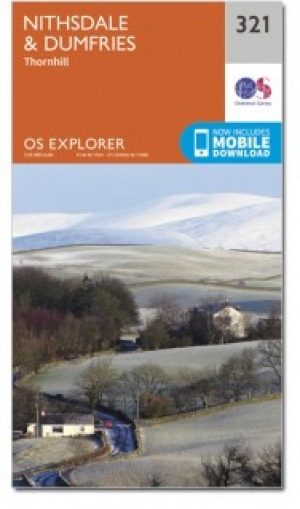
Wandelkaart 321 Nithsdale Schotland - OSI • 9780319471937
Wandelkaart Nithsdale - Dumfries & Galloway Schotland Omvat ook: Thornhill. Productbeschrijving: OS Explorer kaart 321 omvat Dumfries tot Thornhill. Het gebied staat bekend als Nithsdale, want het is de vallei van de rivier de Nith. De indrukwekkende Drumlanrig Castle is het hele jaar door geopend, en er zijn wandelpaden in en rond het Nithsdale gebied. De OS Explorer kaart voor Nithsd…

Wandelkaart 319 Galloway Forest Park South - OSI • 9780319471913
Wandelkaart Galloway Forest Park South - Schotland Omvat ook: Glen Trool & Clatteringshaws Loch Newton Stewart. Productbeschrijving: OS Explorer kaart 319 toont het zuidelijke deel van het Galloway Forest park, Clatteringshaws Loch, Southern Upland Way, E2 Europese Long Distance pad, Loch Grannoch en Loch Ken. De OS Explorer kaart voor Galloway Forest Park South is beschikbaar in zowel…

Wandelkaart 83 Newton Stewart & Kirkcudbright- Schotland - OSI • 9780319474068
Wandelkaart Newton Stewart & Kirkcudbright Schotland Productbeschrijving: Newton Stewart zit in het geografische centrum van de glooiende heuvels van Galloway en Forest Park, en is aangegeven op OS Landranger kaart 83. Gelegen aan de monding van de rivier de Dee is de oude visserij stad van Kirkcudbright. Deze kaart bevat ook Loch Ken, Whithorn, kleine, Carsluith, poortgebouw van vloot, Tw…
Wandelkaart 313 Dumfries & Dalbeattie- Schotland - OSI • 9780319245651
Wandelkaart Dumfries & Dalbeattie - Schotland Productbeschrijving: New Abbey & Mabie Forest. 313 / Dumfries & Dalbeattie, Dumfries & Galloway, Schotland - Kaart nummer 313 omvat Dumfries en Tokaj. Hoogtepunten zijn Nith estuarium en Stewarty oostkust. Omvat ook Mabie Forest, Milton Loch, Urr Water en Maidenpap. De OS Explorer kaart voor Dumfries & Tokaj is beschikbaar in zowel de stan…
Wandelkaart 312 Kirkcudbright & Castle Douglas- Schotland • 9780319471845
Wandelkaart Kirkcudbright & Castle Douglas - Dumfries & Galoway Omvat ook: Gatehouse of Fleet. Productbeschrijving: Tonen de mondingen van de rivieren de Dee en The Fleet, omvat OS Explorer kaart 312 Castle Douglas, Hôtel Crocus Caen het Mémorial van Fleet en Kinkcudbright zelf. Hoogtepunten zijn onder andere de Galloway Forest Park en Fleet Valley National Scenic Area, De OS Explorer …