

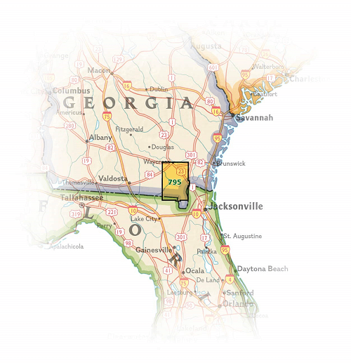
Wandelkaart 795 Okefenokee National Wildlife Refuge
Een 1,627 km² National Wildlife Refuge gelegen in Charlton

Korte omschrijving
Wandelkaarten Georgia, USA van National Geographic. Ideaal voor tochten in Verenigde Staten van Amerika (USA).
TOPO Wandelkaart 795 - Okefenokee National Wildlife Refuge - National Geographic Productomschrijving: Het Okefenokee National Wildlife Refuge is een 1,627 km² National Wildlife Refuge geleg...

Specificaties
- Uitgever: National Geographic
- ISBN-13: 9781566956277
- HOOFDCATEGORIEËN: Wandelkaart
- Auteur: National Geographic
- Regio: Georgia, USA
- Land: Verenigde Staten van Amerika (USA)
- Nationale parken: Okefenokee National Wildlife Refuge, Florida USA
- TOPO's & Stafkaarten: Topografisch wandelen
- Schaal: 1:63360
- Taal: Engels
Volledige omschrijving
TOPO Wandelkaart 795 - Okefenokee National Wildlife Refuge - National Geographic
Productomschrijving: Het Okefenokee National Wildlife Refuge is een 1,627 km² National Wildlife Refuge gelegen in Charlton, Ware en Clinch regio's in Georgia- en Baker County in Florida, United States.
Engelse omschrijving: Covering 630 square miles in southeast Georgia, the Okefenokee National Wildlife Refuge encompasses nearly all of the world-renowned Okefenokee Swamp. Expertly researched and created in partnership with local land management agencies, National Geographic's Trails Illustrated map of Okefenokee National Wildlife Refuge provides an unparalleled tool for exploring this magnificent wetland. This map offers unmatched detail of the entire park and features key areas of interest including Stephen C. Foster State Park; Suwannee River Sill Recreation Area; Okefenokee Swamp Park; Kingfisher Landing; and Laura S. Walker State Park.
Designed with a wide range of visitors in mind, this map features detailed topography with shaded relief and vegetation classification; accurate road network including Okefenokee Trail and Swamp Island Drive auto tours; visitor centers and facilities; safety tips; and agency contact information. Paddling is the best way to explore the refuge in depth, and this map is loaded with information specific to that activity including color-coded canoe trails, trail mileage, difficulty ratings, and charts of canoe trails and overnight canoe trips. Many recreation features are noted as well, including campgrounds, boat ramps, shooting ranges, and areas for wildlife viewing, water skiing, biking, paddling, fishing, and swimming. Every Trails Illustrated map is printed on "Backcountry Tough" waterproof, tear-resistant paper. A full UTM grid is printed on the map to aid with GPS navigation.
Other features found on this map include: Okefenokee Swamp.
Locatie op kaart
Artikelen uit dezelfde regio

Landkaart Wegenkaart Georgia State Guide maps - Nat Geo • 9781597754163
Wegenkaart Georgia State Guide maps - Nat Geo Productomschrijving: National Geographic's Georgia Guide Map provides travelers with the perfect combination of detail and perspective in a highly functional travel tool. A handy combination of map and guidebook, this map is loaded with information on historical, cultural, recreational, and ecological attractions. Cities and towns are easy to …
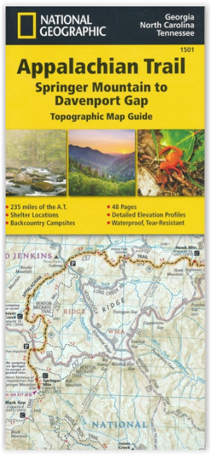
Wandelkaart 1501 Appalachian Trail - Deel 1 - Natgeo • 9781597756389
TOPO Wandelkaart 1501 - Springer Mt to Davenport Gap - Natgeo Productomschrijving: Deel 1 - 3500 km wonderbaarlijke route van Main tot in Atlan. Deze kaart omvat het eerste deel van 13 van Springer mountain tot aan Davenport Gap. Omvat de regio's Georgia, North Carolina & Tennessee. Engelse omschrijving: The Springer Mountain to Davenport Gap Topographic Map Guide makes a perfect trav…

Reisgids Georgia & the Carolinas - Lonely planet • 9781837584321
Georgia & the Carolinas - Lonely planet Productomscrijving: Breathtaking natural beauty, deeply hospitable people, quaint rural backwaters and cosmopolitan capitals make the South Caucasus region a thrilling, offbeat discovery. Lonely Planet will get you to the heart of Georgia & tge Carolinas with amazing travel experiences and the best planning advice. Lonely Planet Georgia, is your …