
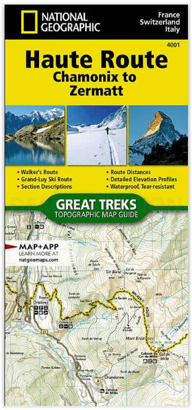
Wandelkaart 4001 Haute Route - Chamonix to Zermatt - Nat Geo
Haute Route from Chamonix France to Zermatt Switzerland
Korte omschrijving
Wandelkaarten Haute-S'avoie, Frankrijk en Valle d’Aosta, Italië van National Geographic. Ideaal voor tochten in Frankrijk, Italië en Zwitserland.
Haute Route - Chamonix to Zermatt - Nat Geo Productomschrijving: De Haute Route - ook wel de Hoge Route of Bergbeklimmersroute genoemd - doorkruist de Franse en Zwitserse Alpen. De route wer...

Specificaties
- Uitgever: National Geographic
- ISBN-13: 9781566958103
- HOOFDCATEGORIEËN: Wandelkaart
- Activiteiten: Wandelen, Hiking & Trekking
- Auteur: National Geographic
- Regio: Haute-S'avoie, Frankrijk, Valle d’Aosta, Italië
- Land: Frankrijk, Italië, Zwitserland
- TOPO's & Stafkaarten: Topografisch wandelen
- Schaal: 1:40000
- Taal: Engels
- Iconische Wandelroutes: Tour de Matterhorn, Zwitserland
Volledige omschrijving
Haute Route - Chamonix to Zermatt - Nat Geo
Productomschrijving: De Haute Route - ook wel de Hoge Route of Bergbeklimmersroute genoemd - doorkruist de Franse en Zwitserse Alpen. De route werd halverwege de negentiende eeuw door leden van de Engelse Alpine Club bedacht als een zomerbergbeklimmersroute. Hoewel oorspronkelijk "The High-Level Route" genoemd door leden van de Alpine Club, legde een groep in 1911 voor het eerst met succes een winterroute van Bourg St. Pierre naar Zermatt op ski's aan en daarna werd de naam van de route in het Frans vertaald.
Als gevolg van hun succes, bleef de Franse term hangen, en de tocht kreeg een reputatie onder skiërs en ski-bergbeklimmers als een klassieke must-do winter / voorjaar tour. Er is ook een niet-technische Walker's Haute Route die aan populariteit heeft gewonnen en een klassieker op zich is geworden.
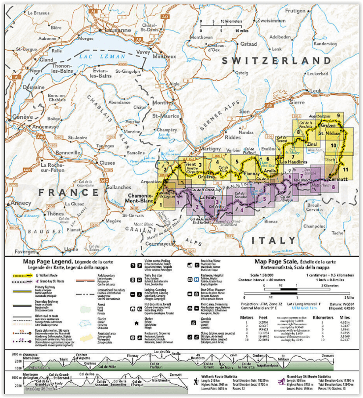
Deze Topografische Kaart Gids schetst twee verschillende varianten van de Haute Route van Chamonix, Frankrijk naar Zermatt, Zwitserland, een voor wandelaars en een voor skiërs. De meest noordelijke route of, Walker's Route, afgebeeld op de kaart reist noordwaarts van Chamonix en doorkruist de Alpen helemaal tot Zermatt. De skiroute die op deze kaart is afgebeeld, illustreert de Grand Lui variant, de langste en meest technische route die de wegverbindingen van de Verbier en Classic varianten elimineert.
Engelse omschrijving: The Haute Route—aka the High Route or Mountaineers' Route—traverses the French and Swiss Alps. It was conceived as a summer mountaineering route in the mid-nineteenth century by members of the English Alpine Club. Though originally called "The High-Level Route" by members of the Alpine Club, in 1911, a group first successfully established a winter route from Bourg St. Pierre to Zermatt on skis and afterwards the name of the route was translated into French. As a result of their success, the French term stuck, and the journey gained a reputation amid skiers and ski mountaineers as a classic must-do winter/spring tour. There is also a non-technical Walker's Haute Route that has gained in popularity and become a classic in and of itself.
This Topographic Map Guide outlines two different variations of the Haute Route from Chamonix, France to Zermatt, Switzerland, one for hikers and one for skiers. The northernmost route or, Walker's Route, depicted on the map travels north from Chamonix and traverses through the Alps all the way to Zermatt. The ski route depicted on this map illustrates the Grand Lui variation, which is the longest and most technical route that eliminates the road links of the Verbier and Classic variations.
Though the term Haute Route has been widely used for many multi-day, hut-to-hut alpine tours, the "Chamonix–Zermatt Haute Route" remains the original. Thus, whether you choose to wear skis or hiking boots, the Haute Route is an adventure unlike any other.
More convenient and easier to use than folded maps, but just as compact and lightweight, National Geographic’s Topographic Map Guide booklets are printed on "Backcountry Tough" waterproof, tear-resistant paper with stainless steel staples. A full UTM grid is printed on the map to aid with GPS navigation.

Artikelen uit dezelfde regio

Wandelgids Carnet d'aventure, GTA - Chamina Ed. • 9782844667182
Wandelgids Carnet d'aventure, La Grande Traversee Des Alpes Franse productomschrijving: Carnet d’aventure - Grande Traversée des Alpes » : un carnet de voyage profondément humain au cœur des Alpes. À travers les récits croisés de quatre auteurs – jeunes rêveurs, retraité passionné ou aventurière en quête d’elle-même, ce carnet d’aventure "La Grande Traversée des Alpes" vous embarque da…
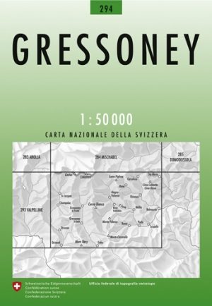
Wandelkaart 294 Gressoney Valle d'Aoste - Swisstopo • 9783302002941
Wandelkaart Gressoney - Valle d'Aoste Italië - Swisstopo Productomschrijving: Gressoney-La-Trinité is een gemeente in de Italiaanse provincie Valle d'Aosta. Gressoney-La-Trinité grenst aan de volgende gemeenten: Alagna Valsesia, Ayas, Gressoney-Saint-Jean, Riva Valdobbil & Zermatt zwitserland. Detail: Zeer gedetailleerde topografische wandelkaarten van een klein stuke Zwitserland met s…
Wandelgids 100 sommets des Alpes du Nord - Glénat • 9782344027691
Wandelgids -100 sommets des Alpes du Nord - Glénat Productomschrijving: Welkom boven de symbolische grens van de 3000 meter hoogte en in het prestigieuze domein van de hoge bergen, traditioneel gereserveerd voor bergbeklimmers. Voor wandelaars, enthousiastellingen van een sportieve en veeleisende wandelingen, die de flair van de goede passages en de zekere voetvbaste situatie vereist, bied…
Wandelkaart 292 Courmayeur Valle d'Aoste - Swisstopo • 9783302002927
Wandelkaart Courmayeur - Valle d'Aoste Italië - Swisstopo Productomschrijving: Courmayeur is een plaats met bijbehorende gemeente in de Italiaanse provincie Valle d'Aosta. De gemeente omvat de dalen Val Ferret en Val Veny die langs het Mont Blancmassief lopen. Waar de rivieren uit de twee dalen, de Dora di Ferret en de Dora di Veny, samenkomen, bij Entrèves ontstaat de Dora Baltea, de hoof…

Wandelgids Walliser Alpen - SAC • 9783859023963
Wandelgids Walliser Alpen Omvat: Mont Dolent- Grand Combin & Pigne d'Arolla Productomschrijving: Deze Alpine bergwandelgids is gewijd aan de tweede Wallis regio's. Het bevat veilige en lonende wandel routes op een aanzienlijk aantal prachtige bergen werden veel dichter bij de bewoners van de noordelijke Alpen verplaatst. Hij begint met de machtige uitlopers van de Mont Blanc en eindig…