

Wandelkaart 351 Lefkada - Terrain Maps
Met omliggende Eilanden Kefalonia- Ithaka & Meganisi

Korte omschrijving
Wandelkaarten Ionische Eilanden, Griekenland van Terrain Editions. Ideaal voor tochten in Griekenland.
Wandelkaart Lefkada - Terrain maps Productomschrijving: Lefkada is een Grieks eiland, zeg maar schiereiland, in de Ionische Zee, verbonden met het vasteland via een pontonbrug. Er is ook een...

Specificaties
- Uitgever: Terrain Editions
- ISBN-13: 9786185160258
- HOOFDCATEGORIEËN: Wandelkaart
- Activiteiten: Wandelen, Hiking & Trekking
- Regio: Ionische Eilanden, Griekenland
- Land: Griekenland
- Waterafstotende kaart: Terrain editions WP
- Departement: Nomos, Griekenland
- Schaal: 1:45000
- Taal: Engels
Volledige omschrijving
Wandelkaart Lefkada - Terrain maps
Productomschrijving: Lefkada is een Grieks eiland, zeg maar schiereiland, in de Ionische Zee, verbonden met het vasteland via een pontonbrug. Er is ook een verbinding mogelijk met een veerboot met de andere Ionische Eilanden Kefalonia, Ithaka en Meganisi. Deze kaart omvat het schiereiland zelf, en alle routes beschikbaar.

Locatie op kaart
Overzichtskaarten

Terrain Editions Wandelkaarten Griekse eilanden
Terrain Editions Wandelkaarten Griekse eilanden
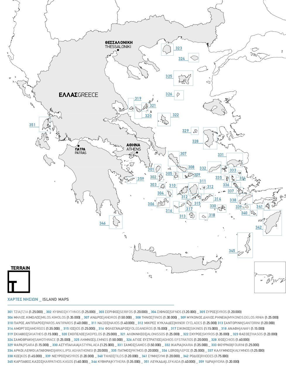
Producten op de overzichtskaart
Klik op een product om naar de detailpagina te gaan.
- Wandelkaart 305 Syros Griekenland - Terrein Editions
- Wandelkaart 310 Paros & Antiparos - Terrein Maps
- Wandelkaart 311 Naxos Griekenland - Terrein Maps
- Wandelkaart 312 Cyclades minora - Terrein Maps
- Wandelkaart 313 Santorini Griekenland - Terrein Maps
- Wandelkaart 314 Amorgos Griekenland - Terrain Maps
- Wandelkaart 315 Ios Griekenland - Terrein Maps
- Wandelkaart 316 Folegandros Griekenland - Terrain ed.
- Wandelkaart 317 Sikinos Griekenland - Terrein Editions
- Wandelkaart 318 Anafi Griekenland - Terrein Maps
- Wandelkaart 319 Skiathos Griekenland - Terrein Maps
- Wandelkaart 320 Skopelos Griekenland - Terrein Maps
- Wandelkaart 321 Nisos- Alonnisos - Terrein Maps
- Wandelkaart 322 Skyros- Noordelijke Sporaden - Terrein Maps
- Wandelkaart 323 Thassos Griekenland - Terrein Maps
- Wandelkaart 324 Samothrace Samothraki - Terrain maps
- Wandelkaart 325 Lemnos Griekenland - Terrein Maps
- Wandelkaart 326 Aghios Efstratios - Terrein Maps
- Wandelkaart 328 Chios Griekenland - Terrein Maps
- Wandelkaart 329 Psara Griekenland - Terrein Maps
- Wandelkaart 330 Astypalaea eiland Griekenland - Terrain maps
- Wandelkaart 331 Samos Griekenland - Terrain maps
- Wandelkaart 332 Ikaria Griekenland - Terrein Maps
- Wandelkaart 333 Fourni Eilanden - Terrein Maps
- Wandelkaart 334 Arki- Lipsi & Aghathonisi - Terrein Maps
- Wandelkaart 335 Patmos Griekenland - Terrein Maps
- Wandelkaart 337 Kalymnos Griekenland - Terrein Maps
- Wandelkaart 338 Kos Griekenland - Terrein Maps
- Wandelkaart 339 Nisyros Griekenland - Terrein Maps
- Wandelkaart 340 Tilos Griekenland - Terrein Maps
- Wandelkaart 341 Symi Griekenland - Terrein Maps
- Wandelkaart 342 Rhodos Griekenland - Terrein Maps
- Wandelkaart 345 Karpathos & Kasos - Terrain Maps
- Wandelkaart 346 Kythera Griekenland - Terrein Maps
- Wandelkaart 351 Lefkada - Terrain Maps
- Wandelkaart 359 Hydra- Saronische eilanden - Terrein maps
Artikelen uit dezelfde regio
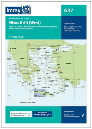
Passage kaart G37 Nísos Kríti (West) - Imray (F&B) • 9781846239359
Passagekaart Nísos Kríti (West) - Imray (F&B) Productomschrijving: Voor deze editie zijn magnetische variatiecurves toegevoegd. De kaart is volledig geactualiseerd.. (Freytag & Berndt) - 1:193.000 Kaart omvat: Het westelijke deel van het eiland Nisos Kriti (Kreta), van Iraklion tot het westelijke puntje. Schaal: 1 : 193.000. Grotere schaalplannen van Ormos Gramvousa, Hania, Rethimno,…
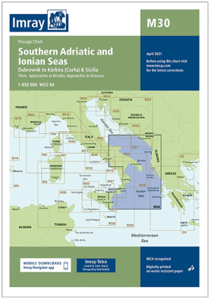
Passagekaart M30 Zuid Adriatische Zee en Ionische Zee - Imray • 9781846236860
Passagekaart Zuidelijke Adriatische Zee en Ionische Zee - Imray Productomschrijving: De zuidelijke Adriatische Zee en de Ionische Zee, die onze Adriatische kaartenserie verbindt met zowel onze Griekse serie als onze toekomstige Italiaanse serie. Met Dubrovnik tot Kérkira (Corfu) en Sicilië Op schaal 1: 850.000 De Imray Charts M-serie bestrijken het Middellandse Zee gebied, en biedt…

Reisgids pocket gids Zakynthos & Kefallonia - Marco Polo (NL) • 9783829742368
Reisgids Zakynthos & Kefallonia - Marco Polo Productomschrijving: Marco Polo reisgids voor de Ionische eilanden Zákinthos, Kefalloniá en Léfkas. Handig pocket formaat, boordevol informatie, met uitneembare kaart van de eilanden en 8 bladzijden atlas. Met 'insider tips' om de eilanden écht te ontdekken, de TOP 15 van bezienswaardigheden in één oogopslag, up-to-date informatie in overzichte…
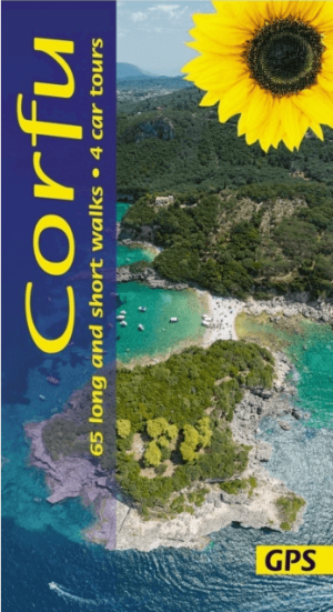
Wandelgids Corfu Griekenland - Sunflower Books • 9781856915618
Wandelgids Corfu - Sunflower Books Productomschrijving: The book focuses on walking in Corfu, but it is not intended only for walkers. The touring section will also show you the best of Corfu by car, and the picnic suggestions make an excellent introduction to the countryside. This Eighth edition has been completely revised just prior to publication, with many new walks (there are now…

Reisgids Zakynthos & Kefalonia islands (ENG) - Marco Polo • 9781914515576
The Zakynthos, Kefalonia, Ithaca & Lefkada Islands Greece Productomschrijving: Let Marco Polo Zakynthos and Kefalonia guide you around these beautiful Greek islands! Explore Zakynthos and Kefalonia with this handy, pocket-sized, authoritative guide, packed with Insider Tips. Discover boutique hotels, authentic restaurants, the islands’ trendiest places, and get tips on shopping, what…