

Wandelkaart 215 Glacier & Waterton Lakes NP - Montana - Nat Geo
Glacier NP sluit nadeloos aan op het Canadese Waterten Lakes NP

Korte omschrijving
Wandelkaarten Montana, USA en Alberta, Canada van National Geographic. Ideaal voor tochten in Verenigde Staten van Amerika (USA) en Canada.
TOPO Wandelkaart 215 - Glacier & Waterton Lakes NP Productomschrijving: Glacier National Park is een nationaal park in de Amerikaanse staat Montana. Het park sluit nadeloos aan op het Canade...

Specificaties
- Uitgever: National Geographic
- ISBN-13: 9781566953184
- HOOFDCATEGORIEËN: Wandelkaart
- Activiteiten: Wandelen, Hiking & Trekking
- Auteur: National Geographic
- Regio: Alberta, Canada, Montana, USA
- Land: Canada, Verenigde Staten van Amerika (USA)
- Nationale parken: Wateron Lakes NP Alberta Canada
- TOPO's & Stafkaarten: Topografisch wandelen
- Schaal: 1:100000
- Taal: Engels
Volledige omschrijving
TOPO Wandelkaart 215 - Glacier & Waterton Lakes NP
Productomschrijving: Glacier National Park is een nationaal park in de Amerikaanse staat Montana. Het park sluit nadeloos aan op het Canadese Waterten Lakes NP net over de grens in Alberta Canada. Het park ligt in de Rocky Mountains op de grens met Canada. Zes bergtoppen bereiken er een hoogte van meer dan 3000 meter.
Engelse omschrijving: National Geographic's Trails Illustrated map of Glacier and Waterton Lakes National Parks offers unparalleled detail for outdoor enthusiasts exploring the pristine landscape of forests, mountains, lakes, and meadows within these two spectacular parks. Created in partnership with local land management agencies, this expertly researched map features key areas of interest including Many Glacier, Great Bear Wilderness, Flathead National Forest, Hungry Horse Reservoir, Lake McDonald, Flathead River, St. Mary Lake, Akamina-Kishinena Provincial Park, and the Waterton Lakes.
The Glacier and Waterton Lakes map is an invaluable resource for exploring the more than 800 miles of mapped trails within the parks, including the Pacific Northwest Trail, the Continental Divide Trail, and recommended biking trails. Recreation features are clearly marked, including campgrounds, trailheads, interpretive trails, fishing and boat access, and horse rental locations. The map base includes contour lines and elevations for summits, passes and major lakes. A variety of helpful information about recreation activities available in the parks, hiking and backcountry camping, regulations, and safety tips are included as well. Every Trails Illustrated map is printed on "Backcountry Tough" waterproof, tear-resistant paper. A full UTM grid is printed on the map to aid with GPS navigation.
Other features found on this map include: Apgar Mountains, Bowman Lake, Flathead National Forest, Flathead Range, Glacier, Great Bear Wilderness, Kintla Lake, Lake McDonald, Lake Sherburne, Lewis & Clark National Forest, Lewis Range, Livingston Range, Lower Saint Mary Lake, Mount Carter, Mount Cleveland, Mount Saint Nicholas, Mount Stimson, Saint Mary Lake, Upper Waterton Lake, Whitefish Lake.
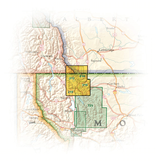
Locatie op kaart
Overzichtskaarten

NAT GEO Montana trails map
NAT GEO Montana trails map

Producten op de overzichtskaart
Klik op een product om naar de detailpagina te gaan.
Artikelen uit dezelfde regio
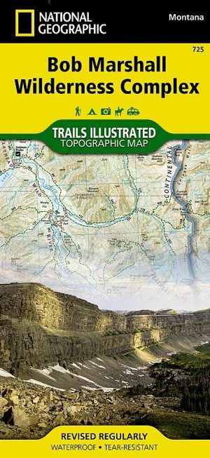
Wandelkaart 725 Bob Marshall Wilderness - Natgeo • 9781597756266
TOPO Wandelkaart 725 - Bob Marshall Wilderness - Natgeo Productomschrijving: The Bob Marshall Wilderness Area is een op kaart gemaakte wilderness area gelegen in western Montana in de United States. Dit wildernis, samen met de aanpalende bossen Scapegoat- en Great Bear wildernes, maken samen het "Bob Marshall Wilderness Complex". Engelse omschrijving: Located just north of Yellowstone…

Reisgids West Canada (ENG) - Marco Polo • 9781914515934
Reisgids West Canada - Marco Polo Productomschrijving: Let Marco Polo Canada West guide you around this beautiful region. Explore Western Canada with this handy, pocket-sized, authoritative guide, packed with Insider Tips. Discover boutique hotels, authentic restaurants, the region's trendiest places, and get tips on shopping and what to do on a limited budget. There are plenty of ide…
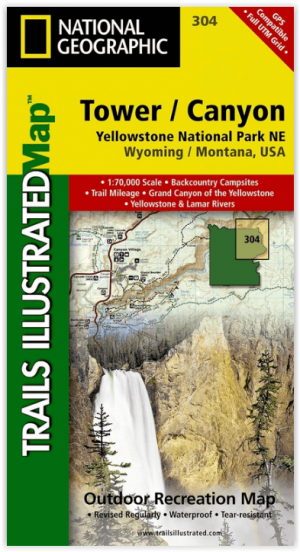
Wandelkaart 304 Tower & Canyon Yellowstone NP - Nat Geo • 9781566954358
TOPO Wandelkaart 304 - Tower & Canyon Yellowstone NP - Natgeo Productomschrijving: Deze hoeft geen uitleg, het is de thuis van de mooiste natuurlijke sites die de wereld in petto heeft, en de thuis van El Capitan, de kilometer hoge granieten steen wereldbekend door de klimmers. Kortom, een Nationaal park van formaat die iedereen kent de wereld rond. Engelse omschrijving: National Geogr…
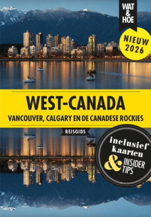
Reisgids Wat & Hoe West Canada - Kosmos • 9789043942690
Reisgids Wat & Hoe West Canada - Kosmos Productomschrijving: Met deze Wat & Hoe Reisgids West-Canada ga je voorbereid onderweg. Bezoek het multiculturele Vancouver, ontdek de moderne architectuur van Calgary of trek door de Canadese Rocky Mountains in. Ook de prachtige nationale parken van Canada, zoals Banff of Jasper, zijn het bezoeken meer dan waard. Wat krijg je: Een gids met p…

Wandelkaart 201 Yellowstone NP- Wyoming - Nat Geo • 9781566952958
TOPO Wandelkaart 201 - Yellowstone NP- Wyoming - Nat geo Productomschrijving: Yellowstone National Park, wat een prachtig concept voor een nationaal park, een par van formaat, en een nationaal park in de Verenigde Staten, hoofdzakelijk in Wyoming, maar met kleine gedeeltes in de aangrenzende staten Montana en Idaho. Engelse omschrijving: National Geographic's Trails Illustrated map of …