

Land
- Albanië (7)
- Andorra (3)
- Armenië (1)
- Azoren (1)
- België (138)
- Bosnië-Herzegovina (1)
- Bulgarije (1)
- Cyprus (3)
- Denemarken (8)
- Dominica (1)
- Duitsland (231)
- Engeland (1)
- England (235)
- Estland, Baltische staten (1)
- Europa (14)
- Faroe Islands, Denemarken (2)
- Finland (4)
Regio
- A Coruña (provincie) Galicië Spanje (2)
- Aargau, Zwitserland (1)
- Aberdeenshire, Schotland (1)
- Abisko, Zweden (1)
- Abruzzo, Italië (2)
- Achterhoek NW, Nederland (2)
- Adriatische Zee (1)
- Adriatische kust (1)
- Ajaccio, Corsica (1)
- Albanië (1)
- Alentejo, Portugal (1)
- Algarve, Portugal (10)
- Allgäu, Duitsland (10)
- Almens, Zwitserland (1)
- Alpengebied (3)
- Alpes-de-Haute-Provence, Frankrijk (2)
- Alsace, Frankrijk (7)
- Altmühltal, bayern (1)
- Andalusië, Spanje (9)
- Anglesey, Wales (1)
- Antwerpen, België (3)
- Antwerpse Kempen, België (1)
- Aoste, Italië (5)
- Aquitaine, Frankrijk (7)
- Aragon, Espagne (5)
- Aragón, Spanje (3)
- Ardennen, België (7)
- Ardèche, Frankrijk (2)
- Arendal, Zuid-Noorwegen (1)
- Argyll & Bute, Schotland (3)
- Ariège, Frankrijk (1)
- Arlberg, Oostenrijk (1)
- Armenië, Azië (1)
- Asturië (provincie) Spanje (11)
- Auvergne Sud, Frankrijk (2)
- Auvergne, Frankrijk (7)
- Auvergne-Rhône-Alpes, Frankrijk (202)
- Avebury, England (1)
- Ayent, Zwitserland (1)
- Azoren, Portugal (3)
- Baden bei Zürich, Zwitserland (2)
- Baden-Württemberg, Duitsland (22)
- Balearen, Spanje (10)
- Balkan, Zuid-Europa (5)
- Baltische staten, Europa (2)
- Bas-Rhin, Frankrijk (2)
- Basilicata, Italië (1)
- Basse-Normadie, Frankrijk (1)
- Bayern of Beieren, Duitsland (30)
- Bayrische Alpen, Duitsland (1)
- Bedfordshire, England (2)
- Beieren, Duitsland (29)
- Belgisch Eifel gebied (1)
- Belgisch Limburg (1)
- Belgisch Lotharingen (1)
- België (4)
- Benelux (2)
- Berchtesgaden, Duitsland (1)
- Berkshire South West England (3)
- Berlijn, Duitsland (3)
- Bern, Zwitserland (14)
- Bern;µ, Zwitserland (1)
- Berner Oberland (1)
- Berner, Zwitserland (1)
- Bernese Hooglanden, Zwitserland (1)
- Binnen Hybriden (Inner Hybrids), Schotland (1)
- Bodensee, Duitsland (1)
- Boheemse en Saksische Zwitserland (1)
- Bohuslän, Zweden (1)
- Bolzano, Italië (2)
- Bordeaux, Frankrijk (1)
- Borders Eastern Schotland (1)
- Bosnie-Herzégovine (1)
- Bouches-du-Rhône, Frankrijk (1)
- Bourgogne, Frankrijk (2)
- Bourgogne-Franche-Comté, Frankrijk (37)
- Bournmouth, England (1)
- Bozen, Zuid Tirol, Oostenrijk (1)
- Brabant, België (5)
- Brabant, Nederland (1)
- Brandenburg, Duitsland (2)
- Bremen (1)
- Bretagne, Frankrijk (79)
- Bristol, England (1)
- Brussel, België (4)
- Buckinghamshire, England (2)
- Bürgenland, Oostenrijk (1)
- Calabrië, Italië (2)
- Cambridgeshire, England (1)
- Campanië, Italië (2)
- Canarische Eilanden (25)
- Canarische Eilanden, Spanje (13)
- Cantabrisch gebergte, Spanje (4)
- Cantabrië (provincie) Spanje (2)
- Cantabrië, Spanje (6)
- Cardiff, Wales (2)
- Carinthia (1)
- Castilië León, Spanje (1)
- Castilië y León, Spanje (3)
- Castilla y León, Spanje (2)
- Catalonië (Regio) Spanje (4)
- Centraal Massief, Frankrijk (4)
- Centraal Noorwegen (1)
- Centraal Portugal (1)
- Centraal Schotland (1)
- Centraal Zwitserland (3)
- Central Eastern Schotland (1)
- Central England (1)
- Central Wales (1)
- Centrale Pyreneeën, Frankrijk (1)
- Centre Val de Loire, Frankrijk (6)
- Ceredigion, South Wales (1)
- Champagne Ardennes, Frankrijk (4)
- Channel Islands, England (1)
- Cheshire, England (3)
- Cinque Terre, Italië (1)
- Clermont-Ferrand (1)
- Collonges (1)
- Como, Italië (1)
- Cornwall, England (7)
- Corsica Sud, Frankrijk (2)
- Corsica, Frankrijk (33)
- Costa Blanca, Spanje (5)
- Costa Brava, Spanje (1)
- Costa Del Sol, Spanje (2)
- Costa Verde, Portugal (1)
- County Durham, Ierland (1)
- County Kerry, Ireland (3)
- County Wicklow, Ireland (1)
- Cowny County, Wales (1)
- Cresciano, Zwitserland (1)
- Cugnasco, Zwitserland (1)
- Cumbria & Lake District, England (22)
- Cumbria, England (16)
- Cycladen Zuid, Griekenland (2)
- Cycladen, Griekenland (1)
- Cévennes, Frankrijk (1)
- Dalarna, Zweden (2)
- Dalmatische Kust, Kroatië (2)
- Derbyshire & Peak District, England (14)
- Derbyshire, England (2)
- Devon, England (16)
- Diapontische eilanden, Griekenland (1)
- Dodecanesos, Griekenland (1)
- Dodekanesos eilanden, Griekenland (1)
- Dolomieten, Italië (4)
- Dorset, England (6)
- Drenthe, Nederland (2)
- Dresden, Duitsland (1)
- Duitse Alpen gebied (5)
- Duitsland (2)
- Dumfries & Galloway, Schotland (4)
- Durham, England (1)
- East Anglia, England (2)
- East Dunbartonshire, Schotland (1)
- East England (2)
- East Midlands, England (2)
- East Schotland (1)
- East Sussex, England (2)
- Eastern Highlands, Schotland (1)
- Eastern Ireland (1)
- Edinburgh West Schotland (3)
- Egeische eilanden, Griekenland (7)
- Eifel regio, Duitsland (1)
- Eifel, Duitsland (2)
- El Hiero, Canarische eilanden Spanje (2)
- Elzas, Frankrijk (5)
- Emilia-Romagna, Italië (2)
- Engeland (11)
- Epirus, Griekenland (1)
- Essen, Duitsland (1)
- Essex South England (2)
- Estremadura, Portugal (1)
- Europa (7)
- Extremadura, Portugal (2)
- Faroe Islands - Faroer Eilanden, Denemarken (2)
- Fife, Schotland (2)
- Finland (1)
- Finnmark, Noorwegen (1)
- Flevoland, Nederland (1)
- Formentera, Spanje (1)
- Franche Comté, Frankrijk (2)
- Franken, Duitsland (6)
- Frankrijk (9)
- Frans Baskenland, Frankrijk (8)
- Franse Alpen (2)
- Franse Pyreneeën, Frankrijk (2)
- Fribourg, Zwitserland (2)
- Friesland Oost, Nederland (1)
- Friesland, Nederland (5)
- Friuli, Italië (2)
- Friuli-Venezia Giulia, Italië (2)
- Fuerteventura, Canarische eilanden, Spanje (4)
- Galicië, Spanje (18)
- Gelderland, Nederland (10)
- Gelderse Ijsel, NEderland (1)
- Geneva, Zwitserland (1)
- Gent, Oost-Vlaanderen (2)
- Genua, Italiaaanse riviera (1)
- Genève, Zwitserland (2)
- Gers, Frankrijk (1)
- Glarus Süd, Zwitserland (1)
- Glasgow, Schotland (1)
- Gloucestershire, Egland (11)
- Gorenjska, Slovenië (1)
- Gotland, Zweden (1)
- Gower Peninsula, Wales (1)
- Gran Canaria Las Palmas (1)
- Gran Canaria Las Palmas, Canarische eilanden Spanje (5)
- Grand Est, France (29)
- Graubünden noord, Zwitserland (1)
- Graubünden, Zwitserland (12)
- Greater London, England (7)
- Greater Manchester, England (1)
- Griekse eilanden (2)
- Groene hart Nederland (1)
- Groningen, Nederland (3)
- Grövelsjön, Zweden (1)
- Gwynedd, Wales (2)
- Göschenen, Zwitserland (2)
- Hainaut / Henegouwen, België (1)
- Hamburg, Duitsland (2)
- Hampshire, England (5)
- Hamry, Tsjechië (1)
- Hardangervidda, Noorwegen (1)
- Harz mountains, Duitsland (3)
- Harz, Duitsland (1)
- Haute-Normandie, Frankrijk (5)
- Haute-S'avoie, Frankrijk (7)
- Hauts-de-France, Frankrijk (12)
- Helgeland, Noorwegen (1)
- Hemavan, Zweden (1)
- Henegouwen, België (1)
- Hereford, England (2)
- Herefordshire, England (2)
- Hertfordshire East England (1)
- Hessen, Duitsland (15)
- Highlands Noord, Schotland (1)
- Highlands, Schotland (24)
- Hoek van Holland, Nederland (1)
- Hovedstaden, Denemarken (1)
- Hradec Králové, Tsjechië (1)
- Huesca (Provincie) Spanje (2)
- Huesca, Spanje (2)
- Hunsruck, Duitsland (2)
- IJsland (4)
- Ibiza, Balearen Spanje (1)
- Ierland (6)
- Ierse Zee (2)
- Inner hybrids (Binnen-Hebriden), Schotland (4)
- Innerrhoden (1)
- Innlandet, Noorwegen (1)
- Innsbruck, Oostenrijk (1)
- Ionische Eilanden, Griekenland (6)
- Isle of Harris, Outer Hybrid's Schotland (1)
- Isle of Lewis, Outer Hybrid's Schotland (1)
- Isle of Man (1)
- Isle of Mull, Inner Hybrids Schotland (1)
- Isle of Scilly (1)
- Isle of White, Engeland (4)
- Isle of sky, Schotland (4)
- Istrië, Kroatië (1)
- Isère, Frankrijk (6)
- Italiaanse Alpen (2)
- Italiaanse meren (1)
- Italië (5)
- Jersey, Kanaaleilanden (1)
- Julische Alpen (1)
- Julische Alpen, Slovenië (1)
- Jura, Frankrijk (5)
- Jutland, Denemarken (4)
- Kainuu, Finland (1)
- Karavanken, Slovenië (1)
- Karinthië, Oostenrijk (12)
- Kempen, België (1)
- Kent South East England (5)
- Kerkira, Griekenland (1)
- Korfoe, Griekenland (1)
- Kosovo, Balkan Zuid-Europa (1)
- Kreta, Balearen Spanje (1)
- Kristiansand, Zuid-Noorwegen (1)
- La Chapelle-d'Abondance, Frankrijk (1)
- La Gomera, Spanje (4)
- La Palma, Canarische eilanden Spanje (6)
- Lac de Genève, Zwitserland (1)
- Lanacshire, England (8)
- Landes, Frankrijk (1)
- Languedoc-Roussillon, Frankrijk (18)
- Lanzarote, Canarische eilanden, Spanje (4)
- Lapland (4)
- Lapland, Finland (2)
- Lapland, Noorwegen (1)
- Lapland, Zweden (3)
- Las Palmas, Canarische eilanden, Spanje (1)
- Lauterbrunnen, Zwitserland (1)
- Lazio, Rome (1)
- Lazzio, Rome Italië (6)
- Leipzig, Duitsalnd (1)
- Lichtenstein, Duitsland (1)
- Ligurië, Italië (2)
- Lille, Frankrijk (2)
- Limburg (ned) (6)
- Limousin, Frankrijk (2)
- Lindesnes, Zuid-Noorwegen (1)
- Lissabon, Portugal (1)
- Liège / Luik, België (2)
- Lleyn, Wales (1)
- Loch Lomond, Schotland (1)
- Lofoten, Noorwegen (5)
- Loire centre, Frankrijk (1)
- Loire, Frankrijk (1)
- Lombardije, Italië (8)
- Lorraine, Frankrijk (3)
- Lotharingen (1)
- Lowland Scotland & Borders (2)
- Lozère, Frankrijk (1)
- Luxemburg (4)
- Luxemburg (Provincie) (11)
- Lyon, Frankrijk (2)
- Madeira, Portugal (8)
- Mallorca (2)
- Marken, Italië (1)
- Marseille, Frankrijk (1)
- Mecklenburg-Voor-Pommeren, Duitsland (2)
- Meer van Genève Oost, Zwitserland (1)
- Meer van Genève, Zwitserland (1)
- Meer van Luzern, Zwitserland (1)
- Menorca, Balearen Spanje (2)
- Merseyside, England (2)
- Mesocco (1)
- Middenlandse zee (8)
- Midi-Pyrénées, Frankrijk (9)
- Midlands, England (3)
- Moezel rivier (2)
- Montenegro, Balkan (1)
- Mullerthal, Luxemburgs Klein Zwitserland (1)
- Munchen, Duitsland (1)
- Munsterland, Duitsland (1)
- Møre og Romsdal, West-Noorwegen (1)
- Namur, België (3)
- Nantes, Frankrijk (2)
- Narvik, Noorwegen (1)
- Navarra (provincie) Spanje (1)
- Navarra, Espagne (4)
- Neder-Silezië, Polen (1)
- Nederland (4)
- Nederlands Limburg, Nederland (2)
- Newcastle, England (2)
- Nice, Frankrijk (1)
- Niedersachen, Duitsland (6)
- Niedersächen, Duitsland (6)
- NiederÖstenreich (3)
- NiederÖsterreich, Oostenrijk (9)
- Noord Bohemia, Tsjechië (1)
- Noord Brabant, Nederland (4)
- Noord Duitsland (1)
- Noord Engeland (5)
- Noord Graubunden, Duitsland (1)
- Noord Holland, Nederland (5)
- Noord Ierland (1)
- Noord Noorwegen (1)
- Noord Oost Schotland (1)
- Noord Polen (1)
- Noord Portugal (2)
- Noord Schotland (1)
- Noord Spanje (2)
- Noordrhein Westfalen, Duitsland (7)
- Noordrhein-Westfalen, Duitsland (13)
- Noorwegen (5)
- Nord-Pas-de-Calais, Frankrijk (5)
- Nordland, Noorwegen (2)
- Nordland, Zweden (1)
- Nordrhein-Westfalen (4)
- Norfolk East England (4)
- Normandië, Frankrijk (28)
- Norrbottens län, Zweden (3)
- Nort West Wales (1)
- North & North East England (13)
- North East England (3)
- North England (2)
- North Wales (8)
- North West England (11)
- North West Wales (1)
- North Yorkshire, Engeland (7)
- Northern Highland's, Schotland (6)
- Northern Ireland, UK (2)
- Northern Schotland, Highlands & Islands (2)
- Northhamshire, Engeland (1)
- Northhumberland North England (1)
- Northhumberland, North England (2)
- Northumberland, Engeland (10)
- Nottinghamshire, Engeland (1)
- Nouvelle-Aquitaine - Bassin Aquitain, Frankrijk (1)
- Nouvelle-Aquitaine, Frankrijk (58)
- Oberbayern, Duitsland (3)
- Oberfranken, Duitsland (1)
- Oberwald, Zwitserland (2)
- Oberöstenreich, Oostenrijk (6)
- Occitanië, Frankrijk (115)
- Ofotfjorden, Noorwegen (1)
- Oost Steiermark, Oostenrijk (1)
- Oost-Vlaanderen, België (3)
- Oost-Zwitserland (2)
- Oostenrijk (1)
- Oostkantons, België (1)
- Oostseekust, Duitsland (1)
- Opper-Beieren, Duitsland (1)
- Oppland, Noorwegen (1)
- Orkney Islands (3)
- Oslo (1)
- Ostallgäu, Duitsland (1)
- Ostkarpaten, Roemenië (1)
- Outer Hibrids, Schotland (3)
- Outer Hybrids, (Buiten Hybriden) Schotland (1)
- Overijssel Oost (2)
- Overijssel West (2)
- Overijssel, Nederland (5)
- Oxfordshire West England (1)
- Oxfordshire west England (5)
- Palagnedra (1)
- Pays-de-la-Loire, Frankrijk (19)
- Peak District (1)
- Peloponnesos, Griekenland (1)
- Peloponnessos (3)
- Peloponnessos, Griekenland (2)
- Pembrokeshire, Wales (3)
- Pen y Fan, Wales (1)
- Pentland Hills, Schotland (1)
- Perthshire, Schotland (2)
- Perugia, Umbrië Italië (1)
- Picardië, Frankrijk (4)
- Piemonte, Italië (8)
- Polen (1)
- Porto, Portugal (2)
- Portugal (8)
- Powys, Wales (2)
- Provence (1)
- Provence, Alpes-Côte D'azur, Frankrijk (40)
- Provence-Alpes-Côte d’Azur (29)
- Puglia, Italië (1)
- Puschlavs (1)
- Pyreneeën, Frankrijk (11)
- Radovljica (1)
- Realp (1)
- Rhône-Alpes (7)
- Rhône-Alpes, Frankrijk (5)
- Rijnland-Palts, Duitsland (3)
- Rijnland-Pfaltz, Duitsland (3)
- Rome (1)
- Saanen (1)
- Saarland (2)
- Saas-Almagell (1)
- Saksen (6)
- Saksen, Duitsland (4)
- Saksen-Anhalt (4)
- Salamanca, Spanje (1)
- Salerno (1)
- Salzburg (4)
- Salzburg, Duitsland (1)
- Salzburg, Oostenrijk (11)
- Salzburgerland (3)
- Salzkammergut, Oostenrijk (1)
- Samos, Griekenland (1)
- Sankt-Gallen, Zwitserland (3)
- Santiago de Compostela (gemeente) A Coruna Glaicië (2)
- Santiago de Compostella (3)
- Santorini, Griekenland (1)
- Sardinië, Italië (6)
- Sauerland, Duitsland (2)
- Scandinavië (2)
- Schaffhausen, Zwitserland (1)
- Schleswick-Holstein (3)
- Schotland (15)
- Schotse grenzen (6)
- Schwende (1)
- Scottish Lowlands, Edinburgh (2)
- Setesdal, Zuid-Noorwegen (1)
- Sextener-Dolomieten, Italië (1)
- Shetland eilanden (2)
- Shropshire West Midlands (4)
- Sicilië, Italië (3)
- Simplon (1)
- Skåne län, Zweden (1)
- Slovenië (2)
- Slowakije (2)
- Småland, Zweden (1)
- Snowdonia NP, Wales (1)
- Sofiya (1)
- Sogn og Fjordane, Noorwegen (1)
- Somerset South West England (6)
- Somerset, Bristol (3)
- Sondrio, Italië (1)
- South & South East England (8)
- South East England (5)
- South Wales (4)
- South West England (7)
- South Yorkshire, England (1)
- South-West Wales (1)
- Southampton, England (2)
- Southern Highlands, Schotland (3)
- Spaans Baskenland, Spanje (7)
- Spaanse Pyreneeën, Spanje (3)
- Spanje (5)
- Speyside, Schotland (1)
- Staffordshire, England (2)
- Steiermark, Oostenrijk (9)
- Stirling, Schotland (1)
- Stockholm, Zweden (1)
- Suffolk East Anglia (3)
- Surrey South England (3)
- Sussex, England (7)
- Südkarpaten, Transylvanië Roemenië (1)
- Südtirol West, oostenrijk (1)
- Tamins (1)
- Tannheimer Tal, Tirol Oostenrijk (2)
- Tatra gebergte (2)
- Taunus (1)
- Tayside, Schotland (2)
- Tenerife (6)
- Tessin / Ticino (5)
- Tessin / Ticino, Zwitserland (1)
- Thames Valley, England (2)
- Thuringen (4)
- Thuringen, Duitsland (11)
- Ticino, Zwitserland (2)
- Tirol (14)
- Tirol, Oostenrijk (42)
- Toscaanse archipel (1)
- Toscane (1)
- Toscane, Italië (8)
- Toulouse, Frankrijk (3)
- Transylvanië, Roemenië (1)
- Trentino (9)
- Trentino Alto Adige (14)
- Trentino Dolomieten (13)
- Trentino-Alto Adige, Italië (1)
- Trentino-Zuid-Tirol, Italië (15)
- Trieste (1)
- Tromsø (1)
- Trøndelag (1)
- Trøndelag, Noorwegen (3)
- Umbrië, Italië (3)
- Uri (1)
- Utrecht Oost (1)
- Utrecht, Nederland (2)
- Valais (1)
- Valencia, Spanje (3)
- Valle Maira, Piemonte Italië (1)
- Valle d’Aosta, Italië (5)
- Vanoise (1)
- Vaud, Zwitserland (1)
- Veneto, Italië (14)
- Verona (1)
- Versailles (1)
- Vesterålen, Noorwegen (2)
- Vlaams Brabant, België (3)
- Vlaanderen (12)
- Vloré, Griekse grens (1)
- Vogezen (12)
- Vogtland, Saksen Duitsland (1)
- Vorarlberg, Oostenrijk (15)
- Vosges 88 (11)
- Västergotland, Zweden (1)
- Waadt (1)
- Waals Brabant, België (3)
- Wales (16)
- Wallis (17)
- Wallis, Zwitserland (9)
- Walliser (1)
- Walliser Alpen (1)
- Wallonië, België (38)
- Warwickshire, West Midlands (6)
- Wenen (1)
- Wenen, Oostenrijk (7)
- Wessex, England (2)
- West England (2)
- West Midlands (3)
- West Slovenië (1)
- West Spanje (1)
- West Sussex South East England (1)
- West Yorkshire (2)
- West Yorkshire, England (1)
- West-Vlaanderen, België (1)
- Westelijke Karpaten, Slowakije (1)
- Western Isles, Outer Hebrides (1)
- Westfalen (1)
- Wiltshire, West England (8)
- Worcestershire, West England (5)
- Württemberg (3)
- Yorkshire Dales (5)
- Yorkshire, England (20)
- Yorkshire-Humberside (2)
- Yorkshire-Moors (1)
- Zeeland, Nederland (3)
- Zemgale, Zuid-Letland (1)
- Zermatt, Zwitserland (1)
- Zuid Bretagne (1)
- Zuid Holland, Nederland (4)
- Zuid Noorwegen (6)
- Zuid Oost Tirol (1)
- Zuid Portugal (1)
- Zuid Schotland (1)
- Zuid Tirol, Italië (6)
- Zuid West Duitsland (1)
- Zuid West Portugal (1)
- Zuid Zweden (2)
- Zuid west Wales (1)
- Zuid-Noorwegen (1)
- Zuid-Oost Europa (1)
- Zuidelijke Highland's (2)
- Zuidelijke Peloponnese, Griekenland (1)
- Zweden (2)
- Zwitserland (5)
- Zwitserse Alpen (2)
- Zürich (1)
- lincolnshire (2)
- northern Pindos, Griekenland (1)
- Île-de-France (9)
- Öland, Zweden (eiland) (1)
- Ústí nad Labem, Tsjechië (1)
- îles du Morbihan, Bretagne Frankrijk (1)
Taal
Editie
Auteur:
- Aad Spanjaard (1)
- Ad Snelderwaard (2)
- Adam Long (1)
- Adrian Trendall (2)
- Aileen Evans (2)
- Alain Coste (1)
- Alain Godon (10)
- Alain Le Borgne (9)
- Alain Lutz (1)
- Alain Parinet (1)
- Alain Perrier (3)
- Alan Castle (2)
- Alan Dawson (1)
- Alban Boyer (1)
- Alban Le Pape (2)
- Albano Marcarini (1)
- Albrecht Ritter (7)
- Aled Owen (1)
- Alex Kendall (2)
- Alexander Artz (1)
- Alexander Stewart (1)
- Alexandra Kimmer (1)
- Alexandre Moncorgé (1)
- Alexandre Tourais (1)
- Ali Rowsell (1)
- Allan Hartley (5)
- Amélie Decrolière (2)
- Andre Pierlot (1)
- Andrea Kostial (6)
- Andrea Obele (1)
- Andrea Strauß (2)
- Andreas Bellasi (1)
- Andreas Friedrich (1)
- Andreas Seeger (1)
- Andreas Stieglitz (1)
- Andreas Strauß (2)
- Andrew Beattie (1)
- Andrew Davies (1)
- Andrew McCloy (4)
- Andrew McCluggage (5)
- Andrew Mok (1)
- Andy Bull (1)
- Andy Davies (1)
- Andy Hodges (2)
- Andy Robinson (2)
- Anette Koehler (1)
- Anette Köhler (1)
- Ange Harker (2)
- Anita Rossel (1)
- Anja Benderoth (2)
- Anna Chrostowski (1)
- Anna Paxton (3)
- Anna Rauch-Kopetz (1)
- Anna Udagawa (1)
- Anne Nuttall (1)
- Anneke Jongejan (1)
- Annette Miehle-Wolfsperger (1)
- Annette Wolfsperger (5)
- Anwb Media (1)
- Arielle Roux (2)
- Aris Leontaritis (1)
- Arnout Hauben (2)
- Ashley Parsons (1)
- Astrid Christ (4)
- Astrid Sturm (1)
- Audrey Salor (1)
- Barbara de Amorim (1)
- Barry Pope (1)
- Benjamin Herrmann (1)
- Benno F. Zimmermann (1)
- Benno Zimmermann (2)
- Bernadette Vanwalle (1)
- Bernard Jalliffier-Ardent (2)
- Bernard Newman (1)
- Bernard Stéphan (1)
- Bernardon Jean-Michel (1)
- Bernd Jung (7)
- Bernd Plikat (1)
- Bernhard Kühnhauser (1)
- Bernhard Pollmann (9)
- Bert Loorbach (1)
- Bert van den Berg (1)
- Beth Pipe (2)
- Bettina Forst (5)
- Beáta Dósa (1)
- Birgit Eder (2)
- Birgit Hofbauer (1)
- Boris Korencan (1)
- Bradley Mayhew (1)
- Brian Conduit (4)
- Brian Johnson (2)
- Brigitte Schäfer (4)
- Britta Schmidt (1)
- Britta Schulze-Thulin (3)
- Bruno Marin (1)
- Bruno Mateo (4)
- Bruno Vaesken (2)
- Bruno Valcke (8)
- Calazo Förlag (8)
- Callum J. Christie (2)
- Camille Moirenc (1)
- Carl Mc-keating (3)
- Carl Rauch (1)
- Carmen Egelhaaf (1)
- Carol Dorgan (1)
- Caroline Pochic (1)
- Catherine Parinet (1)
- Chamina Editions (49)
- Charles Aerssens (2)
- Chris Scott (1)
- Chris Townsend (1)
- Christian Handl (2)
- Christian Rauch (3)
- Christian Schneeweiß (1)
- Christian Starke (1)
- Christiane Birot (1)
- Christina Kühnhauser (1)
- Christine Dufly (1)
- Christine Smith (1)
- Christof Herrmann (3)
- Christophe Lépine (2)
- Christophe de Prada (4)
- Claar Talsma (1)
- Claes Grundsten (1)
- Claude Lopez (4)
- Claude Remy (1)
- Claus G Frank (1)
- Claus Günter Frank (1)
- Claus-Günter Frank (3)
- Colette Chantraine-Zachariou (1)
- Colin Saunders (1)
- Como Saint-Dizier (1)
- Connie Roos (1)
- Cordula Rabe (9)
- Corinne Allenbach (1)
- Damian Hall (1)
- Dan Bailey (1)
- Daniel Anker (7)
- Daniel McCrohan (1)
- Daniela Knor (5)
- Daniela Schwegler (1)
- David Chabanol (1)
- David Coulin (2)
- David Delannoy (2)
- David Foster (1)
- David Hancock (1)
- David Jordan (2)
- David Lintern (1)
- David Mazza (1)
- David Remazeilles (1)
- David Wilson (1)
- Deborah King (2)
- Deirdre Holding (1)
- Deirdre Huston (2)
- Denis Jusseret (2)
- Denis Jusseret F. Lempereur (1)
- Dennis Kelsal (8)
- Dennis Kelsall (5)
- Didier Castagnet (2)
- Didier Demeter (2)
- Didier Thomas-Radux (1)
- Dieter Graf (9)
- Dieter Haas (3)
- Dieter Seibert (4)
- Dietrich Cerff (1)
- Dietrich Hollhuber (2)
- Dirk Steuerwald (3)
- Dominique Auzias (1)
- Dominique Daniel (1)
- Dominique Le Brun (1)
- Dominique Schuller (1)
- Dorothee Sänger (4)
- Dorothee zanger (1)
- Doug Ratcliff (3)
- Drenthepad Wandelwerkgroep (1)
- Edith Kreutner (5)
- Editions Sud-Ouest (1)
- Eduard Soeffker (5)
- Edwin Schmitt (1)
- Elaine Burkinshaw (1)
- Elisabeth Smith (1)
- Elisabeth Vaesken-Weiss (2)
- Elisabeth van de Wetering (3)
- Elise Downing (1)
- Elke Haan (1)
- Elmar Editions (2)
- Elmar Teegelbeckers (2)
- Els Sytsma (1)
- Emilie Talon (2)
- Emmanuel Berthier (1)
- Emmanuel Daigle (1)
- Emmanuel Dautant (4)
- Emmanuel Perdiguier (2)
- Eoin Reilly (1)
- Eric Fontaine (1)
- Eric Névery (1)
- Erika Spengler (1)
- Etienne Follet (1)
- Eugen E Hüsler (2)
- Eugen E. Husler (2)
- Eugen Hüsler (1)
- Eva Krötz (7)
- Evamaria Wecker (5)
- Fabian Briel (1)
- Fabian Lippuner (1)
- Felicity Martin (3)
- Fernand Breugelmans (1)
- Fernando Ferreira (2)
- Flip van Doorn (1)
- Floor Denil (11)
- Florian Fritz (2)
- Florian Pichon (1)
- Florian Tukker (1)
- Francine Postma (1)
- Francis Baro (1)
- Francis de Richemond (1)
- Francois Lempereur (1)
- Francoise Lempereur (1)
- Franz Halbartschlager (4)
- Franz Hasse (1)
- Franz Hauleitner (18)
- Franziska Baumann (4)
- Franziska Rößner (3)
- François Laurens (2)
- Françoise Foucher (2)
- Fredrik Neregård (2)
- Frieda Geeurickx (1)
- Fritz Peterka (1)
- Frédéric Coignot (1)
- GRP Grote Route Paden (1)
- Gabriele Handl (3)
- Gabriele Schiesl (1)
- George Tod, with Richard Tyler (1)
- Gerald McGarry (1)
- Gerald Schwabe (6)
- Gerard Dielessen (1)
- Gerhard Baumhackl (1)
- Gerhard Heimler (3)
- Gerhard Hirtlreiter (9)
- Gerhard Rub (2)
- Gerhard Ruß (1)
- Gian Luca Boetti (1)
- Gildas Salaün (1)
- Gill Round (3)
- Gilles Bentz (1)
- Gillian Price (17)
- Gisela Radant Wood (1)
- Graham Uney (4)
- Grant Bourne (1)
- Grote Routepaden (21)
- Gudrun Stelnmetz (1)
- Guido Michiels (1)
- Gunnar Strunz (2)
- Gunter Hauspie (1)
- Guy Hunter-Watts (4)
- Guy Mazuez (1)
- Gérard Arnaud (1)
- Gérard Caubet (4)
- Günter Lehofer (1)
- Hanna de Heus (1)
- Hannah Collingridge (1)
- Hans M. Tuschar (1)
- Hansjörg Ransmayr (1)
- Harri Roberts (2)
- Harry Benschop (1)
- Hartmut Engel (2)
- Heidi Schwaiger (1)
- Heinrich Bauregger (5)
- Heinrich Kopetz (1)
- Helen Webster (3)
- Helene Tellier (2)
- Helmut Dumler (1)
- Helmut Lang (5)
- Henriette Klier (1)
- Henry Stedman (7)
- Herbert Mayr (12)
- Hermann Sonntag (1)
- Hervé Bellec (1)
- Hervé Milon (5)
- Hervé Thro (2)
- Hilary Sharp (2)
- Holly Scrivener (1)
- Hubert Sion (1)
- Ingmar Zechlin (1)
- Ingo Röger (2)
- Iris Kürschner (7)
- Isabelle Audinet (1)
- Issi Fritsch (1)
- Izabella Gawin (3)
- Jaap Jongejan (1)
- Jacint Mig (8)
- Jack Keighley (1)
- Jacques Courties (1)
- Jacques Maubé (1)
- Jacquetta Megarry (11)
- James McLuckie (1)
- James Rushforth (1)
- Jan Henk van der Kolk (1)
- Jan Kelsall (5)
- Janette Norton (2)
- Janina Meier (1)
- Jason Gaydier (3)
- Jay Wilson (1)
- Jean Daumas (1)
- Jean Gotteland (3)
- Jean Luc Boulin (1)
- Jean Michel Pouy (1)
- Jean-Baptiste Pegeon (1)
- Jean-Christophe Mathias (7)
- Jean-François Seince, (1)
- Jean-Luc Rigaux (1)
- Jean-Marc Lamory (10)
- Jean-Marc Roux (3)
- Jean-Michel Bernardon (1)
- Jean-Michel Pouy (6)
- Jean-Paul Labourdette (1)
- Jean-Philippe Perrusson (2)
- Jean-Pierre Fage (1)
- Jean-Pierre Lafon-Manescau (1)
- Jean-Pierre Siréjol (15)
- Jean-Yves Grégoire (1)
- Jef Verrezen (1)
- Jeff Williams (1)
- Jen Benson (2)
- Jim Manthorpe (2)
- Jim Ryan (1)
- Jo Van Boxem (1)
- Joachim Burghardt (1)
- Joachim Lutz (1)
- Joanne Wissink (1)
- Jochen Schmidt (1)
- Joel Newton (4)
- Johanna Stöckl (4)
- Johannes Führer (1)
- John B Jones (1)
- John Brooks (1)
- John Curtin (1)
- John Fleetwood (2)
- John Gillham (1)
- John Hayes (2)
- John Henderson (1)
- John Nuttall (1)
- John Oldfield (1)
- John Underwood (1)
- Jon Barton (1)
- Jonathan Williams (6)
- Jos Hubeny (1)
- Joseph Vebret (1)
- Joss Naylor (1)
- Jouni Laaksonen (1)
- Jran-Philippe Perrusson (1)
- Judith Mulder (1)
- Judy A. Mills (1)
- Julia Goodfellow-Smith (1)
- Justi Carey (4)
- Jón G. Snæland (1)
- Jörg Thomas Titz (4)
- Jörg-Thomas Titz (1)
- Jürg Schrammel (3)
- Jürgen Plogmann (4)
- Kaj Kinzel (4)
- Karjanne Wierenga (2)
- Karl Colonnier (1)
- Kat Davis (1)
- Kat Morgenstern (1)
- Kate Worthington (1)
- Kathrin Bosse-Steinweg (2)
- Kathrin Schön (1)
- Kathy Rogers (2)
- Kathy van Driel (1)
- Katie Featherstone (2)
- Katie Mitchell (1)
- Keith Carter (1)
- Keri Wallace (1)
- Kevin Raub (1)
- Kevin Renolds (15)
- Kingsley Jones (1)
- Kirstie Shirra (1)
- Klaus Wolfsperger (8)
- Koen De Langhe (1)
- Kristin Hausmann (2)
- Lain Harper (1)
- Lannoo Uitgevers Groep (1)
- Laura Aguilar (3)
- Laurence Mitchell (1)
- Laurent Chabot (3)
- Laurent Van Parys-Macé (2)
- Laëtitia Moura (1)
- Le Goaziou Marie (1)
- Lea Aarts (1)
- Leigh Hatts (2)
- Leo Lauwers (1)
- Les Smith (1)
- Lesley Williams (6)
- Liduena Manon (1)
- Lionel Favrot (2)
- Lionel Marchese (1)
- Liviu Valenas (1)
- Lonely Planet, Publications (2)
- Louis-Christian Gautier (1)
- Loïc Péton (2)
- Luc Machiels (1)
- Luc Selleslagh (1)
- Luc Verstrepen (1)
- Ludo Van Tendeloo (1)
- Luke Smith (1)
- Luuk Gijselhart (1)
- Lydia Michiels Van Kessenich (1)
- Lysanne Erlings (1)
- Maco Volken (1)
- Magali Migaud (1)
- Malcolm Leatherdale (2)
- Manfred Föger (1)
- Manfred Kostner (1)
- Manfred Schmid-Myszka (1)
- Manuel Haas (1)
- Marc Bellon (1)
- Marc Brandl (4)
- Marc Nevoux (1)
- Marc Ranc (1)
- Marcel Gisler (1)
- Marcel van der Manden (1)
- Marco Lissoni (1)
- Marco Volken (1)
- Margit Hiller (1)
- Marianne Bauer (1)
- Marie Le Goaziou (1)
- Marie Millet (1)
- Marie-Hélène Paturel (1)
- Marion Kasnik (1)
- Marion Landwehr (2)
- Mark Richards (9)
- Mark Sutcliffe (2)
- Mark Zahel (40)
- Markus Meier (1)
- Martin Budgett (1)
- Martin Collette (2)
- Martin Kriz (1)
- Martin Kuhnle (4)
- Martin Marktl (4)
- Martin Moder (2)
- Martin Moser (3)
- Martin R. Locher (3)
- Martin Stüllein (1)
- Mathieu Klos (1)
- Matthias Schopp (5)
- Matthias Weber (1)
- Max Bosse (2)
- Max Landsberg (1)
- Maxime Gonze (2)
- Maximillian Kress (1)
- Menno Faber (1)
- Menno Zeeman (6)
- Merel Diemont (1)
- Michael Cullen (1)
- Michael Driever (2)
- Michael Gahr (5)
- Michael Schnelle (1)
- Michael Sänger (1)
- Michael Waeber (1)
- Michael Wellhausen (4)
- Michael Will (1)
- Michaël Cassaert (4)
- Michel Bonduelle (1)
- Michel Bricola (1)
- Michel Quaeyhaegens (1)
- Michel Record Casenave (2)
- Michel Roche (1)
- Michel Rosseels (1)
- Mike Dunn (4)
- Mike Lainh (2)
- Mike Townsend (1)
- Mike Wells (1)
- Mira Kuhn (1)
- Mirjam Bredius-Hoogendam (1)
- Monika Göbl (1)
- Mouhanad Khorchide (1)
- Murray Stewart (1)
- Nathalie Demain (3)
- Nathalie Magrou (2)
- Nathalie Rous (1)
- Natif de Charente (1)
- Neil Coates (1)
- Neil Mackay (1)
- Nell Sleet (1)
- Niccolò Lissoni (1)
- Nick Channer (2)
- Nick Hill (2)
- Nicola Hardy (1)
- Nicolas Klee (1)
- Nicole Bukaty (3)
- Nienke Ledegang (1)
- Nike Werstroh (8)
- Nivon Werkgroep Oosterscheldepad (1)
- Noel Rochford (3)
- Noes Lautier (5)
- Norman Taylor (2)
- Noël Itier (2)
- Noëllie Monod (1)
- Odile Lozachmeur (1)
- Olivier Frimat (4)
- Olivier Scagnetti (4)
- Olivier de Marliave (1)
- Olivier de connick (1)
- Ordnance Survey (2)
- P. Lemonnier (1)
- Paddy Dylan (25)
- Pascal Riche (2)
- Pascal Sombardier (2)
- Patrice Teisseire-Dufour (1)
- Patrick Espel (6)
- Patrick Huchet (1)
- Patrick Mérienne (9)
- Paul Besley (3)
- Paul Curtis (2)
- Paul Jenner (1)
- Paul Mechteld (1)
- Paul Monod de Froideville (1)
- Paul Webster (3)
- Paul-André Coumes (2)
- Paulo Moura (6)
- Penelope Matsouka (1)
- Pete Ellwood (1)
- Peter Albisser (1)
- Peter Amann (1)
- Peter Aylmer (2)
- Peter Edwards (3)
- Peter Fröhlich (1)
- Peter Mertz (5)
- Peter Stott (1)
- Petra Knobling (1)
- Petra de Hamer (1)
- Phil Turner (1)
- Philip Freakley (1)
- Philipp Sauer (1)
- Philippe Bernard (1)
- Philippe Deroussen (1)
- Philippe Gloaguen (1)
- Philippe Roux (1)
- Philippe Royer (1)
- Pierre Hérant (1)
- Pierre Lapointe (1)
- Pierre Macia (4)
- Pierre Millon (1)
- Pierre Pauquay (1)
- Pierrick Gavaud (3)
- Rachel Crolla (3)
- Rachel Mead (1)
- Raimund Joos (1)
- Ralf Gantzhorn (2)
- Rando Editions (1)
- Raphael Perdiguier (2)
- Raphaela Moczynski (3)
- Raphaël Perdiguier, (1)
- Reinhard Scholl (1)
- Reinhold Lehmann (1)
- Remo Kundert (1)
- Renate Florl (4)
- Renilde Coene (1)
- Renáta Nározná (1)
- René Cintré (1)
- Reto Solèr (1)
- Ria Warmerdam (3)
- Richard Barrett (1)
- Richard Hartley (1)
- Richemond Francis (1)
- Rob Wolfs (2)
- Robert Declerck (6)
- Robert Haslam (1)
- Robert Hölzl (1)
- Robert Turnbull (1)
- Roberto Lombardo (1)
- Robin Walker (1)
- Roger Büdeler (3)
- Roger Hémon (5)
- Roger Turnbull (1)
- Roland Föll (1)
- Rolf Goetz (20)
- Rolf Götz (1)
- Rolf Majcen (2)
- Rolf Sägesser (1)
- Romain Gruffaz (1)
- Roman Martin (2)
- Romy Pexa (1)
- Ronald Rothwell (1)
- Ronald Turnbull (10)
- Ronny Pecinovsky (1)
- Rosemarie Pexa (1)
- Roxanne Laval (1)
- Roy Clark (3)
- Rudolf Abraham (8)
- Rudolf Hauleitner (3)
- Rudolf Wutscher (2)
- Rudy Steyls (1)
- Rutger Burgers (3)
- Sabine Gilcher (5)
- Sabine Keller (1)
- Sabine Kohwagner (2)
- Sabine Körner-Bourne (1)
- Sabine Malecha (2)
- Sabine und Fredy Joss (1)
- Sandra Bardwell (7)
- Sandy Brown (3)
- Sandy Brown Reverend (1)
- Santiago Mendieta (1)
- Sara Von Eitzen (1)
- Sarah von Eitzen (1)
- Schmalfuss (1)
- Sebastian Baur (1)
- Sepp Brandl (9)
- Sharon Boscoe (1)
- Sian Lewis (2)
- Siegfried Garnweidner (3)
- Siestke de Vet (1)
- Sietske de Vet (1)
- Sigrid Soeffker (2)
- Silvia Fantacci (1)
- Sim Benson (1)
- Simon Whitmarsh (1)
- Siri Vilberg (1)
- Stefan Herbke (3)
- Stefan W. Maurer (1)
- Stefano Ardito (2)
- Steffen Spandler (1)
- Stephan Baur (3)
- Stephane Couette (1)
- Stephanie Sinier (1)
- Stephen Goodwin (1)
- Stephen Ross (1)
- Steve Davison (6)
- Steve Kew (2)
- Stian Hallén (1)
- Striebig Thomas (1)
- Stuart Haines (1)
- Stuart greig (1)
- Sue Viccars (6)
- Susanne Elsner (2)
- Susanne Pusch (2)
- Suzanne Elsner (1)
- Sylvain Bazin (2)
- Teresa Farino (1)
- Terry Fletcher (1)
- Terry Marsch (15)
- Terry Marsh (4)
- Theo Halin (2)
- Theo Roelen (1)
- Thibault Veuillet (2)
- Thierry Guinhut (1)
- Thierry Soulard (1)
- Thomas Kargl (1)
- Thomas Mag. Schmarda (1)
- Thomas Man (3)
- Thomas Rettstatt (9)
- Thomas Striebig (5)
- Thorsten Hoyer (1)
- Thorsten Lensing (4)
- Tikva Looijen (1)
- Tim Salmon (1)
- Tim Shaw (1)
- Tim Voors (2)
- Tina Codling (1)
- Tobias Kostial (6)
- Toerisme Oost-Vlaanderen (1)
- Tom Chrystal (1)
- Tom Cooper (1)
- Tom Hutton (2)
- Tom Martens (1)
- Tommi Sirviö (1)
- Tony Guarente (3)
- Tony Harker (1)
- Torsten Bieder (1)
- Torsten Bleder (4)
- Tristan Gooley (1)
- Tugdual Ruellan (1)
- Ueli Hintermeister (2)
- Ueli Mosimann (1)
- Ueli Redmann (2)
- Ulf Streubel (1)
- Ulrich Enzel (1)
- Ulrich Redmann (2)
- Ulrich Tubbesing (2)
- Ursula Frank (1)
- Ursula Günter Frank (1)
- Ute Koninx (1)
- Uwe Grunewald (4)
- VIZIT (1)
- Valérie Bocher (7)
- Vera Biehl (1)
- Verena Schmidt (2)
- Vincent Juhel (1)
- Violaine Perdiguier (1)
- Vivien Therme (1)
- Vivienne Crow (3)
- Vladimir Mars (6)
- Václav Klumpar (1)
- Véronique Boulin (1)
- Walter Elsner (3)
- Walter Iwersen (3)
- Walter Klier (1)
- Walter Mair (3)
- Walter theil (5)
- Weber Verlag CH (1)
- Wilfrid Alexandre (4)
- Willi Hausmann (2)
- William Allberry (1)
- William Fricker (2)
- Willy Vandaele (1)
- Wim Patry (1)
- Wolfgang Heitzmann (5)
- Wolfgang Schwartz (8)
- Wolfgang Wittmann (1)
- Xavier Hug (2)
- Yvon Boëlle (1)
- Yvon Busson (1)
- Yvonne Kerkhofs (1)
- Zoé Philippon (1)
Lange afstand wandelroutes
- 's Hertogenbosch - Maastricht (250km) (1)
- 66-Seen-Weg, Berlijn (400 Km) (1)
- A'dam - 's Hertogenbosch (203km) (1)
- ALTA VIA 2 (150km) (2)
- Adlerweg - Adelaarsweg, Tirol Oostenrijk (300 km) (1)
- Ahrsteig, Nordrhein Westfalen Duitsland (100 Km) (2)
- Alb Südrand-Weg, Duitsland (300 km) (1)
- Alpe-Adria Trail 2 (750 km) (2)
- An Olav's way (Noorwegen 643 km) (1)
- Annandale Way, Dumfries & Galloway Schotland (90 km) (1)
- Bohusleden, Göteborg > Strömstad (350 km) 27 Etappes (1)
- Brabants Vennenpad (258 Km) (1)
- Brugse Ommeland-Ieperboog (148 km) (1)
- Cami dels Bons Homes, Spaanse Pyreneeën (225 Km) (1)
- Cape Wrath trail (370km) (2)
- Chamonix top Zermatt - (144km) Haut route (1)
- Coast to Coast- St-Bees to Robinhood's bay England (370 km) (2)
- Cotswold Way, England (164km) (2)
- Cumbria Way, England (112km) (2)
- Drenthepad of Veluwe Zwerfpad, Drenthe Nederland (329 km) (1)
- Dry Stone Route GR221 (140 Km) (1)
- E5 Bodensee bis Verone (600 km) (1)
- Eggeweg, Duitsland (70 km) (1)
- Eifelsteig (313 km) (1)
- Elfstedenpad, Nederland (283 km) (1)
- Elisabethpfad, Thuringen/Hessen Duitsland (196 Km) (1)
- England Coast Path (4500 km) (1)
- Fife Coastal Path, Schotland (187 km) (1)
- Fishermans Trail, kust Portugal (100 km) (1)
- Floris V-pad, Nederland (245 Km) (1)
- Fränkischer Gebirgsweg (435 km) (1)
- GR122 Kluisbergen > Hulst (173 km) (1)
- GR128 Heuvelland naar Voeren (473 km) (1)
- GR129 Dwars door België (573 km) (1)
- GR20 Corsica (Calenzana - Conca) (200 km) (3)
- GR573 - Hoge Venen/Vesdervallei (160 km) (1)
- GR70 - Robert Louis Stevenson trail (140 km) (2)
- Glyndwr's Way, Wales (217 km) (1)
- Graafschapspad, Nederland (126 Km) (1)
- Grande Traversata Isola Elbana, Italië (72 km) (1)
- Great Glen Way, Schotland (127 km) (2)
- Grote Rivierenpas (282 km) (1)
- Gubrandsdalsleden (643 km) (1)
- Gudbrandsdalsleden Noorwegen (643 Km) Oslo > Gjøvik/Hamar > Trondheim (1)
- Hadrian's Wall path (135 km) (3)
- Hampshire's Test Way, England (71 km) (1)
- Hanzestedepad (122 km) (1)
- Harzer-Hexen-Stieg, Saksen Anhalt Duitsland (100 Km) (1)
- Havezatenpad (272 km) (1)
- Hebridean Way, Schotland (247 km) (1)
- Heidschnuckenweg, Hamburg Duitsland (223 km) (1)
- Hermannsweg, Duitsland (157 km) (1)
- High Scardus Trail Balkans (362 Km) (1)
- Hohe Mark Steig, Duitsland (160 km) (1)
- Itäraja-wandelroute Finland (160 km) (1)
- John Muir Way (215 km) (1)
- John o'Groats Trail (232 km) (1)
- Juliana Trial Slovenië (330 km) (1)
- Jura crest trail (310 km) (1)
- Kammweg, Duitsland (285 km) (1)
- King Charles III England Coast Path (590 Km) (2)
- Kintyre Way, Argyl & Bute Schotland (150 km) (1)
- Kocher Jagst Trail, Duitsland - (193 km) (1)
- Kungsleden, Lapland Zweden (425 km) (4)
- Kungsledentrail, Zweden (400 km) (1)
- La Via de la Plata, Spanje (995 km) (1)
- Land van Cuijk, Nederland (179 Km) (1)
- Lea Valley walk, Bedfordshire (85 Km) England (1)
- Lechweg, Tirol Oostenrijk (125 km) (2)
- Lutherweg 1521, Duitsland (399 km) (1)
- Maarten Van Rossumpad (384 km) (1)
- Maaspad GR561 (223 Km) (1)
- Malerweg, Duitsland (112 km) (1)
- MassIV Trail Norway (350 km) (1)
- Meraner Höhenweg, Trentino Zuid-Tirol, Texelgruppe Italië (100 Km) (2)
- Moitakuru Route (25 km) (1)
- Mullerthal Trail Luxembourg (112 km) (1)
- NIdderdale Way, north Yorkshire (84,3 Km) (1)
- Neanderlandsteig, Duitsland (240 km) (1)
- Noaberpad, Bad Nieuweschans - Kleve (432 km) (1)
- North Downs Way (246 km) (1)
- North Downs Way, England (211 km) (1)
- Northumberland Coastal Path (42 km) (1)
- Oberlausitzer Bergweg, Duitsland (118 km) (1)
- Offa's Dyke Path (285 km) (3)
- Olavspad Noorwegen/Zweden (643 km) (3)
- Oosterscheldepad (196 Km) (1)
- Peaks of the Balkans Trail (192 km) (1)
- Peddars Way & Norfolk Coast Path (135 km) (2)
- Pembrokeshire Coast Path National Trail (299 km) (1)
- Pennine Way (420 km) (4)
- Pieterpad, Nederland (235 km) (1)
- Pionierspad, Nederland (208 km) (1)
- Reivers Way (193 km) (1)
- Rennsteig, Thüringer Woud Duitsland (169 km) (2)
- Rheinsteig, Rheinburgenweg (195 Km) (1)
- Ridgeway National Trail (139 km) (2)
- Rijk van Nijmegen, Nederland (125 Km) (1)
- Rob Roy Way, Schotland (128 km) (2)
- Rota Vicentina Z.W. Portugal (226.5 km) (2)
- Sambre et Meuse (268 km) (1)
- Sarntaler Hufeisen Trail, Sarntaler Apen, Trentino Zuid-tirol Italië (96.5 Km) (1)
- Scholtenpad, Nederland (103 Km) (1)
- Sentier Cathare, Languedoc France (250 km) (1)
- Sentier Douaniers, Bretagne (2)
- Sentier des Terrils (142 km) (1)
- Severn Way, Wales (360,3 km) (1)
- Shropshire Way (circular walks) (321 km) (1)
- Skey Trail, Schotland (40 km) (1)
- Snowdonia Slate Trail (134 km) (1)
- Snowdonia Way, Wales (122 miles) (1)
- South West Coast Path - SWCP (1014 km) (5)
- St Cuthbert's Way (102 km) (1)
- St Magnus Way, Orkney Mainland Schotland (108 km) (1)
- St Oswald's Way (156 km) (1)
- St. Cuthbert's Way (100 km) (1)
- Taajoslaavunpolku Trail (26 km) (1)
- Teesdale Way, England (135 km) (1)
- The Borders Abbeys Way (109 km) (1)
- The Cambrian Way (468 km) (1)
- The Dales Way (130 km) (5)
- The Dales Way, Yorkshire to Cumbria (135 km) (1)
- The Dingle Way, Ireland (183 km) (1)
- The Essex Way, Essex England (102 km) (1)
- The Giants' trail, Italië (180 km) (1)
- The Kerry Way, County Kerry Ireland (210 km) (2)
- The Moray Coast Trail, N.O. Schotland (72 km) (1)
- The Pilgrim's Way, London England (150 km) (1)
- The Portuguese Way (620 Km) (1)
- The Southern Upland Way, Schotland (338 km) (1)
- The Two Moors Way, England (153 km) (1)
- Tiroler Höhenweg (130 km) (1)
- Tour de Capcir, Pyrenées-Oriënatles (63.4 Km) (1)
- Tour de Mont Blanc, Frankrijk (168 km) (1)
- Tour du Brabant Wallon GRP127, (267 km) (1)
- Tour du Condroz, GR575 (302 Km) (1)
- Tour du Pays de Bouillon en Ardennen (186 km) (1)
- Tour du parc national de forêts, Frankrijk (244 Km) (1)
- Tour of the Jungrau (111 km) (1)
- Transardennaise (153 km) (2)
- Transfamense route (57km) (2)
- Utrechtpad, Nederland (162 km) (1)
- Venntrilogie, Oost-België (109 km) (3)
- Vinschger Höhenweg, Trentino Zuid-Tirol Italië (108 Km) (1)
- West Highland Way, Schotland (152 km) (5)
- Westerborkpad, (342 km) (1)
- Westweg/Högeweg, Duitsland (285 km) (1)
- Wicklow Way, Ireland (132 km) (2)
- Wild Atlantic Way, Ierland (2500 km) (1)
- les grandes traversées du Vercors (410 km) (1)
- the Anillo de Picos, Cantabrisch gebergte Spanje (117 Km) (1)
Historische wandelroutes
Bedevaart routes
- 's Hertogenbosch - Maastricht (250km) (1)
- Arles à Puente la Reina (1)
- Camino Francés (3)
- Camino Ignaciano, Noord Spanje (1)
- Camino Inglés and Ruta do Mar (1)
- Camino London tot Walsingham England (1)
- Camino Portugués - Lisbon & Porto to Santiago (4)
- Camino Primitivo > Santiago de Compostella (1)
- Camino de Santiago, St.Jean-Pied-Port > Compostella (3)
- Camino del Norte (5)
- Camino dos Faros, Galicië, Spanje (1)
- Cammino Materano, Puglia & Basilicata Italië (1)
- Cammino delle Colline del Prosecco, Veneto Italië (1)
- Franciscusroute, Italië (600 km) (1)
- Jakobswegweiser Weinviertel, Oostenrijk (1)
- La Via de la Plata, Sevilla tot Santiago (995 km) (1)
- Olavspad, Noorwegen, Oslo > Trondheim (2)
- Santiago (1)
- Santiago de Compostella (1)
- Sentier St-Jacques - Figeac à Moissac GR65 (1)
- Sentier St-Jacques - Figeac à St-Jean-Pied-de-Port (1)
- Sentier St-Jacques - Genève-Le-Puy GR65 (1)
- Sentier St-Jacques - Moissac à Roncevaux (2)
- Sentier St-Jacques - Nouveaux chemins en France (1)
- Sentier St-Jacques - Toulouse-Jaca - GR653 (1)
- Sentier St-Jacques - le Puy-en-Velay à Figeac (1)
- Sentier de St-jacques - Périgueux à Roncevaux (1)
- Spaanse St-Jakobs weg (1)
- Spaanse St. Jacobsroute - Cordula Rabe (2)
- St-Jacob / Bedevaart weg - A'dam - 's Hertogenbosch (1)
- St-Jacob / Bedevaart weg - Hainburg - Feldkirch (1)
- St-Jacob / Bedevaart weg - Konstanz, Rorschach bis Genf (1)
- St-Jacob / Bedevaart weg - Sevilla naar Santiago de Compostella (1)
- St-Jacob / Bedevaart weg - Wûrzburg naar Bodensee (1)
- St-Jacobs weg - Le-puy-en-Valay naar de Pyreneën (1)
- St-Jacques de Compostella - Montgenèvre-Arles (1)
- St-Jacques de Compostella - Piémonte au Pyréneen (1)
- The Pilgrims' Way (1)
- Valldalsleden - An Olav's way (Noorwegen 643 Km) (1)
- Via Francigena Canterbury to Col du Saint Bernard (1)
- Via Francigena Canterbury to Rome Part 1 (1)
- Via Francigena Canterbury to Rome Part 4 (1)
- Via Francigena Lausanne tot Lucca - Part 2 (1)
- Via Francigena Lucca to Rome Part 3 (1)
- Via Garona - Saint Jacques de Compostelle - GR861 (1)
- Via Tolosana, Arles > Toulouse (1)
- Via podiensis - La voie du Puy-en-Valais naar Saint-Jean-Pied-de-Port (3)
- Via podiensis - La voie du Puy-en-Valais naar de Pyreneeën (1)
- Voorbereidingsgids - Larousse (1)
- Way of St-Francis (1)
- Way of St-James from Figeac to St-Jean-Pied-de-Port (1)
- Way of St-James from le Puy-en-Velay to Figeac (1)
GR® routes
- 80 Routes - GR© (1)
- GR - 800 (1)
- GR - 811 (1)
- GR - 881 (1)
- GR 1 (1)
- GR 121B (1)
- GR 145 - Ref. 1451 (1)
- GR 151 (1)
- GR 161 Tour du Pays de Bouillon en Ardennen (1)
- GR 169 Le Grand Lyon à pied (1)
- GR 20 - Ref. 067 (1)
- GR 221 (1)
- GR 34 - Ref. 346 (2)
- GR 34 - Ref. 348 (1)
- GR 367 Sentier Cathare, France (1)
- GR 5 (6)
- GR 5 - Ref.507 (1)
- GR 56 - Wandelroute Oost België (2)
- GR 573 (1)
- GR 575 (1)
- GR 576 (1)
- GR 703 - Ref. 5500 (1)
- GR 965 (1)
- GR Entre Ariège et Garonne (1)
- GR PAYS - Ref. 562 (1)
- GR PAYS - Ref. 4303 (1)
- GR PAYS - Ref. 8401 (1)
- GR PAYS - Ref. 880 (1)
- GR Streek Dijleland (182 km) (1)
- GR TMB (Tour du Mont Blanc) (1)
- GR TMB - Ref. 028 (1)
- GR Val de laoire gare en gare - Ref. 300 (1)
- GR/TMB - Ref. 028 (1)
- GR10 (4)
- GR10 - Ref. 1086 (1)
- GR10 - Ref. 1091 - Pyrénées Centrales (3)
- GR10 - Ref. 1092 (1)
- GR100 - chemins de la guerre de Cent Ans (1)
- GR107 - Ref: 1097 (1)
- GR12 -Deel Vlaanderen Brussel (1)
- GR121 (1)
- GR123 (1)
- GR126 (2)
- GR128 (1)
- GR129 (1)
- GR13/131 Ref. 111 (1)
- GR131 (1)
- GR14 (2)
- GR145 - Ref. 1450 (1)
- GR16 (3)
- GR162 Tour de Gaume PN (1)
- GR17 - La Lesse et Lomme (1)
- GR20 (9)
- GR221, Mallorca Spanje (1)
- GR223 - Ref. 200 (1)
- GR3/302 - Ref. 3000 (1)
- GR3/GR3B - Ref.333 (1)
- GR304 (1)
- GR34 - Ref. 347 (2)
- GR34 - Ref.348 (1)
- GR34 / GR37 / GR34C / GR39 - Ref. 345 (2)
- GR34 Le Sentier des douaniers (3)
- GR34/34C - Ref: 345 (1)
- GR3400 (1)
- GR36 (1)
- GR36/36A (1)
- GR367 (1)
- GR37 - Ref. 345 (1)
- GR39.600 - Ref: 345 (1)
- GR4/406 La Route de Napoleon (1)
- GR4/441 - Ref. 304 (1)
- GR4/441/30 - Ref. 304 (1)
- GR40/3/3F - Ref. 425 (1)
- GR400 - Ref. 400 Vulcan de Cantal (1)
- GR42 - Ref. 411 (1)
- GR429 (1)
- GR465 (1)
- GR470 - Des gorges de l'Allier (1)
- GR5 - DEEL Luxemburg (1)
- GR5 - Deel 5 Lotharingen (1)
- GR5 - Deel Frankrijk (1)
- GR5 - Ref. 0530 (1)
- GR5 Ref. 504 (1)
- GR5/55/5E - Vanoise NP (1)
- GR5/GR53 - Ref. 502 (1)
- GR509 - Ref. 512 (1)
- GR512 (1)
- GR53 (2)
- GR561 (1)
- GR57 (1)
- GR575/576 Condroz (1)
- GR577 (1)
- GR58 (1)
- GR59/59A - Ref. 390 (1)
- GR59/GR145 (1)
- GR59/GR9 / 901 (1)
- GR6 - Ref. 0601 (1)
- GR6/60 - Ref: 0616 (2)
- GR62 - Ref. 1202 (1)
- GR65 Genève à Le-Puy (1)
- GR65/651 (1)
- GR65/GR6/GR60/GR62/GR7/GR74/GR670 - Chemin Guilhem Le Désert (1)
- GR653/101/78 (1)
- GR6543 (1)
- GR670 - Ref. V670 (1)
- GR68 - Ref. 631 (1)
- GR70 - Ref.700 (1)
- GR70 - Robert Louis Stevenson trail (3)
- GR700 - Ref. 7000 (1)
- GR71C/71D - Ref. 710 (2)
- GR71C/D - Ref. 710 (1)
- GR736 Gorges et Vallée du Tarn, Frankrijk (1)
- GR738 - Ref: 0738 (1)
- GR75 - Ref. 7500 (1)
- GR78 - Ref. 700 (1)
- GR861 (1)
- GR9 (1)
- GR9 - Ref. 0904 (1)
- GR9 - Ref. 903 (1)
- GR91 (1)
- GR93 (1)
- GR95 (1)
- GR96/GRP - Ref. 902 (1)
- GRF 412 EST (1)
- GRF 5 ARD (1)
- GRF 56 (1)
- GRP - Ref. 1200 (1)
- GRP - Ref. 420 (1)
- GRP - Ref. 812 (1)
- GRP 6600 (1)
- GRP563 (1)
PR® routes
- PNR - Ref. PN21 (1)
- PR - Ref. D001 (1)
- PR - Ref. D034 (1)
- PR 12 - Ref. 6900 (1)
- PR 33 - Ref. P774 (1)
- PR 47 - Ref. D011 (1)
- PR 47 - Ref. D029 (1)
- PR13 - Ref. P034 (1)
- PR15 - Ref. P436 (1)
- PR15 - Ref. PN09 (1)
- PR16 - Ref P424 (1)
- PR18 - Ref. P43E (1)
- PR19 - P432 (2)
- PR19 - Ref. 641 (1)
- PR20 - P432 (1)
- PR20 - P439 (1)
- PR20 - RE21 (1)
- PR20 - Ref. D241 (1)
- PR20 - Ref. ST11 (1)
- PR21 - Ref. P43D (1)
- PR22 - Ref. IN02 (1)
- PR22 - Ref. PN05 (1)
- PR23 - Ref. P482 (1)
- PR24 - Ref. PN22 (1)
- PR24 - Ref. ST08 (1)
- PR25 - Ref. D066 (1)
- PR25 - Ref: ST07 (1)
- PR26 - Ref. P299 (1)
- PR26 - Ref. P804 (1)
- PR28 - Ref. P743 (1)
- PR30 - Ref. P116 (1)
- PR31 - Ref. P353 (1)
- PR32 - Ref. D044 (1)
- PR32 - Ref. P423 (1)
- PR32 - Ref. PN14 (1)
- PR33 - ref. PN20 (1)
- PR34 - Ref. P381 (1)
- PR35 - Ref. P295 (1)
- PR36 - Ref. D004 (1)
- PR37 - Ref. D017 (1)
- PR37 - Ref. D091 (1)
- PR37 - Ref. P211 (1)
- PR40 - Ref. D009 (1)
- PR40 - Ref. D014 (1)
- PR40 - Ref. D022 (1)
- PR40 - Ref. D046 (1)
- PR40 - Ref. D091 (1)
- PR40 - Ref. P262 (1)
- PR40 - Ref. P263 (1)
- PR40 - Ref. RE10 (1)
- PR40 - Ref. RE14 (1)
- PR41 - Ref. D059 (1)
- PR41 - Ref. RE06 (1)
- PR42 - Ref. D051 (1)
- PR43 - Ref. D016 (1)
- PR43 - Ref. P431 (1)
- PR43 - Ref. RE20 (1)
- PR44 - Ref. P032 (1)
- PR44 - Ref. P051 (1)
- PR45 - Ref. D042 (1)
- PR45 - Ref. D056 (1)
- PR46 - Ref. D007 (1)
- PR46 - Ref. D743 (1)
- PR46 - Ref. F015 (1)
- PR46 - Ref. P051 (1)
- PR47 - Ref. D008 (1)
- PR47 - Ref. D011 (1)
- PR47 - Ref. D029 (1)
- PR48 (1)
- PR50 - Ref. D012 (2)
- PR50 - Ref. D026 (1)
- PR50 - Ref. P352 (1)
- PR58 - Ref. D077 (1)
- PR6 - Ref. P331 (1)
- Ref. 834 (1)
- Ref. D035 (1)
- Ref. P211 (1)
- Ref. P297 (1)
Nationale parken
- Abisko NP, Zweden (5)
- Aiguestortes i estany de Sant Maurici NP, Spanje (1)
- Bayerischer Wald NP, Duitsland (4)
- Berchtesgadener Alpen NP (7)
- Berchtesgardner NP, Öberbayern Duitsland (1)
- Brecon Beacons NP (Western Area) (2)
- Brecon Beacons NP, Wales (3)
- Cadi-Moixero NP, Catalonië Spanje (1)
- Cairngorms NP, Schotland (5)
- Calanques PN, Marseille Frankrijk (6)
- Cevennes NP, Frankrijk (1)
- Cinque Terre NP, Italië (3)
- Clwydian hills National Park, Wales (1)
- Dartmoor NP, Devon England (5)
- De Hoge Veluwe NP, Nederland (1)
- Drei Zinnen NP, Italië (1)
- Ecrin NP, Frankrijk (8)
- Eifel NP, Duitsland (6)
- Eryri National Park, Gwynedd Wales UK (1)
- Exmoor NP, Devon England (6)
- Gesäuse NP, Oostenrijk (1)
- Gran Paradiso NP, Aoste vallei Italië (2)
- Harz National Park, Duitsland (7)
- Hoge Kempen Nantionaal Park, België (1)
- Hoge Venen NP, België (7)
- Hohe Taurn NP, Oostenrijk (8)
- Hossa NP, Kainuu Finland (1)
- Jotunheimen NP, Noorwegen (1)
- Killarney National Park, County Kerry Ireland (1)
- Kylmäluoma NP, Finland (1)
- Lake District NP, Cumbria England (21)
- Mercantour NP, Frankrijk (6)
- Morvan NP, France (1)
- Nationaal Park Schwarzwald, Duitsland (1)
- New Forest National Park, England (2)
- North Pennines National Park (1)
- North York Moors NP, England (5)
- Northumberland NP, England (6)
- Oosterschelde NP, Zeeland Nederland (1)
- Ordesa y Monte Perdido NP, Spanje (2)
- Parc national de Forêts, Grand-est Frankrijk (1)
- Parc national de l'Entre-Sambre-et-Meuse, België (1)
- Peak District NP, Derbyshire UK (14)
- Pembrokeshire Coast NP, Wales (4)
- Peneda-Gerês National Park, Noord Portugal (1)
- Picos de Europa NP, Spanje (9)
- Posets-Maladeta Natural Park, Huesca, Spanje (1)
- Pyrénées NP, Frankrijk (48)
- Rondane NP, Noorwegen (1)
- Savoie NP, Frankrijk (1)
- Sibillini NP, Marche Italië (1)
- Sierra Nevada NP, Spanje (1)
- Snowdonia NP, Wales UK (12)
- South Downs NP, Sussex Egland (5)
- Stelvio NP, Trentino Zuid-Tirol Italië (1)
- StilfsersJoch NP, Italië (1)
- Sumava NP, Tsjechië (1)
- Sächsische & Böhmische Schweiz NP, Saksen Duitsland (1)
- The Trossarchs National Park, Schotland (1)
- Triglav NP, Slovenië (4)
- Trossachs NP, Schotland (6)
- Urho Kekkonen National Park, Finland (1)
- Vanoise NP, Frankrijk (6)
- Wicklow National Park, Ireland (2)
- Yorkshire Dales NP, England (20)
- Yorkshire Moors NP, England (1)
- Zwarte woud/Schwarzwald NP, Duitsland (8)
- l’Entre-Sambre-et-Meuse, Namur België (1)
Regionale parken
- Almijara y Alhama Natural Park, Andalusië Spanje (1)
- Altmühltal (1)
- Bregenzerwald, Vorarlberg Oostenrijk (1)
- Fluvial Llobregat NP, Spanje (1)
- Forest of Bowland, England (2)
- Forest of Dean, England (2)
- La réserve naturelle régionale des gorges de la Loire (1)
- Lüneburger Heide natuurpark, Niedersächen Duitsland (1)
- Nassau Natuurpark, Duitsland (1)
- Naturpark Rieserferner-Ahrn, Bozen, Italië (1)
- Naturpark Tiroler Lech, Oostenrijk (1)
- PNR des Marais du Cotentin & du Bessin (1)
- Parc Naturel Régional Massif du Pilat (1)
- Parc Naturel Régional Normandie-Maine (1)
- Parc Naturel Régional d'Armorique, Frankrijk (4)
- Parc Naturel Régional de Lorraine, Frankrijk (1)
- Parc Naturel Régional de Millevaches en Limousin, Frankrijk (1)
- Parc Naturel Régional de l'Aubrac (3)
- Parc Naturel Régional de la Narbonnaise en Méditerranée (1)
- Parc Naturel Régional des Alpilles, Saint-Étienne-du-Grès, Frankrijk (2)
- Parc Naturel Régional des Ballons des Vosges (2)
- Parc Naturel Régional des Baronnies Provecale (1)
- Parc Naturel Régional des Caps et Marais d'Opale (1)
- Parc Naturel Régional des Pyrénées Ariégeoises (5)
- Parc Naturel Régional des Pyrénées Catalanes (5)
- Parc Naturel Régional des Volcans d'Auvergne (11)
- Parc Naturel Régional du Camargue, Frankrijk (3)
- Parc Naturel Régional du Corse (3)
- Parc Naturel Régional du Haut-Languedoc (4)
- Parc Naturel Régional du Massif des Bauges, Frankrijk (2)
- Parc Naturel Régional du Morvan, Frankrijk (4)
- Parc Naturel Régional du Périgord Limousin (2)
- Parc Naturel régional du Mont-Ventoux (1)
- Parc Naturel régional du Vexin français, Frankrijk (1)
- Parc naturel Régional des Vosges du Nord (2)
- Parc naturel Régional du verdon (1)
- Parc naturel regional du Grands Causses (1)
- Parc naturel régional Pyrénées Ariégeoises (1)
- Parc naturel régional de Chartreuse, Frankrijk (3)
- Parc naturel régional de la Forêt d'Orient (1)
- Parc naturel régional de la Montagne de Reims (1)
- Parc naturel régional de la Vanoise, Frankrijk (1)
- Parc naturel régional des Ardennes (1)
- Parc naturel régional des Causses du Quercy (3)
- Parc naturel régional des Marais du Cotentin et du Bessin (2)
- Parc naturel régional des Monts d'Ardèche, Frankrijk (3)
- Parc naturel régional du Haut-Jura, Frankrijk (1)
- Parc naturel régional du Livradois-Forez (2)
- Parc naturel régional du Luberon, Frankrijk (2)
- Parc naturel régional du Marais Cotentin Bessin (1)
- Parc naturel régional du Marais poitevin (1)
- Parc naturel régional du Perche (1)
- Parc naturel régional du Pilat, Le Rhône, Pélussin, Frankrijk (3)
- Parc naturel régional du Queyras, Frankrijk (5)
- Parc naturel régional du Vercors, Frankrijk (8)
- Parc naturel régional du Verdon (1)
- Park Natural Régional, Du Puy-de-Dôme, Livradois-Forez, Frankrijk (1)
- Pentlands Regional Park, Edinburgh Schotland (1)
- Saar-Hunsrück regional park (1)
- Sherwood Forest, Nottinghamshire England (1)
- Siebengebirge Naturpark, Duitsland (1)
- Sierra de Grazalema, Andalusië Spanje (1)
- Sierra de las Nieves Parque Natural Andalusië Spanje (1)
- Sierra y Cañones de Guara Natural Park (1)
- Steigerwald Natuurpark, Duitsland (1)
- SüdSchwarzwald, Duitsland (1)
- Thüringer Woud, Duitsland (2)
- parc naturel régional du Vexin français, Val-d'Oise (3)
AONB - Area of Outstanding Beauty/National Landscape
- Arnside AONB (2)
- Chiltern Hills AONB (4)
- Cotswolds AONB (8)
- Dee Valley AONB, Wales (1)
- Dorset AONB (2)
- Forest of Bowland AONB (3)
- Gower AONB (1)
- High Weald AONB (2)
- Isle of Wight AONB, Newport, Verenigd Koninkrijk (1)
UNESCO werelderfgoed
- Cinque Terre Ligurië, Italië (1)
- Giant's Causeway, N. Ireland (1)
- Grajische Alpen, Italië (1)
- Hadrian's Wall Path (135 km) (1)
- Jungfrau Region (1)
Toepasselijke bergketen
- Allgäuer Alpen, Duitsland/Oostenrijk (9)
- Almijara Y Alhama mountains, Axarquía Spanje (1)
- Ammergauer Alpen, grens Duitsland & Oostenrijk (2)
- Belledonne Chaine, Rhône-Alpes, Frankrijk (1)
- Berchtergadener Alpen, Noordelijke Kalkalpen Duitsland (2)
- Cantabrisch gebergte, Spanje (3)
- Centraal Massief Frankrijk (2)
- Chaine des Puys, Frankrijk centraal massief (1)
- Chiemgauer Alpen, Duitsland (1)
- Dachsteingebirge, Steiermark Oostenrijk (1)
- De Franse Alpen (1)
- Dolomieten Italië (14)
- Elbsandsteingebirge, Tsjechië (Duitse grens) (2)
- Fichtelgebergte, Beieren Duitsland (1)
- Frankenwald, Middelgebergte Duitsland (1)
- Glocknergruppe, Oostenrijk (2)
- Grajische Alpen, Italië (1)
- Grazalema, Andalusië Spanje (1)
- Gurktaler Alpen, Oostenrijk (1)
- Harz gebergte, Duitsland (1)
- Höge Taurn, Karinthië Oostenrijk (2)
- Julische Alpen, Italië, Slovenië (3)
- Jura, Frankrijk (1)
- Kaisergebirge, Oostenrijk (1)
- Karpaten, Slowakije (1)
- Karwendelgebirge, Duitsland/Oostenrijk (2)
- Kitzbüheler Alpen, Oostenrijk (1)
- Massief Central France (6)
- Massif du Canigou, Pyrénées-Orientales Frankrijk (1)
- Massif du Mont Blanc (3)
- Matterhorn, Monte Rosa, Zwitserland (1)
- Mont-Blanc massief, Frankrijk (4)
- Monte Rosa, Wallis Zwitserland - Grens Italië (1)
- Noordelijke KalkAlpen (2)
- Pennine Mountains, Engeland (1)
- Pindosgebergte, Griekenland (2)
- Pyreneeën, Frankrijk (11)
- Pyreneeën, Spanje (2)
- Reuzengebergte, Polen Tsjechië (1)
- Ronda, Andalusië Spanje (1)
- Schotse Highlands, Schotland (3)
- Sextener Dolomieten, Italië (1)
- Steiner Alpen/Kamnische Alpen, Slovenië (1)
- Stubaier Alpen, Tirol Oostenrijk (1)
- Südkarpaten, Transylvanië Roemenië (1)
- Tatra Gebergte, Slowakije (2)
- Tramuntana, Spanje (2)
- Tuxer Alpen, Oostenrijk (1)
- Urner Alpen, Zwitserland (1)
- Velebitgebergte, Kroatië (1)
- Venedigergruppe, Hoge Taurn Tirol Oostenrijk (1)
- Vercors, Voor Alpen, Frankrijk (1)
- Verwallgruppe, Tirol Oostenrijk (1)
- Vogezen (Vosges), Frankrijk (5)
- Westelijke Karpaten, Slowakije (1)
- Wettersteingebirge, Zugspitzegebied Duitsland (1)
- Wicklow Momuntains, Ireland (1)
- Zillertaler Alpen, Oostenrijk (2)
- Zittauer Gebergte, Saksen Duitsland (1)
- Zwarte woud, Duitsland (1)
HOOFDCATEGORIEËN
Uitgever
- AA Publishing (9)
- Anavasi Editions (3)
- Belles Balades éditions (6)
- Bert Loorbach Uitgeverij (7)
- Bonneton Editions (2)
- Bradt guides (2)
- Bruckman Verlag (1)
- Buijten & Schipperheijn (2)
- CICERONE Press (331)
- Calazo Förlag (9)
- Chamina édition (269)
- Conrad Stein Verlag (4)
- De Wandelende Cartograaf (6)
- Edicola (1)
- Editions Glénat (115)
- Editions Ouest-France (41)
- Editions du Gerfaut (2)
- Editorial Alpina S.L. (2)
- Editorial Piolet (2)
- Elmar Uitgeverij (84)
- Esterbauer (68)
- FRI FLYT AS (1)
- Floor Denil (12)
- Freytag-Berndt und Artaria KG (8)
- Fédération Française de la Randonnée Pédestre (276)
- Goldeneye (3)
- Graf Editions (9)
- Grote Routepaden (25)
- HARVEY MAPS (2)
- Hachette Tourisme (1)
- HarperCollins Publishers (3)
- Jana Seta Map Publishers (1)
- KNNV Uitgeverij (2)
- KOMPASS-Karten (28)
- Knife Edge Outdoor Limited (10)
- Kosmos Uitgevers (1)
- La Maison de la Randonnée - GTA - Belgique (6)
- Larousse (3)
- Le Félin (4)
- Les Sentier de Grande Randonnée (62)
- Les éditions de la province de Liège (1)
- Lonely Planet Publications (6)
- Michelin (3)
- Mo'media (5)
- Odyssee (12)
- Op Lemen Voeten (3)
- Op Vrije Voeten (3)
- Ordnance Survey (66)
- Otheo (1)
- Petit Futé (1)
- RUCKSACK READERS (34)
- Racine (4)
- Rando Editions (70)
- Rebo productions (3)
- Rother Bergverlag GmbH (490)
- Rotpunkt Verlag (2)
- Rough Guides (1)
- SUNFLOWER books (40)
- Schweizer Alpen-Club SAC (59)
- Skrudda (2)
- Stichting Moving Mountains (1)
- Sud Ouest editions (6)
- Terrain Editions (2)
- Toerisme Oost-Vlaanderen (4)
- Touring Editore (2)
- Trailblazer Publications (19)
- Travel Family Media (1)
- Uitgeverij Lannoo (18)
- Uitgeverij Pelckmans (2)
- Unique Iceland - Uwe Grunewald (4)
- Vektor Editions (1)
- Vertebrate Publishing (36)
- Wandelnet LAW (29)
- anwb (8)
 Wandelen in Europa
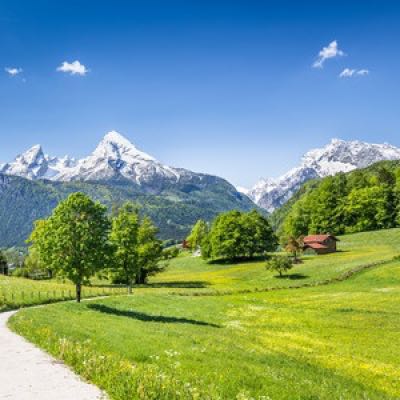
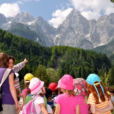
Wandelen in Europa gaat over landen van het Europese continent. Geen land waar geen Wandelkaarten over te vinden zijn. Voor Europa biedt Wandelgidsen van zo’n 35 grote uitgevers. Van de Franse Regio's in het westen tot het uiterste van Finland, tot de prachtige Duitse regio's en terug, alsook het gekende Duitse, Nederlandse en Spaanse landschap; Bibliotrek heeft wat u zoekt.
Als voormalige wandelorganisatie met 25 jaar ervaring spitsten wij ons vroeger toe op begeleide wandelingen in de Franse & Oostenrijkse Alpen. Dankzij onze jarenlange ervaring kunnen wij u, wat wandelgidsen betreft, alle info geven die u zoekt. Heeft u een vraag? Dan lossen wij die voor u op. Het is niet altijd gemakkelijk om uw weg te vinden doorheen de grote hoeveelheid gidsen en uitgevers. Wenst u een kijkje te nemen in de afdeling van de kaarten in plaats van de gidsen? - Fietskaarten Europa - Fietsgidsen Europa


Wandelgids Albsteig HW1 > Nordrandweg Donauwörth - Rother • 9783763314195
Auteur(s): Renate Florl
Wandelgids Albsteig HW1 > Nordrandweg Donauwörth - Rother Productomschrijving: Zertifiziert als »Qualitätsweg Wanderbares Deutschland« »Wandern auf hohem Niveau«, das bietet der Albsteig in doppelter Hinsicht: Mit herrlichen Panoramablicken zieht er entlang des Albtraufs über die höchsten Gipfel der Schwäbischen Alb, der »Region der 10 Tausender«. Und hohes Qualitätsniveau bestätigen d…
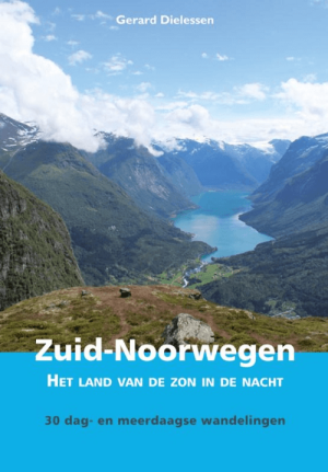
Wandelgids Noorwegen Zuid - Elmar • 9789054725138
Auteur(s): Gerard Dielessen
Wandelgids Noorwegen Zuid - Elmar Productomschrijving: Noorwegen is het land van de zon in de nacht. 's Zomers wil het maar nauwelijks donker worden in het langgerekte Scandinavische land. De dagen zijn dan heerlijk lang. Dat betekent extra genieten van de bergnatuur, die van een bijzondere schoonheid is. Overweldigend ook vaak. In het westen zijn er de fjorden met zijn scherpe pieken en g…

Wandelgids Het hele jaar door op stap - Anwb • 9789018054779
Wandelgids Het hele jaar door op stap doorheen Nederland - Anwb Productomschrijving: 35 wandelingen voor het hele gezin door heel Nederland en in alle seizoenen. Kant en klare ideeën voor een dagje actief zijn in de natuur. Met praktische informatie (zoals de lengte en duur van de wandelingen). Inclusief leuke adresjes om na afloop wat te eten en drinken. Heb je zin om samen met je gez…

Wandelgids Dolomiten Teil 5 - Sextner Dolomiten - Rother • 9783763314300
Auteur(s): Franz Hauleitner
Wandelgids Dolomiten, Sextner Dolomiten - Rother Duitstalige productomschrijving: Wuchtig ragen in den Dolomiten die Felskolosse der berühmten »Drei Zinnen« auf, markant prägen sie die landschaftliche Schönheit des Sexten- und des Pragser Tals. Die felsigen Gipfel, Schluchten, malerischen Täler und Bergseen in dieser Alpenregion sind herrliche Ziele für Wanderungen und Bergtouren. Der Roth…

Wandelgids Cheddar & the Mendips - 15 short walks - Cicerone • 9781786312549
Auteur(s): Rachel Mead
Wandelgids 15 short walks Cheddar & the Mendips - Cicerone Productomschrijving: Would you like to explore the best of Cheddar and the Mendips? This guidebook covers 15 of the best short walks in the area (between 3 and 10km, all under three hours), including Crook Peak and King's Wood, Beacon Batch and Velvet Bottom, Ebbor Gorge and Ebbor Wood, Cheddar Gorge North and Piney Sleights and th…
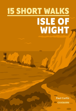
Wandelgids Isle of Wight, 15 short walks - Cicerone Press • 9781786312556
Auteur(s): Paul Curtis
Wandelgids Isle of Wight, 15 short walks - Cicerone Productomschrijving: Would you like to explore the best of the Isle of Wight? This guidebook covers 15 of the best short walks in the area (all under three hours), including The Needles, Carisbrooke Castle, Quarr Abbey and the Tennyson Trail. Why choose this guidebook? - Easy to moderate walks suitable for almost everyone - Shor…
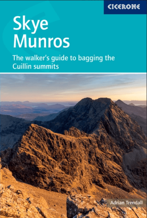
Wandelgids Skye Munros walking - Cicerone Press • 9781786312044
Auteur(s): Adrian Trendall
Wandelgids Isle of Skye Munros walking - Cicerone Pres Productomschrijving: A definitive 2-volume guidebook to the 12 Munros of the Cuillin on the Isle of Skye – the most technically demanding Munros in Scotland, rising in a jagged 3000ft skyline straight from the sea. More than simple hillwalking, these summits demand Grade 3 scrambling, rock climbing to Moderate and abseiling, technical …

Wandelgids Harz 60T - Rother Bergverlag • 9783763314584
Auteur(s): Mark Zahel
Wandelgids Harz - Rother Duitse omschrijving: Der Brocken ist das Paradeziel im Harz. Weithin sichtbar ist seine unverwechselbare Kuppe, die klar aus dem höchsten Mittelgebirge Norddeutschlands heraussticht. Der Harz ist ein perfektes Wandergebiet: Weite Teile sind Nationalpark, durch den herrliche Wege und Pfade führen. Mit einer reichhaltigen Auswahl von 60 Touren wird das gesamte – ehed…
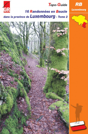
16 randonnées en boucle dans la province de Luxembourg Tome 2 • 9782931078457
16 randonnées dans la province de Luxembourg Productomschrijving: Randonnées en Boucle dans la province de Luxembourg – (Tome 2) Les « Randonnées en Boucle » (RB) offrent aux randonneurs de circuits à la journée, articulés sur les célèbres sentiers de Grande Randonnée, balisés blanc et rouge, les GR. Chacune des provinces wallonnes ainsi que Bruxelles est pourvue d’un topoguide proposa…

Wandelgids Peak Bagging in Peak District NP - Vertebrate Publ. • 9781839812675
Auteur(s): Anna Paxton
Peak Bagging in Peak District NP - Vertebrate Productomschrijving: This number includes 32 routes designed to complete the best 121 Peak District peaks and Ethels (like the Scotisch Munro's) in the most efficient way. In Peak Bagging Peak District, local author Anna Paxton guides you to 121 of the most rewarding summits in the national park, including the 74 accessible Ethels plus 47 other…

Wandelgids Madeira 70 Touren - Rother Bergverlag • 9783763314515
Auteur(s): Rolf Goetz
Wandelgids Madeira 70 Touren - Rother Duitse productomschrijving: Strelitzien, Fackellilien, Liebesblumen und Hortensien – Madeira zeichnet sich durch ein ganzjährig mildes Klima und eine verschwenderische Blütenpracht aus. Die atlantische Schönheit ist ein Paradies für Wanderer. 70 abwechslungsreiche Levada- und Bergwanderungen stellt der Rother Wanderführer »Madeira« vor. Schmale Bew…

Wandelgids Gran Canaria - Rother Bergverlag • 9783763314768
Auteur(s): Izabella Gawin
Wandelgids Gran Canaria - Rother Duitse productomschrijving: Gran Canaria, 85 Touren von Rother Gran Canaria ist weit mehr als Sonne, Strand und Meer: Die drittgrößte Kanareninsel gilt als echtes Paradies für Wandernde. Ihre landschaftliche Vielfalt ist spektakulär – wie ein ganzer Kontinent im Kleinformat. Goldene Dünenfelder, grüne Palmenoasen, tiefe Schluchten und subtropische Täler…

Wandelgids 0100 Les chemins de la guerre de Cent Ans GR100 - FFR • 9782751413568
Les chemins de la guerre de Cent Ans GR100 - FFR Productomschrijving: Plus de 20 jours pour découvrir le GR®100 "Les chemins de la Guerre de Cent Ans" : un itinéraire qui relie les différentes étapes et lieux des affrontements du conflit franco-anglais du 14e siècle. Au départ de Montluçon, ce parcours rejoint Poitiers en passant par une trentaine de sites historiques remarquables (châ…
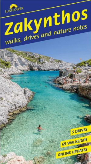
Wandelgids Zakynthos Griekenland - Sunflower Books • 9781856915762
Wandelgids Zakynthos - Sunflower Books Productomschrijving: This guidebook is an ideal companion for motorists who want to tour Zakynthos by car, as well as those planning a holiday walking in Zakynthos. The book combines the best features of our ‘Landscapes’ walking and car touring guides with all the detail you would expect in a hefty general guide, but it is pocket size and in full colo…
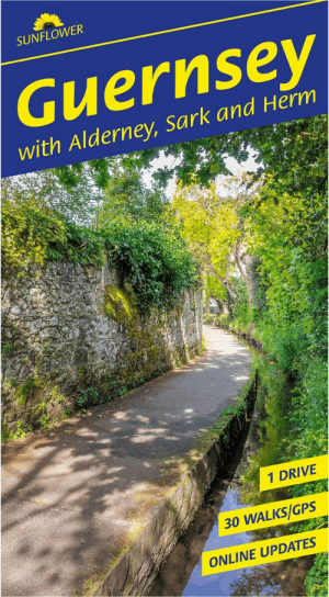
Wandelgids Guernsey with Alderney Sark & Herm - Sunflower books • 9781856915755
Guernsey with Alderney Sark & Herm - Sunflower books Productomschrijving: All the walks have been rechecked for this Sixth edition of Sunflower’s guide to Guernsey, Alderney and Sark. The maps have all been redrawn using Openstreet mapping with reference to GPS tracking, and free downloadable GPS tracks are now available for all the walks in the guide. An ideal introduction for the fir…

Wandelgids Reisgids Madeira Portugal - Sunflower Books • 9781856915786
Auteur(s): John Underwood
Wandelgids Madeira Portugal - Sunflower Productomschrijving: Revised on the island just a couple of months before publication, this new 15th edition of Sunflower’s best-selling guide is in our new wider format, so that no mapping disappears in the middle of two pages. The type is larger as well, and the page count has been extended to 200 pages. A new walk replaces a route which has recent…
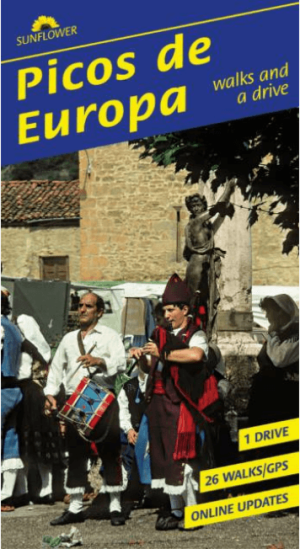
Wandelgids Picos de Europa - Sunflower Books • 9781856915809
Auteur(s): Teresa Farino
Wandelgids Picos de Europa - Sunflower Books Productomschrijving: Every step of every walk has been retraced for this Seventh edition of the best-selling guide to the Picos. The maps have been revised where necessary, and free downloadable GPS tracks are now available for all the walks. The Picos de Europa, one of Europe’s last mountain wilderness areas, are the high point of a long r…
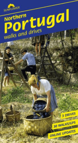
Wandelgids Noord Portugal Northern - Sunflower Books • 9781856915748
Wandelgids Northern Portugal - Sunflower Books Productomschrijving: This book helps you explore northwestern Portugal by car or on foot. Here, in the province of Minho (arguably the most beautiful part of the country), the lush greenness of the coastal lowlands, the Costa Verde, contrasts sharply with the mountainous interior — one of Europe’s last wilderness areas. While emphasising excu…
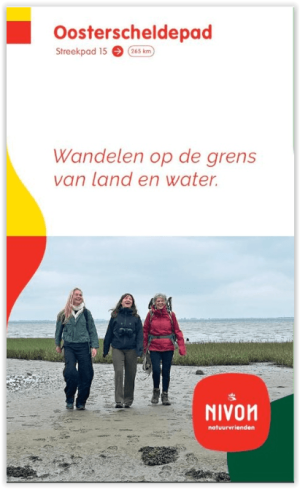
Wandelgids 15 Streekpad Oosterscheldepad 196km - Nivon • 9789491142253
Auteur(s): Nivon Werkgroep Oosterscheldepad
Wandelgids Oosterscheldepad 196km - Nivon Productomschrijving: Het Oosterscheldepad is een afwisselend Streekpad in 16 etappes, dat een kennismaking biedt met het nieuwste Nationaal Park van Nederland. De al eeuwen durende strijd tegen het water is op veel plaatsen langs de route nog goed waarneembaar: van oude inlagen en verdronken polders tot en met de modernste Deltawerken. Onderweg is…
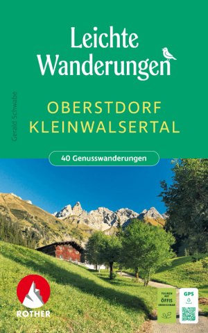
Wandelgids Oberstdorf & Kleinwalsertal - Rother Bergverlag • 9783763334636
Auteur(s): Gerald Schwabe
Wandelgids Oberstdorf & Kleinwalsertal - Rother Duitse Productomschrijving: Genussvolles Wandern im Allgäu – dieses Wanderbuch präsentiert 40 leichte Touren für Bergliebhaber, die es lieber etwas entspannter angehen lassen wollen. Die Genusstouren führen ins südliche Oberallgäu rund um Oberstdorf und ins Kleinwalsertal, in die meist komplett autofreien Täler wie Oytal, Trettachtal oder St…
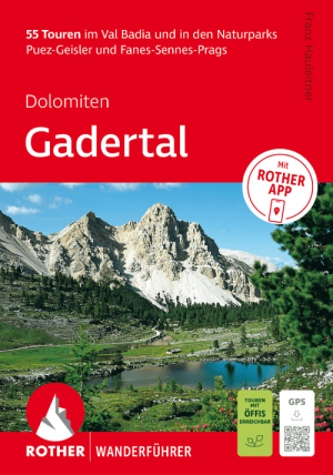
Wandelgids Dolomiten, Gadertal - Bruneck bis Corvara - Rother • 9783763314492
Auteur(s): Franz Hauleitner
Wandelgids Dolomiten, Gadertal - Bruneck bis Corvara - Rother Productomschrijving: 55 Touren im Val Badia und in den Naturparks Puez-Geisler und Fanes-Sennes-Prags. Teil aufragende Felsriesen, kristallklare Bergseen, herrliche Aussichtspunkte und luftige Gipfel – in den Dolomiten entdecken Wanderer eine grandiose Hochgebirgslandschaft. Das Gadertal ist eine der bedeutendsten touristischen …
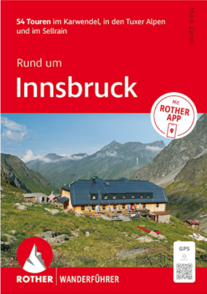
Wanderführer Rund um Innsbruck - Rother Bergverlag • 9783763314928
Auteur(s): Mark Zahel
Wanderführer Rund um Innsbruck - Rother Productomschrijving: 54 Touren im Karwendel, in den Tuxer Alpen und im Sellrain Urbanes Leben und stilles Gebirge ganz nah beieinander – Innsbruck, die heimliche Hauptstadt der Alpen, macht es möglich. Eingerahmt von einer fantastischen Bergwelt lässt die Tiroler Metropole das Herz eines jeden bergbegeisterten Stadtmenschen höher schlagen. Der Ro…
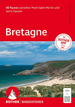
Wanderführer Bretagne 272 - Rother Bergverlag • 9783763314775
Wanderführer Bretagne - Rother Productomschrijving: Bretagne, 50 wandelroutes tussen Mont-St-Michel & St-Nazaire. Die Bretagne, im Nordwesten von Frankreich gelegen, gilt als echtes Paradies zum Wandern. Die Halbinsel am Atlantik fasziniert mit schroffen Steilküsten und einsamen Sandstränden, grünen Weiden und dichten Wäldern, romantischen Flusstälern und malerischen Fachwerkstädtchen.…
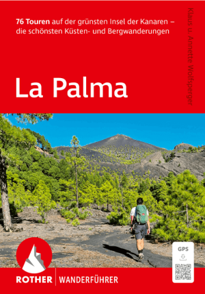
Wandelgids La Palma Wanderführer - Rother Bergverlag • 9783763315291
Auteur(s): Annette Wolfsperger, Klaus Wolfsperger
Wandelgids La Palma Canarische inseln - Rother Duitse Productomschrijving: La Palma, die grünste Insel der Kanaren, wartet mit einer landschaftlichen Vielfalt auf, wie sie kaum eine andere, vergleichbar kleinräumige Region dieser Welt bieten dürfte. Weite Täler, wilde Schluchten und Kraterlandschaften, Kiefern- und Lorbeerwälder, Bananenplantagen, Kaskaden und Wasserfälle kontrastieren mit…
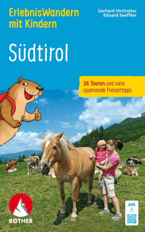
Wandelgids Südtirol, Erlebniswandern mit Kindern - Rother • 9783763334605
Auteur(s): Eduard Soeffker, Gerhard Hirtlreiter
Wandelgids Südtirol, Erlebniswandern mit Kindern - Rother Productomschrijving: Südtirol - Erlebniswandern mit Kindern (wb) - In Südtirol gibt es für Kinder viel zu erleben: Zwischen dem fast viertausend Meter hohen Ortler und den spektakulären Felszinnen der Dolomiten locken wilde Gebirgslandschaften mit Schluchten und Wasserfällen, die nicht nur die Kleinen zum Staunen bringen. Abenteuerp…
Wandelvakantie door Europa
Wandelvakantie door Europa is op zich een sport geworden. Of u nu simpelweg op zondagmiddag een strandwandeling maakt, of u gaat op ware bedevaarttocht langs een 1500 km lange Historische fiets- en wandelroutes, bij Bibliotrek kunnen wij u begeleiden naar de juiste uitgever die de meest relevante gids voor u heeft met de meeste info voor die specifieke route die u wenst af te leggen. De wandelgidsen van Bibliotrek werden allemaal zorgvuldig geselecteerd aan de hand van de kennis en ervaring van de verbonden uitgeversorganisaties. Ook met de Reisgidsen van Europa komt u overal.
De meest bekende zijn de nationale uitgevers zoals bijvoorbeeld NGI(B) voor België en FFRP voor Frankrijk. Daarnaast zijn er nog honderden andere uitgevers en diensten die wandelgidsen uitbrengen. De ene uitgever is echter de andere niet. Er komt heel wat bij kijken om een overzichtelijke wandelgids te ontwikkelen met de nodige informatie en relevante lokalisering. Vaak zijn uitgevers ook niet 100% toegewijd aan enkel wandelen. Ze brengen in sommige gevallen dan een kluwen aan gidsen en kaarten uit die vanalles omvatten, van skiën tot rolschaatsen.
De echte wandelgids uitgevers zijn er echter gemakkelijk uit te halen. De Wandelgidsen die gaan over het Europese continent, en dan meerbepaald het West-Europese continent, zijn een pak gedetailleerder dan bijvoorbeeld de gidsen van de meeste Zuid-Amerikaanse cartografen. In het Westen neemt de wandelaar niet zomaar de eerste de beste gids uit de rekken, maar wordt er tijd gestopt in het kiezen van de beste gids. En daarbij komt Bibliotrek natuurlijk goed van pas.
Europese wandelgidsen
Europese wandelgidsen zijn van onschatbare waarde voor iedereen die de diverse landschappen van het continent te voet wil verkennen. Deze Wandelgidsen bieden gedetailleerde informatie over een breed scala aan paden, van uitdagende bergroutes tot ontspannen wandelingen langs de kust. Of je nu door de ruige Alpen trekt, door de oeroude bossen van de Scandinavië landen dwaalt of de schilderachtige kusten van de Middellandse Zee verkent, een goede wandelgids biedt essentiële inzichten in het terrein, de moeilijkheidsgraden en de belangrijkste bezienswaardigheden onderweg.
De meeste Europese wandelgidsen bevatten ingetekende kaarten, hoogteprofielen en praktische tips over accommodatie, vervoer en weersomstandigheden. Ze benadrukken vaak interessante punten, zoals Historische fiets- en wandelroutes, pittoreske dorpjes en natuurwonderen, waardoor het voor wandelaars gemakkelijker wordt om hun routes te plannen en hun ervaring te maximaliseren. Gidsen geven ook belangrijke informatie over veiligheid, zoals advies over wat je moet meenemen, hoe om te gaan met lokale wilde dieren en de beste tijd van het jaar om specifieke paden te bewandelen.
Voor wie op zoek is naar meerdaagse avonturen, stellen wandelgidsen vaak routes voor, compleet met aanbevelingen voor lokale pensions, berghutten en campings, waar je kunt Kamperen uiteraard. Of je nu een doorgewinterde wandelaar bent of een beginner, deze gidsen helpen je vol vertrouwen over de paden van Europa te navigeren en zorgen voor een veilige en plezierige reis door enkele van de mooiste landschappen van het continent.