

Wandelgids Walking the Munros Vol 1 - Cicerone Press
69 challenging routes across Glencoe- Bridge of Orchy and Mull


Korte omschrijving
Wandelgidsen Highlands, Schotland van CICERONE Press. Ideaal voor tochten in Schotland.
Walking the Munros Vol 1 - Cicerone Productomschrijving: Wandelgids over de Munros in de zuidelijke, centrale en westelijke Highland's. De gids beschrijft 69 uitdagende routes over 139 van d...

Specificaties
- Uitgever: CICERONE Press
- ISBN-13: 9781786311054
- HOOFDCATEGORIEËN: Wandelgids
- Activiteiten: Wandelen, Hiking & Trekking
- Auteur: Steve Kew
- Regio: Highlands, Schotland
- Land: Schotland
- Editie: 4
- Taal: Engels
Volledige omschrijving
Walking the Munros Vol 1 - Cicerone
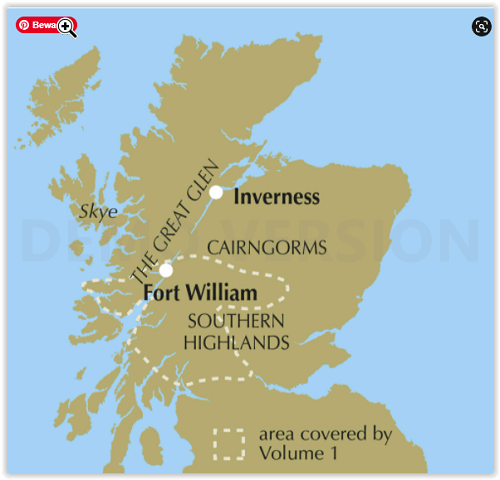
Productomschrijving: Wandelgids over de Munros in de zuidelijke, centrale en westelijke Highland's. De gids beschrijft 69 uitdagende routes over 139 van de meest iconische 3000f+ bergen in gebieden zoals Glencoe, Bridge of Orchy en Mull. Inclusief routes op Ben More, Ben Alder, Ben Lomond en Ben Nevis, de hoogste berg van de Britse eilanden. Deel 1 van twee reisgidsen.
Engelse omschrijving: Guidebook to walking the Munros in southern, central and western Highlands. Describes 69 challenging routes across 139 of the iconic 3000ft+ mountains covering areas such as Glencoe, Bridge of Orchy and Mull. Includes routes up Ben More, Ben Alder, Ben Lomond and Ben Nevis, the highest mountain in the British Isles. Volume 1 of two guidebooks.
Seasons:
Year-round mountain walking, with summer walking in mind. However, midges may hold you back in summer, and if snow's not your thing then avoid winter.
Centres:
Fort William, Glencoe, Killin, Pitlochry, Blair Atholl, Oban and many more.
Difficulty:
Many Munros are straightforward walks, but some have exciting ridge walking and scrambling. Aonach Eagach is covered in this volume. Normal Scottish mountain challenges and precautions.
Must See:
The extroardinary beauty of Scotland's mountain landscape; the challenge of a long and strenuous climb; the achievement of the summit; the sight of wilderness stretching out for miles around; the tidal wave of cloud flowing over a ridge; the sweet peace of that first refreshment at the end of the day.
Locatie op kaart
Artikelen uit dezelfde regio
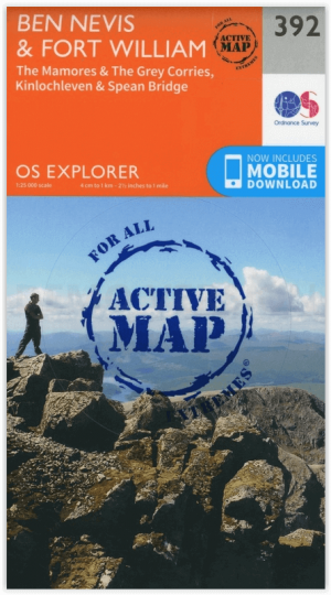
Wandelkaart 392 Ben Nevis- Highland's Schotland - OSI • 9780319472552
Wandelkaart Ben Nevis- Highland's Schotland - OSI The Mamores & The Grey Corries Kinlochleven & Spean Bridge. Productbeschrijving: Kaart nummer 392 in de OS Explorer kaart reeks is de perfecte kaart om te gebruiken bij het verkennen van het bergachtige gebied van Ben Nevis, bij Fort William, The Mamores en The Grey Corries Kinlochleven Spean Bridge. Het gebied word bezocht door bergbek…
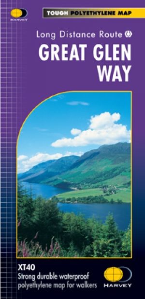
Wandelkaart Great Glen Way - Schotland - Harvey maps • 9781851374632
Wandelkaart Great Glen Way - Schotland - Harvey maps Productomschrijving: Toont de gehele route op één vel. 117km (73 mijl) van Fort William tot Inverness via Fort Augustus langs het Caledonisch Kanaal en de noordelijke oever van Loch Ness. Informatie over het vinden van accommodatie, camping, voedsel. Routebeschrijving naar het start van de route. Nieuwe generatie HARVEY Superwalker,…
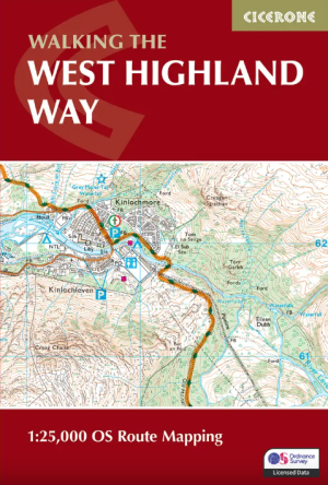
Wandelgids West Highland Way Map Booklet - Cicerone • 9781786311788
The West Highland Way Map Booklet - Cicerone Productomschrijving: Dit compacte kaartboekje toont de volledige route van de 152,88 km lange Schotse langeafstandsroute West Highland Way, via Loch Lomond en Rannoch Moor. Dit boekje is inbegrepen bij de Cicerone gids voor de route en toont de volledige route op Ordnance Survey 1:25.000 kaarten. Engelse omschrijving: This compact boo…

Wandelgids Great Glen Way - Rucksack Readers • 9781898481874
Wandelgids - Great Glen Way - Rucksack Readers Productomschirjving: De Great Glen Way loopt 124 km lang langs de Great Glen van Schotland tussen Fort William en Inverness. Het volgt het historische Caledonische kanaal en loopt langs vier van de mooiste meren van de Hooglanden, waaronder Loch Ness, beroemd om zijn monsterlegende en om Urquhart Castle. SecLons van de High Route bieden een pr…

Wandelkaart 442 Assynt & Lochinver- Schotland - OSI • 9780319472941
Wandelkaart Assynt & Lochinver - Highland's Schotland Omvat ook: Kylesku & Inchnadamph. Productbeschrijving: Van Kylesku tot Lochinver en The Minch, het hele gebied werd aangewezen als een National Scenic Area. Er zijn 2 Munro's is dit gebied - Ben More Assynt staat met zijn 998m op kop. De OS Explorer kaart voor Assynt & Lochinver is beschikbaar in zowel als de standaard papieren vers…