
Wandelgids Walker's Haute Route Chamonix to Zermatt - Knife Edge
An incredible trek between Chamonix France & Zermatt Switzerland
Korte omschrijving
Wandelgidsen Wallis, Zwitserland, Auvergne-Rhône-Alpes, Frankrijk en Rhône-Alpes, Frankrijk van Knife Edge Outdoor Limited. Ideaal voor tochten in Frankrijk en Zwitserland.
Walker's Haute Route Chamonix to Zermatt - Knife Edge Productomschrijving: Complete guidebook for planning and trekking the Walker's Haute Route Start at Mont Blanc and finish at the Mat...

Specificaties
- Uitgever: Knife Edge Outdoor Limited
- ISBN-13: 9781912933624
- HOOFDCATEGORIEËN: Wandelgids
- Activiteiten: Wandelen, Hiking & Trekking
- Regio: Auvergne-Rhône-Alpes, Frankrijk, Rhône-Alpes, Frankrijk, Wallis, Zwitserland
- Land: Frankrijk, Zwitserland
- Departement: Haute-Savoie (74), Isère (38)
- Lange afstand wandelroutes: Chamonix top Zermatt - (144km) Haut route
- Editie: 2
- Taal: Engels

Volledige omschrijving
Walker's Haute Route Chamonix to Zermatt - Knife Edge
Productomschrijving: Complete guidebook for planning and trekking the Walker's Haute Route
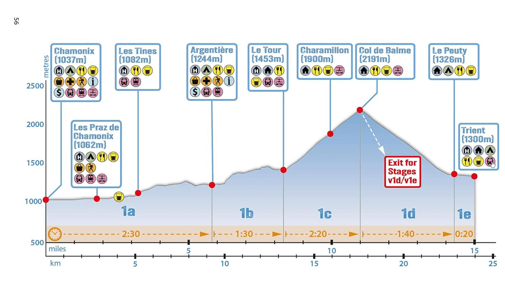
Start at Mont Blanc and finish at the Matterhorn. On the way, pass the largest collection of snowy 4000m summits in the Alps. An incredible trek between Chamonix, France and Zermatt, Switzerland, the two most famous mountain towns in the Alps. This trek should be on your hiking bucket list. Oild mountain terrain: amazing glaciers, jagged peaks, beautiful valleys and pastures, shimmering lakes, carpets of wild flowers and the soothing sound of cow bells.
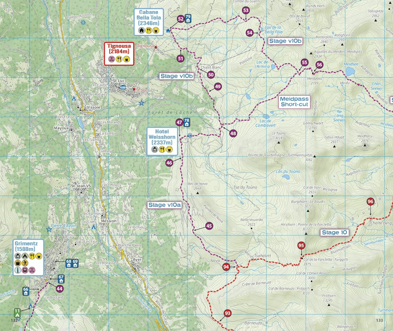
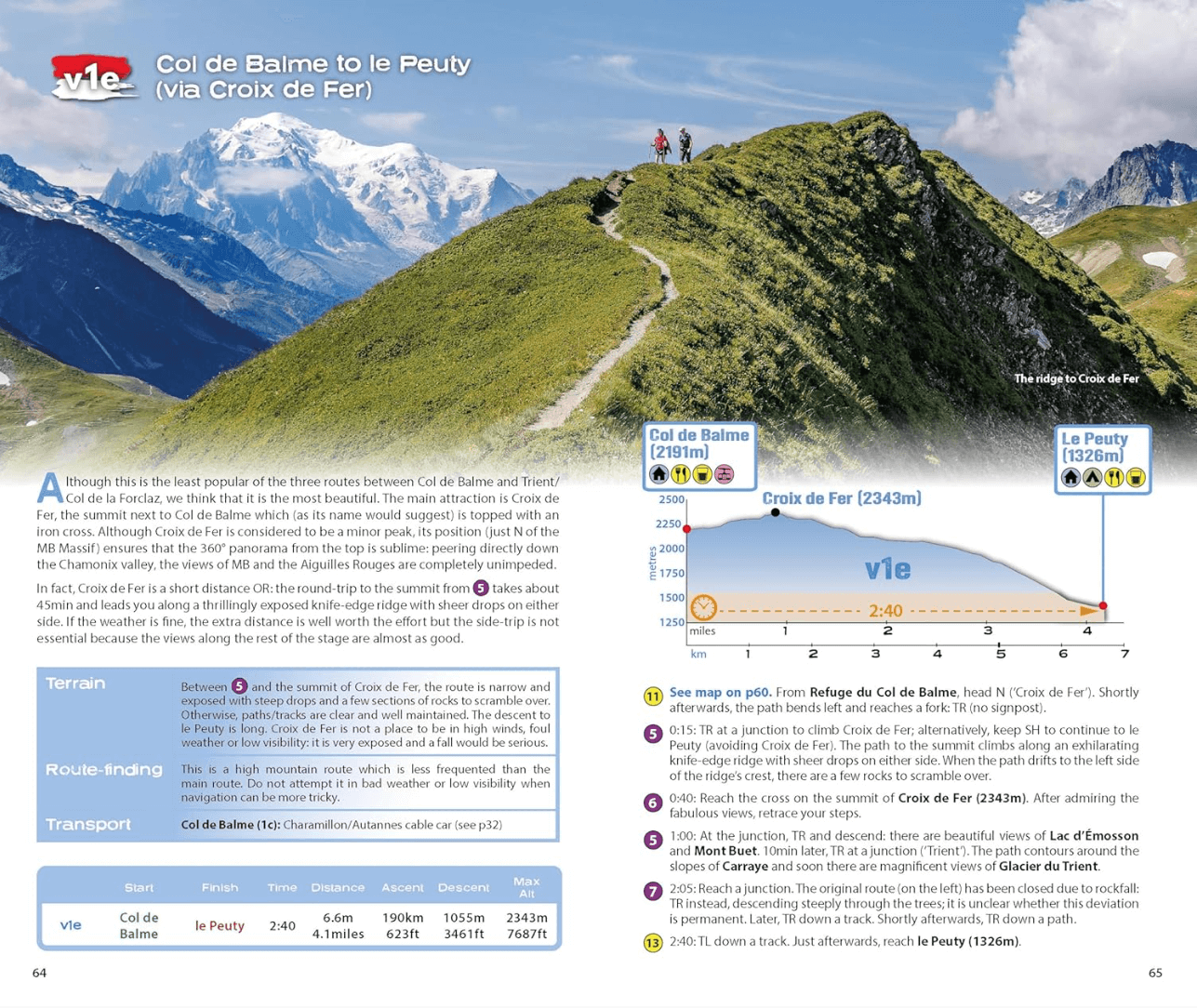
- Real maps rather than basic sketch maps
- Unique itinery planner
- Everything the trekker needs to know
- Full accomodation listings
- Complete list of camping locations
- Section on Zermatt day walks
- 13 exciting route variants
- Information for both self-guided and guided trekkers
Artikelen uit dezelfde regio
Landkaart Wegenkaart Limousin & Auvergne (Franstalig)- ExpressMap • 9788380462410
Wegenkaart Limousin & Auvergne (Franstalig) - Expressmap Productomschrijving: ExpressMap is de uitgever van comfort! maps, geplastificeerde kaarten die eenvoudig te vouwen zijn, zelfs met één hand. Een uniek en innovatief product. Comfortabel, waterbestand, onverscheurbaar, comfort! maps blijven hun kwaliteit lang behouden. Duurzame kaarten, nuttig om een uitstap te plannen en handig voor …

Wandelkaart 2431 SB Pontaumur France - IGN • 9782758539575
Wandelkaart - Pontaumur France Productomschrijving: Pontaumur is een gemeente in het Franse departement Puy-de-Dôme in de regio Auvergne-Rhône-Alpes. De plaats maakt deel uit van het arrondissement Riom. Desciptive produits: Une nouvelle cartographie pour une lisibilité optimale, avec une meilleure précision géométrique et des informations touristiques enrichies. Un nouveau format deux…

Wandelkaart 2834 SB Monistrol-sur-Loire & Retournac - IGN • 9782758548928
Wandelkaart - Monistrol-sur-Loire & Retournac Productomschrijving: Monistrol-sur-Loire & Retournac zijn gemeentes in het Franse departement Haute-Loire in de regio Auvergne-Rhône-Alpes. De plaats maakt deel uit van het arrondissement Yssingeaux. Tussen 2014 en 2020 vernieuwt IGN haar volledige collectie serie blauw. Een nieuwe toewijzing voor optimale leesbaarheid, met een grotere mate…

Wandelkaart 3132 SB Bourgoin-Jallieu & La Verpillère - IGN • 9782758535713
Wandelkaart 3132 SB - Bourgoin-Jallieu & La Verpillère Omvat: Bourgoin-Jallieu is een gemeente in het Franse departement Isère (regio Rhône-Alpes) De plaats maakt deel uit van het arrondissement La Tour-du-Pin. Productomschrijving: Tussen 2014 en 2018 vernieuwt IGN haar volledige collectie serie blauw. Een nieuwe toewijzing voor optimale leesbaarheid, met een grotere mate van geometris…
Wandelkaart 3335 ET(R) Le Bourg d'Oisans & L'Alpe d'Huez - IGN • 9782758551614
Le Bourg d'Oisans- L'Alpe d'Huez et Les Grandes Rousses Productomschrijving: Le Bourg d'Oisans is een gezapig gezellig dorp op 60km van Grenoble in de Franse Alpen. Het dorp ligt aan de voet van de 21 bochten tot boven in Alpe d'Huez, een skistad zeg maar, die uitklijkt op de flanken van het nationaal park Ecrin. Bourg d'Oisans is tegelijk ook het startpunt van de befaamde GR54 wandelroute…