

Wandelgids trekking in Austria's Hohe Tauern - Cicerone
De Reichen- Venediger- & Gross Glockner-groepen


Korte omschrijving
Wandelgidsen Karinthië, Oostenrijk, Tirol, Oostenrijk en Salzburg, Oostenrijk van CICERONE Press. Ideaal voor tochten in Oostenrijk.
Trekking in Austria's Hohe Tauern - Cicerone Press Productomschrijving: Het Nationaal Park Hohe Tauern ligt in het hart van Oostenrijk en de oostelijke Alpen en heeft de internationale statu...

Specificaties
- Uitgever: CICERONE Press
- ISBN-13: 9781786310644
- HOOFDCATEGORIEËN: Wandelgids
- Activiteiten: Wandelen, Hiking & Trekking
- Auteur: Allan Hartley
- Regio: Karinthië, Oostenrijk, Salzburg, Oostenrijk, Tirol, Oostenrijk
- Land: Oostenrijk
- Toepasselijke bergketen: Höge Taurn, Karinthië Oostenrijk
- Nationale parken: Hohe Taurn NP, Oostenrijk
- Editie: 2
- Taal: Engels
- Iconische Bergketens van Europa: Hohe Tauern, Oostenrijk
Volledige omschrijving
Trekking in Austria's Hohe Tauern - Cicerone Press
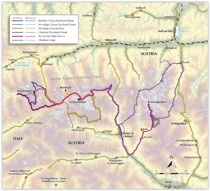
Productomschrijving: Het Nationaal Park Hohe Tauern ligt in het hart van Oostenrijk en de oostelijke Alpen en heeft de internationale status van werelderfgoed. De adembenemende valleien worden aangevoerd door tientallen bergtoppen die enkele van de beste hutten in de Alpen herbergen. Deze gids concentreert zich op drie gebieden, De Reichen-, Venediger- en Gross Glockner-groepen. In elk deel worden verschillende tochten van hut naar hut beschreven, samen met excursies en aanbevolen beklimmingen.
Omvat: Gross Glockner, Austria's highest peak, Gross Venediger, Rosskar Scharte, the Loebbentorl pass, the Obersulzbachkees glacier, Stocker Scharte, the walk around the head of the Virgental valley, Spitzbrett ridge, Kalser Tauern pass, the welcoming huts of the Austrian Alpine Club.
Engelse omschrijving: Situated in the heartland of Austria and the Eastern Alps the Hohe Tauern National Park has international status as a World Heritage Site. Its stunning valleys are headed by scores of peaks that are home to some of the best huts in the Alps. This guidebook concentrates on three areas – the Reichen, Venediger and Gross Glockner Groups. In each section, descriptions are provided for various hut-to-hut tours along with excursions and recommended climbs.
This guidebook describes five routes in the Reichen Group, the Venediger Group and the Gross Glockner, any of which would make an ideal introduction to the delights of Alpine trekking. There are 4 multi-day treks described and a 10-day traverse of the whole region from Mayrhofen, through the Reichen Group and across the Venediger to end with a climb on the Gross Glockner is outlined.
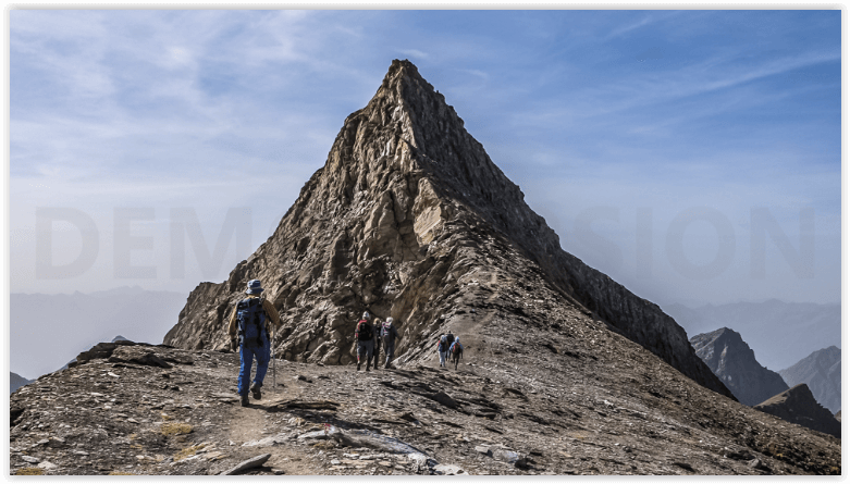
Routes described in this guidebook, such as on the Reichen Group Runde Tour and the Venediger Hohenweg, vary from traditional mountain paths to tracks across boulder fields and rough ground. There is also steep ground, late summer snow and fixed wire ropes here and there to aid stability.
The Hohe Tauern provides opportunities for all mountain enthusiasts, whatever their aspirations. It is ideal for the first time visitors to the Alps, particularly family groups with adventurous children, but it is even more so for aspiring alpinists, who would be wrong to see the Hohe Tauern as tame. These mountains can challenge even the most experienced alpinist, you will not be disappointed.
The tours are moderately strenuous and require the ability to carry a full pack for an average of six hours a day. In terms of alpine grading, the majority of the routes fall into the mountaineering grade of easy to moderate, comprising of sustained mountain walking, requiring the ability to negotiate steep ground, scramble over rocks, cross late summer snow, make use of fixed wire ropes and have a good head for heights.
Seasons:
The summer Alpine season starts when the huts open in mid-June and continues through to the end of September. Early season, snow can linger well into July. July through to August the weather is more settled and warmer, whereas September is cooler.
Centres:
The Hohe Tauern is easily accessed from Munich, Innsbruck and Salzburg, with regular local transport links to various trek starting points such as Matrei in Ost Tirol and Kals am Glockner.
Difficulty:
All tracks and trails are waymarked and frequently signposted. No special equipment is needed, nor additional climbing skills required unless you plan to cross glaciers or undertake the optional ascents of neighbouring peaks.
.png)
Artikelen uit dezelfde regio

Wandelkaart 3 Allgäuer Alpen & Kleinwalsertal - Kompass • 9783991219521
Wandelkaart Allgäuer Alpen & Kleinwalsertal - Kompass Productomschrijving: Deze gloednieuwe wandelkaart van Kompass omvat een bergmassief van de Noordelijke Kalkalpen. Gelegen in de regio's Tirol en Vorarlberg in Oostenrijk is dit één van de spectaculaire gebieden van Oostenrijk. De 5in1-wandelkaart is nu nog duidelijker en gemakkelijker te lezen. De wandelkaart is uitgerust met een ex…

Wandelkaart 009 Alpi Carniche & Karnische Alpen - Tabacco Ed. • 9788883152115
Wandelkaart Alpi Carniche & Karnische Alpen - Tabacco Ed. Productomschrijving: Alpi Carniche / Karnische Alpen / Carnia Centrale tab met schaal 1:25 000 Voor een ontspannende wandeling of een uitdagende beklimming. Om het prachtige landschap te verkennen of voor het plannen van wandel-, mountainbike en skireizen. Voor iedereen, op elk moment van het jaar, in de hele oostelijke Alpen. E…
Wandelkaart & Fietskaart Venedigergruppe - Publipress • 9783961325108
Wandelkaart & Fietskaart - Venedigergruppe Productomschrijving: Aan de voet van de 'wereldse majesteit', de Glacier Großvenediger, wacht een van de grootste beschermde gebieden van de Alpen, metb de ontdekking van het nationale park Hohe Tauern. Van de adembenemende Krimmler watervallen naar het pittoreske Gastein-dal met zijn geneeskrachtige bronnen, word in het vakantiegebied van het Nat…
Wandelgids Osttirol - Zwischen Hohen Tauern & Karnischen Alpen • 9783763333875
Wandelgids Osttirol - Hohen Tauern & Karnischen Alpen - Rother Productomschrijving: Deze omgeving meet ongeveer 2000 vierkante kilometer - niet echt een enorm gebied in de brede Alpenboog. Maar wat het aan landschap te bieden heeft is enorm. Van de gletsjers op de hoofdkam van de Alpen tot de kalksteentorens boven het dalbekken van Lienz zijn er grote contrasten te vinden: dalen die vol ch…

Wandelkaart 40 - Bad Gastein - Kompass • 9783991215523
Wandelkaart Bad Gastein- Bad Hofgastein & Dorfgastein - Kompass Productomschrijving: Bad Gastein, Bad Hofgastein & Dorfgastein zijn vakantiebestemming en kuurplaatsen in Oostenrijk, in het Gasteinertal, in het Salzburgerland. Het stadje ontleent zijn betekenis aan de radon bevattende bronnen die er voorkomen. De 4in1-wandelkaart is nu nog duidelijker en gemakkelijker te lezen. De wande…