

Wandelgids Shropshire Way walking - Cicerone
De Shropshire Way is een dikke 290 km lang

Korte omschrijving
Wandelgidsen West Midlands van CICERONE Press. Ideaal voor tochten in England.
Wandelgids - Shropshire Way walking - Cicerone Productomschirjving: De Shropshire Way is een dikke 290 km lang, en start in Shrewsbury, loopt van Clun, Ludlow, Ironbridge, Wem & Whitchurch....

Specificaties
- Uitgever: CICERONE Press
- ISBN-13: 9781786310088
- HOOFDCATEGORIEËN: Wandelgids
- Activiteiten: Wandelen, Hiking & Trekking
- Auteur: John Gillham
- Regio: West Midlands
- Land: England
- Lange afstand wandelroutes: Shropshire Way (circular walks) (321 km)
- Editie: 1
- Taal: Engels
- De Engelse Graafschappen: Shropshire
Volledige omschrijving
Wandelgids - Shropshire Way walking - Cicerone
Productomschirjving: De Shropshire Way is een dikke 290 km lang, en start in Shrewsbury, loopt van Clun, Ludlow, Ironbridge, Wem & Whitchurch. Een regio met een subliem regionaal landschap. De gids omvat 2 grote cirkelvormige en één kleine wandelroutes.
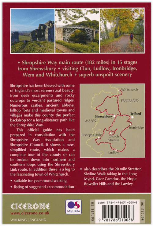
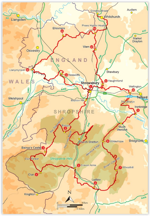
Product description: Guidebook describing a 2 week trail around Shropshire. The 182 mile (290km) route is made up of two loops centred on Shrewsbury and visits Stiperstones, Wenlock Edge, Ironbridge and the Wrekin. Also describes the challenging 20 mile (32km) Stretton Skyline Walk.
SeasonsThe walk can be done in all seasons, but spring, summer and autumn are best as woodland paths can be slippery in winter. Regardless of the season, waterproofs are essential Centres Shrewsbury, Bishop's Castle, Clun, Craven Arms, Ludlow, Much Wenlock, Ironbridge, Wellington, Wem, Whitchurch, Ellesmere, Llanymynech, Nesscliffe Difficulty
The well-marked Way is 182-200 miles, depending on the route chosen, and requires moderate fitness and a good pair of walking boots to cover approximately 12 miles each day. The hills are generally gentle and rolling, although Stiperstones has a rough quartzite ridge Must See
Shrewsbury's ancient architecture; the Stiperstones; Offa's Dyke; Clun Castle; historic Ludlow; Brown Clee Hill (Shropshire's highest); Wenlock Edge; Ironbridge, birthplace of the Industrial Revolution; the Shropshire Union Canal; Haughmond Abbey; Grinshill sandstone quarry.

Locatie op kaart
Artikelen uit dezelfde regio

Wandelkaart 219 Wolverhampton- Dudley & Stourbridge - OSI • 9780319470916
Wandelkaart Wolverhampton- Dudley & Stourbridge - England Omvat ook: Stourbridge & Kidderminster. Productbeschrijving: Kaart nummer 219 dekt Kidderminster, Wolverhampton, Dudley en Stourbridge. Hoogtepunten zijn de Forest van Mercia en de rivier Stour. Omvat ook Halesowen, Bromsgrove, Brierley Hill, Wednesbury en Bloxwich. De OS Explorer kaart voor Wolverhampton & Dudley is beschikbaar…

Wandelkaart 258 Stoke-on-Trent & Newcastle-under-Lyme- OSI • 9780319471302
Wandelkaart Stoke-on-Trent & Newcastle-under-Lyme - England Omvat ook: Biddulph & Stone. Productbeschrijving: Van Biddulph in het noorden tot Stone in het zuiden tot de bestrating van Stoke-on-Trent en Newcastle-under-Lyme, zal OS Explorer kaart blad 258 zal u helpen bij het verkennen van deze industriële landschappen. De OS Explorer kaart voor Stoke-on-Trent & Newcastle-under-Lyme is …

Wandelkaart 220 Birmingham Walsall & Solihull - OSI • 9780319470923
Wandelkaart Birmingham- Walsall- Solihull & Redditch - England Omvat ook: Walsall, Solihull & Redditch. Productbeschrijving: Kaart nummer 220 in de OS Explorer reeks beslaat het gebied in de Midlands rond Birmingham en Solihull. Hij omvat de omgeving van Walsall en het bos van Mercia in het noorden van de kaart, naar Redditch in het zuiden. Hier lopen de paden van de Beacon Way, de Gra…

Wandelkaart XT Malvern Hills AONB England - Harvey map • 9781851376056
Wandelkaart - Malvern Hills AONB England - Harvey map Productomschrijving: Deze Mavern Hills zijn een samenstelling van heuvels in de Engelse counties, Worcestershire, Herefordshire, en een klein deel van Gloucestershire, en domineren de volledige regio rond deze counties van het district van Alvern Hills. Het hoogst gelegen punt van deze regio biedt een panorama van de Severn vallei met d…

Wandelkaart 220 Birmingham- West Midlands - OSI • 9780319244135
Wandelkaart Birmingham- West Midlands - England Productbeschrijving: Walsall, Solihull & Redditch 220 / Birmingham, West Midlands, England - Kaart nummer 220 in de OS Explorer reeks beslaat het gebied in de Midlands rond Birmingham en Solihull. Bekleed van Walsall en het bos van Mercia in het noorden van de kaart naar Redditch in het zuiden, langsde paden van de Beacon Way, en de Gra…