

Wandelgids Kintyre Way Schotland - Rucksack Readers
Begint bij Tarbert via Campbeltown en Southend naar Machrihanish
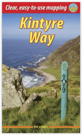
Korte omschrijving
Wandelgidsen Argyll & Bute, Schotland van RUCKSACK READERS. Ideaal voor tochten in Schotland.
The Kintyre Way, Argyle & Bute Schotland - Rucksack Readers Productomschrijving: De Kintyre Way is een volledig bewegwijzerde route die het schiereiland Kintyre over een afstand van 101 mijl...


Specificaties
- Uitgever: RUCKSACK READERS
- ISBN-13: 9781913817121
- HOOFDCATEGORIEËN: Wandelgids
- Activiteiten: Wandelen, Hiking & Trekking
- Auteur: Sandra Bardwell
- Regio: Argyll & Bute, Schotland
- Land: Schotland
- Lange afstand wandelroutes: Kintyre Way, Argyl & Bute Schotland (150 km)
- Schaal: 1:65000
- Editie: 4
- Taal: Engels
Volledige omschrijving
The Kintyre Way, Argyle & Bute Schotland - Rucksack Readers
Productomschrijving: De Kintyre Way is een volledig bewegwijzerde route die het schiereiland Kintyre over een afstand van 101 mijl (162 km) doorkruist. De route begint bij Tarbert in het noorden en voert langs kustdorpen en meren in het binnenland, via Campbeltown en Southend naar het nieuwe eindpunt Machrihanish. Onze editie voor 2023 bevat wijzigingen in zowel de route als de faciliteiten, en heeft zes extra pagina's. Het boek bevat grootschalige kaarten van Footprint en veel nieuwe foto's. Onze online routekaart is de meest nauwkeurige bron die beschikbaar is: zoom herhaaldelijk in voor ongelooflijke details.
Kintyre is beroemd als het enige 'vastelandseiland' van Schotland en heeft ruige kustlijnen die uitkijken op het westen naar de Atlantische Oceaan en op het oosten naar de Firth of Clyde. U wandelt langs kastelen, abdijen en prehistorische overblijfselen, langs stranden, over heidevelden en klimt hoog over bospaden met prachtige uitzichten over Arran en richting Ierland. Op dit vredige schiereiland zult u veel wilde dieren zien.
Engelse omschrijving: The Kintyre Way is a fully waymarked trail that criss-crosses the Kintyre peninsula for 101 miles (162 km). Starting from Tarbert in the north, it visits coastal villages and inland lochs, passing through Campbeltown via Southend to its new terminus of Machrihanish. Our 2023 edition covers changes in both route and facilities, and has six extra pages. The book includes large-scale mapping by Footprint, and has many new photos. Our online route map is the most accurate resource available: zoom repeatedly for incredible detail.
Famous as Scotland’s only ‘mainland island’, Kintyre has rugged coastlines facing west to the Atlantic and east to the Firth of Clyde. You walk past castles, abbeys and prehistoric remains, along beaches, over moorland and climb high on forestry tracks with glorious views over Arran and towards Ireland. You will enjoy many wildlife sightings on this peaceful peninsula.
This guidebook contains all you need to plan and enjoy the Kintyre Way:
- detailed description of the route from north to south
- summaries of each section, with distance, terrain and refreshment stops
- fully updated for 2023
- habitats and wildlife
- whisky-making in Kintyre
- side-trip to the Isle of Gigha
- planning information for travel by car, ferry, bus and plane
- in full colour, with over 100 photos
- 13 pages with mapping showing the route (1:65,000)
- rainproof paper throughout.

Artikelen uit dezelfde regio

Wandelkaart 359 Oban- Kerrera & Loch Melfort- Schotland • 9780319472309
Wandelkaart Oban- Kerrera & Loch Melfort - Argyl & Bute Schotland Omvat ook: The Garvellachs. Productbeschrijving: Kaart nummer 359 omvat Oban, Kerrera en Loch Melfort. Hoogtepunten zijn de nationale Scenic Area van Scarba, de Lunga en de Garvellachs. Ook Luing, Seil, Loch Scammadale en Loch Tralaig. De OS Landranger kaarten reeks heeft betrekking op Groot-Brittannië met 204 gedeta…
Wandelkaart 360 Loch Awe & Inveraray- Schotland OSI • 9780319472316
Wandelkaart Loch Awe & Inveraray - Argyl & Bute Schotland Omvat ook: Dalmally, Dalavich & Furnace. Productbeschrijving: Kaart nummer 360 in de OS Explorer kaarten reeks is ideaal voor het ontdekken van de streek rond Loch Awe en Loch Fyne. Dit deel van Argyll and Bute heeft veel prachtige landschappen om in detail te verkennen, samen met vele kleinere Lochs en bergtoppen. Andere hoogte…

Wandelkaart 358 Lochgilphead & Knapdale North - OSI • 9780319472293
Wandelkaart Lochgilphead & Knapdale North - Argyll & Bute Omvat ook: Kilmartin. Productbeschrijving: OS Explorer kaart 358 omvat Noord Knapdale, met inbegrip van het meeste van de nationale Scenic Area Knapdale, evenals Lochgilphead en de westelijke oever van Loch Fyne. De OS Explorer kaart voor Lochgilphead & Knapdale North is beschikbaar in zowel de standaard papieren versie als de w…
Wandelkaart Arrochar Alps - Argyl & Bute Schotland - Harvey Maps • 9781851376476
Wandelkaart Arrochar Alps - XT40 Ultra - Harvey Maps Productomschrijving: Omvat een groot gebied en is praktisch en compact in zakformaat. Gedetailleerde kaart bergwandelaars van het westelijke deel van Loch Lomond en Trossachs National Park. De Arrochar Alps zijn een gebergte aan de kop van Loch Long, Loch Fyne en Loch Goil, in de buurt van de dorpen Arrochar en Lochgoilhead, op het schi…
Wandelkaart 362 Cowal West & Isle of Bute- Argyl & Bure • 9780319472330
Wandelkaart Cowal West & Isle of Bute - Argyl & Bute Schotland Omvat ook: Rothesay. Productbeschrijving: Kaart nummer 362 omvat Cowal West, Rothesay en the Isle of Bute. Hoogtepunten zijn Kyles of Bute, Loch Riddon en Loch Lomond en de Trossarchs National Park. Omvat ook Loch Fyne, Garbhallt en Kingarth. De OS Explorer kaart voor Cowal West & Isle of Bute is beschikbaar in zowel de sta…