

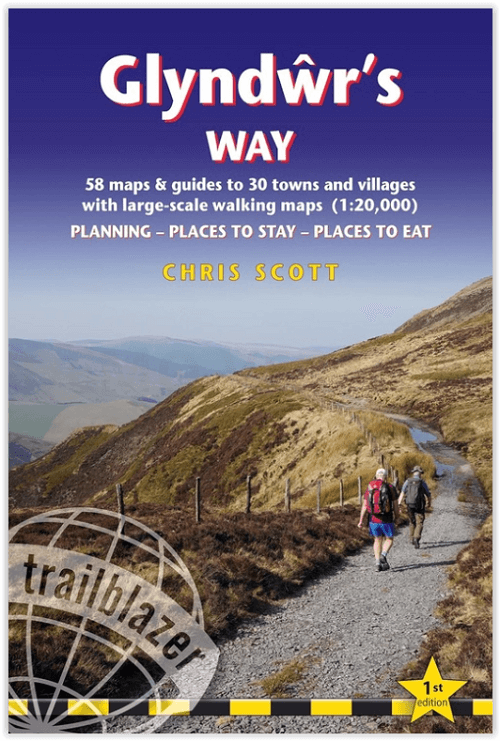
Wandelgids Glyndwr's Way Wales - Trailblazer
Van Knighton tot Welshpool - 216.5 Km

Korte omschrijving
Wandelgidsen Powys, Wales van Trailblazer Publications. Ideaal voor tochten in Wales.
Wandelgids Glyndwr's Way - Trailblazer Productomschrijving: Deze nieuwe omvat het 216 km lange National Trail in Wales in de voetsporen van Owain Glyndwr, de Welshe prins die in 1400 een ops...

Specificaties
- Uitgever: Trailblazer Publications
- ISBN-13: 9781912716326
- HOOFDCATEGORIEËN: Wandelgids
- Activiteiten: Wandelen, Hiking & Trekking
- Auteur: Chris Scott
- Regio: Powys, Wales
- Land: Wales
- Editie: 1
- Taal: Engels
- Reeks/Serie: National Trails, UK
Volledige omschrijving
Wandelgids Glyndwr's Way - Trailblazer
Productomschrijving: Deze nieuwe omvat het 216 km lange National Trail in Wales in de voetsporen van Owain Glyndwr, de Welshe prins die in 1400 een opstand tegen de Engelsen leidde en nu als held in de Welshe geschiedenis is verankerd. Het pad doorkruist een reeks open landbouwgronden en bossen en sluit aan op een ander Nationaal Pad, het Offa's Dyke Path, bij het begin in Knighton en het einde in Welshpool en loopt door Machynlleth, de zetel van het Welshe parlement van Glyndwr.
Engelse omschrijving: This new title in our British Walking Guides series covers the 134.5-mile (216.5km) National Trail in Wales following in the footsteps of Owain Glyndwr, the Welsh prince who led a rebellion against the English in 1400 and is now enshrined in Welsh history as a hero. Traversing a range of open farmland and forest, it links with another National Trail, Offa’s Dyke Path, at its start in Knighton and end in Welshpool and runs through Machynlleth, the seat of Glyndwr's Welsh parliament.
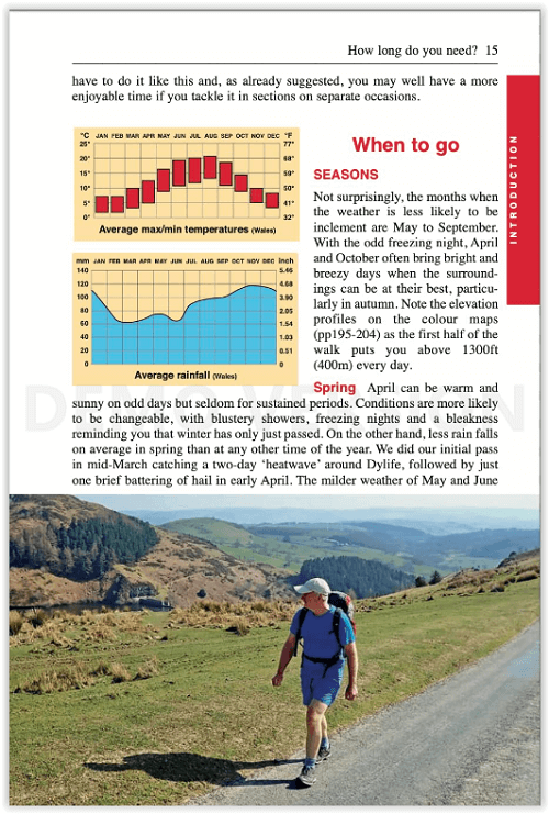
- 62 maps
- 60 colour photos
- 120mm x 180mm 5" x 7"
- Two-way guide researched in both directions: Knighton to Welshpool and Welshpool to Knighton. Route descriptions included for both directions.
- Includes 62 detailed walking maps: the largest-scale maps available – at just under 1:20,000 (8cm or 3-1/8 inches to 1 mile)
- Unique mapping features – walking times, directions, tricky junctions, places to stay, places to eat, points of interest.
- Itineraries for all walkers – whether hiking the entire route or sampling highlights on day walks or short breaks.
- Practical information for all budgets – what to see, where to eat, where to stay: B&Bs, hotels, campsites, bunkhouses, hostels and pubs.
- Overview mapping for stage sections (one per stage) in colour also including trail profiles
- With downloadable GPS/what3words waypoints
- Also includes Pumlumon Fawr Horseshoe side trip

Artikelen uit dezelfde regio
Wandelkaart 160 Brecon Beacons NP - Powys Wales - OSI • 9780319262580
Wandelkaart Brecon Beacons NP - Powys Wales Productbeschrijving: OS Landranger kaart 160 is een all purpose kaart volgepakt met informatie om u het gebied Brecon Beacons National Park in Zuid-Wales te helpen leren kennen. Het iconische landschap van Brecon Beacons staat vol bossen, watervallen, en de hoogste piek in zuidelijk Groot-Brittannië (Pen y Fan) die tot 886 meter stijgt. De regio …

Wandelkaart 147 Elan Valley & Builth Wells - Wales - OSI • 9780319474709
Wandelkaart Elan Valley & Builth Wells - Powys - OSI Productbeschrijving: De OS Landranger kaarten reeks heeft betrekking op Groot-Brittannië met 204 gedetailleerde kaarten, perfect voor dagtochten en korte pauzes. Elke kaart bevat alle informatie die u nodig heeft om dit lokaal gebied te leren kennen en omvat plaatsen van belang, toeristische informatie, picknickplaatsen en campings, plus…

Wandelkaart 188 Builth Wells & Llanfair-ym-Muallt - OSI • 9780319243817
Wandelkaart Builth Wells & Llanfair-ym-Muallt - Wales Productbeschrijving: Painscastle & Talgarth. 188 / Builth Wells & Llanfair-ym-Muallt, Wales - Kaart nummer 188 in de OS Explorer kaart reeks is ideaal voor het ontdekken van het bovenste gedeelte van de Wye Valley rond Builth Wells. De Wye Valley Walk recreatieve pad slingert zich naast de rivier Wye. Andere hoogtepunten van het ge…
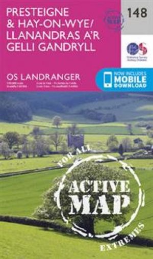
Wandelkaart 148 Presteigne & Hay-on-Wye - S. Wales - OSI • 9780319474716
Wandelkaart Presteigne & Hay-on-Wye - Powys - OSI Productbeschrijving: OS Landranger kaart 148 dekt Presteigne & Hay-on-Wye en omvat ook Norton, Glascwm, Kington, Weobly, Staunton Wye, Leominster en delen van de Offa's Dyke path, de Way of Glyndwrs en het Brecon Beacons National Park. De OS Landranger kaarten reeks heeft betrekking op Groot-Brittannië met 204 gedetailleerde kaarten, perfec…
Wandelkaart 161 Black Mountains & Brecon Beacons NP - OSI • 9780319474846
Wandelkaart 161- The Black Mountains & Brecon Beacons NP Productbeschrijving: Landranger kaart 161 toont Abergavenny en de Black Mountains. De Black Mountain range is fysiek gescheiden van de rest van de Brecon Beacons door de rivier Wye. Offa's Dyke path en Sugar Loaf mountain trekken veel wandelaars en adrenalinezoekers aan de iconische Welsh regio. U kunt ook een bezoek brengen aan de p…