
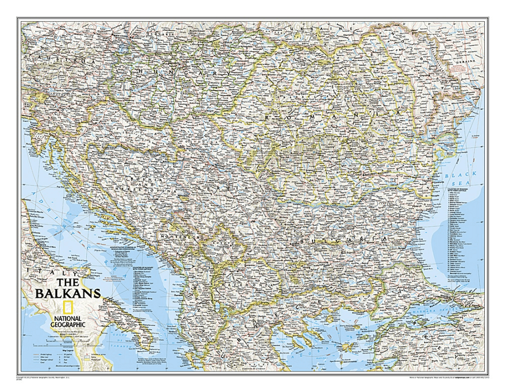
Plano Wandkaart Balkans 77 x 60 cm - Nat Geo
Geplastificeerd


Korte omschrijving
Wandkaart Balkans 77 x 60 cm - Nat Geo Productomschrijving: The Countries of the Balkans wallmap features thousands of place-names, political boundaries, national parks, and major infrastruc...

Specificaties
- Uitgever: National Geographic
- ISBN-13: 9781597754057
- HOOFDCATEGORIEËN: Wandkaarten Planokaart/opgerold
- Activiteiten: Wandkaarten
- Regio: Bulgarije, Kosovo, Balkan Zuid-Europa, Kroatië, Montenegro, Balkan, Servië, Balkan
- Land: Zuidoost-Europa
- Waterafstotende kaart: National Geographic, Geplastificeerd
- Schaal: 1:1948000
- Taal: Engels
- Reeks/Serie: Planokaart/opgerold
- Wandkaarten & Planokaarten: Wandkaarten & Planokaarten
Volledige omschrijving
Wandkaart Balkans 77 x 60 cm - Nat Geo
Productomschrijving: The Countries of the Balkans wallmap features thousands of place-names, political boundaries, national parks, and major infrastructure networks such as roads, canals, ferry routes, and railroads. The region's diverse terrain is detailed through shaded relief, coastal bathymetry, and symbols for water features and other landforms. Elevations of major peaks as well as depth soundings are expressed in meters. The signature Classic style map uses a bright, easy to read color palette featuring blue oceans and stunning shaded relief that has been featured on National Geographic wall maps for over 75 years.
The map covers: Albania, Austria, Bosnia and Herzegovina, Bulgaria, Croatia, Hungary, Kosovo, Macedonia, Moldova, Montenegro, Romania, Slovenia, as well as the outlying border countries of Greece, Italy, Slovakia, Serbia, Turkey and Ukraine.
It also includes listings for the counties of Hungary and Romania along with their respective capitals and the administrative divisions of Bosnia and Herzegovina.
Afmeting: 77 x 60 cm
Artikelen uit dezelfde regio
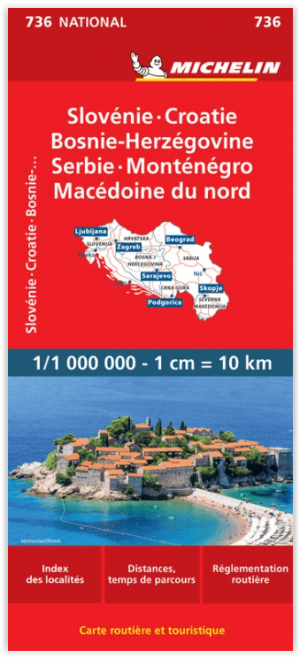
Landkaart Wegenkaart 736 Slovenië- Kroatië- Bosnië & Servië • 9782067171930
Wegenkaart Slovenië- Kroatië- Bosnië & Servië - Michelin Productomschrijving: Deze Nationale kaart van Slovenië- Kroatië- Bosnië- Servië & Macedonië, werd ontwikkeld, om zich snel uit de voeten wil maken, met plaatsnamenindex, en toeristische informatie, geven u alle elementen om dat werkelijkheid te maken. De kaarten zijn gemakkelijk leesbaar en gedrukt op sterk papier. De rode Michel…
Reisgids Croatia Kroatië - Mini Rough Guides • 9781835293928
Reisgids Croatia - Rough Guides Mini Productomschrijving: Compact, concise and packed full of essential information about where to go and what to do, this is an ideal on-the-move guide for exploring Croatia. From top tourist attractions like Dubrovnik, Plitvice Lakes National Park and Rab Town, to cultural gems, including exploring the Roman amphiteatre in Pula, swimming in a lake in stunn…
Wandelkaart Montenegro Mountains - Terraquest • 9788361155874
Wandelkaart Montenegro Mountains - Terraquest Productomschrijving: Een serie speciaal ontworpen voor liefhebbers van grote reizen en bergwandelingen. Omvat: Het Durmitor Nationaal Park - de Bjelasica Bergen - het Prokletije Nationaal Park - en de Komovi Bergen. Een gedetailleerde schaal en complete toeristische informatie om u te helpen bij het plannen van uw trekking. Dankzij het …

Reisgids Kosovo - Bradt travel guides • 9781804692462
Reisgids Kosovo - Bradt Productomschrijving: This new, fully updated fourth edition of Bradt’s Kosovo remains the only full-length, English-language guidebook to this Balkan land rich in cultural heritage and contemporary arts, and oozing generous hospitality and stunning scenery. This new edition is ideal for visitors and expats alike, offering maps, contacts and detailed information not…

Landkaart Wegenkaart 166 Kroatië Noord + Zuid - Freytag & Berndt • 9783707924626
Wegenkaart Kroatië Noord + Zuid - Freytag & Berndt Productomschrijving: Wegenkaartenset: 2 bladen in plastic hoes met infogids en top tips. De wegenkaartenset Kroatië 1:200.000 bestaat uit twee dubbelzijdig bedrukte wegen- en recreatiekaarten en een praktische infogids. Dankzij de gedetailleerde kaart en de nauwkeurige schaal kunt u ook zijwegen en rijwegen ontdekken die niet op overzi…