

Landkaart Wegenkaart South Africa: Baviaanskloof - Slingsby Maps
De Baviaanskloof- Cape Fold-gebergte - West-kaap Zuid afrika


Korte omschrijving
Wegenkaart Baviaanskloof South Africa - Slingsby Productomschrijving: South Africa: Baviaanskloof. Whether you’re a hiker, mountain biker or 4×4 enthusiast this is the map you need for ...

Specificaties
- Uitgever: Tracks4Africa
- ISBN-13: 9781920377502
- HOOFDCATEGORIEËN: Wegenkaart - Landkaart
- Activiteiten: Street/Road maps & city plans
- Regio: Zuid Afrika
- Land: Zuid-Afrika
- Toepasselijke bergketen: Cape Fold-gebergte, West-Kaap Zuid Afrika
- Schaal: 1:125000
- Editie: 5
- Taal: Engels
Volledige omschrijving
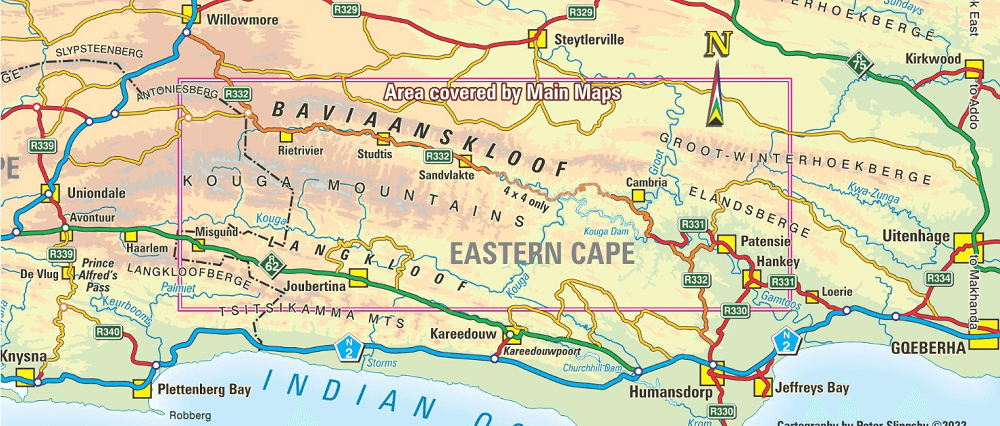
Wegenkaart Baviaanskloof South Africa - Slingsby
Productomschrijving: South Africa: Baviaanskloof.
Whether you’re a hiker, mountain biker or 4×4 enthusiast this is the map you need for your visit to the spectacular Baviaanskloof. The map is fully GPS-compatible and will enable you to explore this fabulous, rugged wilderness, its geological marvels, extraordinary flora and fauna, and the poignant reminders of its Khoisan past…
Edition #5 includes the new Leopard Trail and several interactive features, with brilliant new cover pic by Elke Losskarn.
Artikelen uit dezelfde regio

Stadskaart plattegrond Kaapstad Zuid Afrika - Borch • 9783866093805
Wandelkaart Kaapstad Zuid Afrika - Borch Productomschrijving: Our soft-laminated folded map of Cape Town in the 5th edition shows: Cape Town 1:15 000, Cape Peninsula 1:140 000, Cape Town and Region 1:635 000, Garden Route 1:3 000 000, Robben Island 1:40 000, South Africa administrative & time zones, Public Transport Cape Town. Borch Maps are easy to fold, durable and water-repellent with a…

Reisgids Botswana & Namibia - Lonely Planet • 9781787016651
Botswana & Namibia - Lonely Planet Productomschrijving: Ooit het rauwe, wilde hart van Afrika willen ervaren? Botswana en Namibië wemelen van de wilde dieren en zijn weelderig begroeid met buitengewone landschappen. Lonely Planet brengt je naar het hart van Botswana & Namibië, met geweldige reiservaringen en het beste planningsadvies. Lonely Planet Botswana & Namibië is je paspoort voo…

Reisgids Zuid-Afrika - Insight Guides (NL) • 9789493423077
Reisgids Zuid-Afrika - Insight Guides Productomschrijving: Zuid-Afrika is een van de meest geliefde vakantiebestemmingen en heeft veel te bieden. Wildreservaten met de ‘Big-5’, zon, strand en schitterende landschappen. De auteurs en fotografen laten u op de bekende, onovertroffen en veelvuldig bekroonde Insight Guide-wijze kennismaken met dit spectaculaire land. In de eerste hoofdstukk…
Reisgids South Africa - Lesotho & Eswatini - Rough Guides • 9781839059780
South Africa - Lesotho & Eswatini - Rough Guides Productomschrijving: Ontdek Zuid-Afrika, Lesotho en Swaziland met de meest scherpzinnige en onderhoudende gids op de markt. Of je nu van plan bent om op safari te gaan in het Kruger National Park, de heerlijke wijnen van de Westkaap te proeven of het dorp te verkennen waar Nelson Mandela opgroeide, The Rough Guide to South Africa, Lesotho & …
Landkaart Wegenkaart Garden Route NP Zuid Afrika - Slingsby Maps • 9781920377472
Wegenkaart Garden Route NP, West kaap Zuid Afrika - Slingsby Productomschrijving: Brand new 11th edition of the FIRST and still the BEST Garden Route map … Now thoroughly updated. From Witsand and Heidelberg in the west, this all new map has been extended eastwards through Mossel Bay, George, Knysna and Plett to include Jefferys Bay and the Gamtoos RIver Mouth – with fully updated Tou…