

Landkaart Wegenkaart Cape Town Day Drives - Slingsby Maps
Citrusdal - Laingsburg - Stilbaai - Velddrif - Aurira - Piketberg

Korte omschrijving
Wegenkaart Cape Town Day Drives - Slingsby Productomschrijving: Day Drives from Cape Town. Our Day Drives from Cape Town map is the most comprehensive map available of the heartland of the ...

Specificaties
- Uitgever: Tracks4Africa
- ISBN-13: 9781920377342
- HOOFDCATEGORIEËN: Wegenkaart - Landkaart
- Activiteiten: Street/Road maps & city plans
- Regio: Capetown Zuid Afrika, Zuid Afrika
- Land: Zuid-Afrika
- Schaal: 1:425000
- Editie: 3
- Taal: Engels
Volledige omschrijving
Wegenkaart Cape Town Day Drives - Slingsby
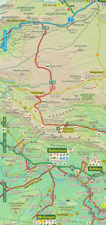
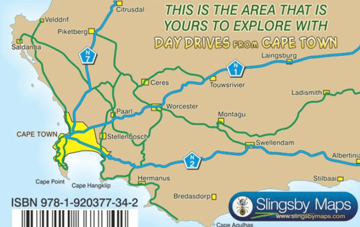
Productomschrijving: Day Drives from Cape Town. Our Day Drives from Cape Town map is the most comprehensive map available of the heartland of the Western Cape. The map shows all the roads, towns and relief of the area from Cape Town north to Citrusdal, north-east to Laingsburg and east to Stilbaai /
Albertinia: all destinations within easy motoring reach of Cape Town. The most important tourist features are included, with ‘smiling faces’ indicating the most scenic routes. This is the third edition of this popular general guide, now extended eastwards to make it even more useful than before!
One side of this double-sided map covers the area from Cape Town, up the west coast to Velddrif and across via Aurira and Piketberg to Citrusdal and the Kouebokkeveld. Ceres, Worcester, Stanford and Gansbaai mark the eastern edge of Side 1, which also includes a useful enlargement of the Cape Peninsula, at a scale of 1:200 000.
Turn over the map [there is a small, useful overlap] and the map will take you via Touwsrivier to Laingsburg and the southern Tankwa. Travel south via Calitzdorp, Ladismith and Riversdale to Stilbaai, and then west back to Cape Agulhas, Napier, McGregor and Robertson – with all the great destinations in between.
- All roads ( tar and gravel) are shown with accurate mileages between major junctions.
- Full GPS details are shown at every major road-junction in DDMMSS format.
- Particularly scenic routes are marked with smiley faces
- Major mountain biking, horse riding, nature reserves, river rafting, golf and hiking facilities, farm stalls, historic sites.
- Tourism information and all kinds of accommodation from out-of-town lodges to back packers and campsites are shown.
Artikelen uit dezelfde regio

Stadskaart plattegrond Kaapstad Zuid Afrika - Borch • 9783866093805
Wandelkaart Kaapstad Zuid Afrika - Borch Productomschrijving: Our soft-laminated folded map of Cape Town in the 5th edition shows: Cape Town 1:15 000, Cape Peninsula 1:140 000, Cape Town and Region 1:635 000, Garden Route 1:3 000 000, Robben Island 1:40 000, South Africa administrative & time zones, Public Transport Cape Town. Borch Maps are easy to fold, durable and water-repellent with a…
Wandelkaart Afrika Zuid-Afrika - 130 x 98 - Tracks-4-Afrika • 9781776322831
Wandelkaart Zuid-Afrika - 130 x 98 - Slingsby Maps Productomschrijving: The Tracks4Africa Southern Africa Wall Map is printed to a scale of 1:2,5million and provides a surprising amount of detail to the self-drive traveller. The map is perfect for macro planning of road trips across Southern Africa up to Southern Angola. The map indicates major and secondary roads, parks, towns and a good…
Landkaart Wegenkaart Mozambique & Malawi - Tracks4Afrika • 9781776322886
Wegenkaart Mozambique & Malawi Productomschrijving: Mozambique & Malawi tracks Kenmerkend voor deze kaart is de combinatie van geografische informatie en GPS verwijzingen, ideaal voor 4x4 routes. Verder bevat de kaart een plaatsnamenregister, aparte kaartjes van de Nationale parken en stadsplannen van de belangrijkste steden uit de regio. Deze kaart bied u het perfecte instrument…

Wandelkaart Afrika Zuid-Afrika - 98 x 130 - Tracks-4-Afrika • 9780620907293
Wandelkaart Afrika Zuid-Afrika - Slingsby Productomschrijving: The Tracks4Africa Wall Map is printed to a scale of 1:4million and laminated on both sides and provides a surprising amount of detail to the self-drive traveller. The map is perfect for macro planning of extended road trips across the African continent up to Ethiopia in the east and Gabon in west. The map indicates major and s…

Landkaart Wegenkaart 95 Zimbabwe Zuid-afrika - Slingsby Maps • 9781776322732
Wegenkaart Zimbabwe Zuid-afrika - Slingsby Productomschrijving: Kenmerkend voor deze kaart is de combinatie van geografische informatie en GPS verwijzingen, ideaal voor 4x4 routes. Verder bevat de kaart een plaatsnamenregister, aparte kaartjes van de Nationale parken en stadsplannen van de belangrijkste steden uit de regio. Deze kaart bied u het perfecte instrument om uw volgende reis…