

Fietsgids Lake District cycling - Cicerone
The Fred Whitton Challenge, week-long tours and day rides


Korte omschrijving
Fietsgidsen Cumbria & Lake District, England van CICERONE Press. Ideaal voor tochten in England.
Lake District cycling - Cicerone Productomschrijving: Fietsgids over een 5-daagse fietstocht door het Lake District, met 2 opties per dag tot een totaal van 299 km en bijna 5000 meter klimme...

Specificaties
- Uitgever: CICERONE Press
- ISBN-13: 9781786311887
- HOOFDCATEGORIEËN: Fietsgids
- Activiteiten: Fietsen / VTT / MTB
- Auteur: Richard Barrett
- Regio: Cumbria & Lake District, England
- Land: England
- Nationale parken: Lake District NP, Cumbria England
- Editie: 2
- Taal: Engels
- Fietsen: Fietsen in het Buitenland
- De Nationale Parken: Lake district National Park, England
- Iconische Wandelroutes: Lake district, Cumbria England
- Wandelen in de Bossen & natuurgebieden van Europa: Lake district, England
Volledige omschrijving
Lake District cycling - Cicerone
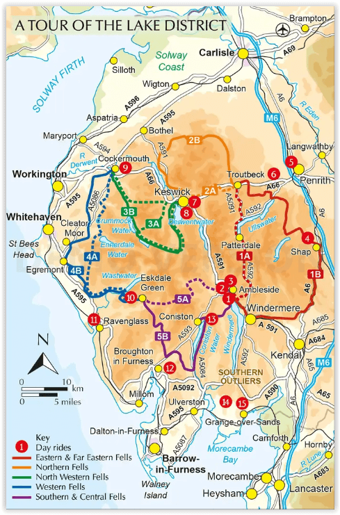
Productomschrijving: Fietsgids over een 5-daagse fietstocht door het Lake District, met 2 opties per dag tot een totaal van 299 km en bijna 5000 meter klimmen, en 15 pittige dagritten vanuit Keswick, Ambleside, Penrith en bases in het zuidwesten en zuidoosten van het nationale park. Met een overzicht van andere tochten en de Fred Whitton Challenge-rit (180 km over 7 iconische passen).
Engelse omschrijving: Guidebook to a 5-day cycle tour of the Lake District, with 2 options each day up to a total of 186 miles and almost 5000m of ascent, and 15 tough day rides from Keswick, Ambleside, Penrith and bases to the southwest and southeast of the National Park. With outlines of other tours and the Fred Whitton Challenge ride (112 miles over 7 iconic passes).
Seasons:
The best time to go touring in the Lake District is between April and October, when the days are longer and the weather is at its best. But even then, you will undoubtedly get wet and experience blustery days. So be prepared for them. As a general rule always plan your route so that you are riding south to north with the prevailing south westerly winds.
Centres:
Ambleside Grasmere Troutbeck Shap Penrith Stainton Keswick Cockermouth Eskdale Green Ravenglass Broughton in Furness Grizedale Cartmel Grange-over-Sands Bassenthwaite Buttermere.
Difficulty:
Each tour stage and day ride and is graded on two criteria: distance with rides categorised as short, medium or long, and total ascent with rides categorised as easy, moderate, hard or challenging. Easy - smooth pedalling with gentle inclines Moderate - undulating with an occasional steady climb, but nothing to get you out of the saddle Hard - involves some hard climbs with gradients up to 10 per cent Challenging - long steep ascents or multiple short sharp gradients that will most definitely hurt. Inevitably, the majority of rides fall into the latter categories.
Must See:
Incredible scenery and rare wildlife - the Lake District is England's largest national park, local craft breweries, local foods, Kirkstone Pass, Hardknott Pass, the impressive panorama of Yewbarrow, Kirkfell, Great Gable and Scafell Pike from Wasdale Head.

Artikelen uit dezelfde regio
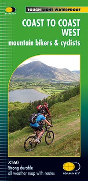
Fietskaart Coast to Coast West & St Bees to Kirkby - Harvey maps • 9781851375318
Fietskaart- Coast to Coast West & St Bees to Kirkby - Harvey maps Productomschrijving: De route van kust tot kust, is bedekt met twee kaarten. De doortocht van kust naar kust is ongeveer 200 mijl. Er is geen één definitieve route. Deze kaarten suggereren twee belangrijkste alternatieven, St Bees naar Robin Hoods Bay (bedacht door Tim Woodcock) of Bicester aan Wykeham (bedacht door pedaal N…
Reisgids The Lake District - Edicola • 9789492920621
Reisgids - The Lake District - Edicola Productomschrijving: Leuke wandelroutes, pittoreske dorpjes, adembenemende vergezichten, ambachtelijke etenswaren en dranken, ruige bergtoppen, sprankelende meren, watervallen en beekjes. Verken het meest populaire nationale park van Engeland, ga ‘off the beaten track’ en creëer herinneringen voor de rest van je leven. Zwemmen in een verlaten bergmeer…

Wandelkaart Lake District National Park XT40 - Harvey Maps • 9781851376865
Wandelkaart Lake District XT40 - Harvey Maps Productomschrijving: Een nieuwe generatie kaarten van stevig polyethyleen. Ze zijn stevig, duurzaam en 100% waterdicht, compact en licht om mee te nemen. Deze all weather Britse bergkaart voor klimmers, bergwandelaars, bergbeklimmers en mountainbikers is uitgegeven door HARVEY in samenwerking met de British Mountaineering Council. De beroemd…

Wandelgids Lakeland short walks book 3- West Lakeland - Cicerone • 9781852843083
Wandelgids -Lakeland short walks book 3- West Lakeland - Cicerone Routes bedekken Rydal, Grasmere, Langdale, little Langdale, Coniston, Torver en het zuiden, Grizedale, Satterthwaite, e.a. Productomschrijving: Een gids van korte wandelingen in het zuiden van het engelse Lake District, het VK, de derde van deze drie-delige lake landserie. Routes bedekken: Rydal, Grasmere, Langdale, …
Wandelgids Nord England Lake District & Yorkshire Dales - Rother • 9783763314522
Nord England Lake District & Yorkshire Dales - Rother Productomschrijving: Der Norden von England ist hierzulande als Ziel für einen Wanderurlaub nicht allzu bekannt, dies aber völlig zu Unrecht. Nicht umsonst gehören Lake District und Yorkshire Dales zu den bekanntesten Wanderregionen Großbritanniens und können selbst anspruchsvolle Wanderer begeistern. Doch auch hinter weniger bekannten…