

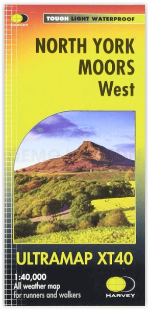
Wandelkaart North York Moors West XT40 - Harvey Maps
Omvat de populaire Hambleton Hills en Cleveland Hills
Korte omschrijving
Wandelkaarten Yorkshire, England van HARVEY MAPS. Ideaal voor tochten in England.
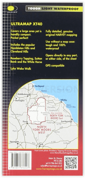
Wandelkaart North York Moors West - Harvey Maps Productomschrijving: Omvat een groot gebied maar is praktisch en compact, zakformaat. Gedetailleerde kaart voor lopers en wandelaars van het w...

Specificaties
- Uitgever: HARVEY MAPS
- ISBN-13: 9781851376223
- HOOFDCATEGORIEËN: Wandelkaart
- Activiteiten: Wandelen, Hiking & Trekking
- Regio: Yorkshire, England
- Land: England
- Nationale parken: North York Moors NP, England
- Schaal: 1:40000
- Taal: Engels
- Reeks/Serie: National Trails, UK, Superwalker XT40, Harvey Maps
- De Nationale Parken: North Yorkshire Moors National Park, England
- De Engelse Graafschappen: North Yorkshire
Volledige omschrijving
Wandelkaart North York Moors West - Harvey Maps
Productomschrijving: Omvat een groot gebied maar is praktisch en compact, zakformaat. Gedetailleerde kaart voor lopers en wandelaars van het westelijk gedeelte van het Nationaal Park North York Moors.
Omvat: de populaire Hambleton Hills en Cleveland Hills.
- Roseberry Topping, Sutton Bank en de White Horse.
- De Lyke Wake Walk is aangeduid.
- Heeft de voordelen van zijn grotere broers:
- Gebruik zonder plastic hoesje: stevig en 100% waterbestendig
- Opent direct aan beide zijden van het blad
Locatie op kaart
Artikelen uit dezelfde regio

Mountainbikegids Yorkshire Dales mountain biking - Cicerone • 9781852846763
Mountainbikegids - Yorkshire Dale mountain biking - Cicerone Productomschrijving: Een handige gids over 30 korte, middellange, lange en volledig-dag MTB routes over het Yorkshire Dales National Park, de speeltuin van de bergfietser van Noord-Engeland. Circulaire ritten bezoeken de grote valleien en nemen lussen rond twee van de drie pieken, Whernside en Pen-y-Gent. Kies een route door midd…
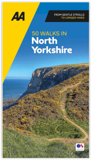
Wandelgids 50 walks in North Yorkshire - AA Publi. • 9780749583781
50 walks in North Yorkshire - AA Publishing Productomschrijving: North Yorkshire, met zijn uitgestrekte landschappen en rijke geschiedenis, is een paradijs voor wandelaars. De wandelgids "50 Walks in North Yorkshire" biedt routes door enkele van de mooiste plekken in het Verenigd Koninkrijk. Wat Kun Je Er Vinden? Adembenemende Landschappen: Yorkshire Dales en North York Moors b…

Wandelkaart OL21 - South Pennines - Yorkshire - OSI • 9780319469392
Wandelkaart South Pennines - Yorkshire England Omvat ook: Burnley, Hebden Bridge, Keighley & Todmorden Productbeschrijving: Kaart nummer OL21 in de OS Explorer kaarten reeks omvat de Pennines, Burnley, Hebdem brug, Todmorden & Keighley. The OS Explorer kaart voor Zuid-Pennines is beschikbaar in zowel de standaard papieren versie en weerbestendige 'Actief' versie. Kaart nummer OL21i…

Fietsgids West Yorkshire Mountain Biking - Vertebrate Publ. • 9781906148157
West Yorkshire Mountain Biking - Vertebrate Productomschrijving: West Yorkshire Mountain Biking - South Pennine Trails features 23 of the best mountain bike rides in West Yorkshire, between 10.5km and 32km in length, suitable for all levels of mountain bikers. Written by local expert and MTB journalist Benjamin Haworth, each route features clear and easy to use Ordnance Survey 1:50,000 map…

Trailrunning gids Yorkshire Dales NP - Cicerone • 9781852849221
Trailrunning gids, 40 runs in the National Park-Three Peaks Productomschrijving: Guidebook to 40 great trail and fell runs in the Yorkshire Dales National Park. Ranging from 5 to 24 miles, the graded runs start from bases such as Hawes, Settle, Ingleton, Dent, Sedbergh, Malham and Grassington and take in the region's diverse delights, from castles and waterfalls to iconic mountains such a…