

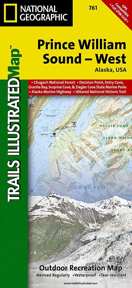
Wandelkaart 761 Prince William Sound West - Alaska - Nat Geo
De Prince William Sound is een deel van de Golf van Alaska
Korte omschrijving
Wandelkaarten Alaska, USA van National Geographic. Ideaal voor tochten in Verenigde Staten van Amerika (USA).
TOPO Wandelkaart 761 - Prince William Sound, West - Alaska - National Geographic Productomschrijving: De Prince William Sound is een deel van de Golf van Alaska gelegen ten zuiden van de Ame...

Specificaties
- Uitgever: National Geographic
- ISBN-13: 9781566954204
- HOOFDCATEGORIEËN: Wandelkaart
- Auteur: National Geographic
- Regio: Alaska, USA
- Land: Verenigde Staten van Amerika (USA)
- TOPO's & Stafkaarten: Topografisch wandelen
- Schaal: 1:110000
- Taal: Engels
Volledige omschrijving
TOPO Wandelkaart 761 - Prince William Sound, West - Alaska - National Geographic
Productomschrijving: De Prince William Sound is een deel van de Golf van Alaska gelegen ten zuiden van de Amerikaanse staat Alaska. De Prince William Sound heeft een kustlijn van een kleine 5000 kilometer en ligt ten oosten van het Kenai-schiereiland. In het oosten, noorden en westen wordt de Prince William Sound omgeven door de Chugach Mountains. De omgeving is bezaaid met wandelpaden die de schitterende natuur van dit deel van wereld in het licht brengen.
Engelse omschrijving: Prince William Sound is a dramatic marine landscape of endless coastline, rugged mountains, and tidewater glaciers known for calving enormous chunks of ice into the sea. Expertly researched and created in partnership with local land management agencies, National Geographic's Trails Illustrated map of Prince William Sound - West provides an unparalleled tool for exploring this breathtaking region. Key areas of interest include Whittier, Port Nellie Juan, Chugach National Forest, Nellie Juan-College Fiord Wilderness Study Area, and Harriman, Blue, and College fiords. Chenega, Knight, Latouche, Elrington, Evans, Bainbridge, Culross, Esther, and Perry islands are also shown.
Kayaking and boating are popular activities in Prince William Sound and state marine parks abound including South Esther Island, Granite Bay, Bettles Bay, Surprise Cove, Decision Point, Entry Cove, Ziegler Cove, Thumb Cove, Safety Cove, Sandspit Point, Sunny Cove, Driftwood Bay, and Horseshoe Bay. The map features detailed topography with shaded relief and contour lines; clearly defined, color-coded boundaries of state marine parks, wildlife areas, and native corporation lands; safety information; elevations for summits, passes, and some lakes; and depth soundings. Recreation features are clearly marked, including campgrounds, public use cabins, kayak landings, seaplane bases, selected anchorages, trailheads, and lighthouses. Every Trails Illustrated map is printed on "Backcountry Tough" waterproof, tear-resistant paper. A full UTM grid is printed on the map to aid with GPS navigation.
Other features found on this map include: Blying Sound, Cape Junken, Chugach National Forest, College Fiord, Day Harbor, Ellsworth Glacier, Inner Lake George, Kings Bay, Knight Island, Knight Island Passage, Knik Glacier, Montague Strait, Nellie Juan River, Perry Island, Port Bainbridge, Port Wells, Sargent Icefield, Unakwik Inlet, Upper Lake George.
Locatie op kaart
Overzichtskaarten

NAT GEO Alaska trails map
NAT GEO Alaska trails map
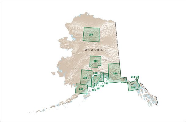
Producten op de overzichtskaart
Klik op een product om naar de detailpagina te gaan.
- Wandelkaart 248 Katmai NP- Alaska - Nat Geo
- Wandelkaart 254 Chilkoot Trail - Klondike Gold Rush - Nat Geo
- Wandelkaart 255 Glacier Bay NP- Alaska - Nat Geo
- Wandelkaart 257 Gates of the Arctic NP- Alaska - Nat Geo
- Wandelkaart 760 Kenai National Wildlife Refuge - Alaska - Nat Geo
- Wandelkaart 761 Prince William Sound West - Alaska - Nat Geo
- Wandelkaart 763 Kachemak Bay State Park - Alaska - Nat Geo
Artikelen uit dezelfde regio

Wandelkaart 248 Katmai NP- Alaska - Nat Geo • 9781566952903
TOPO Wandelkaart 248 - Katmai NP- Alaska - Nat Geo Productomschrijving: Katmai National Park is een Amerikaans nationaal park in het zuiden van de staat Alaska, gelegen op het Alaska-schiereiland. Het ligt ongeveer 450 kilometer ten zuidwesten van de stad Anchorage. Het gebied is alleen per boot of vliegtuig te bereiken. Engelse omschrijving: Known for its large population of bears an…

Wanderlkaart 222 Denali NP- Alaskan Range - Alaska - Natge • 9781566953283
TOPO Wanderlkaart 222 - Denali NP- Alaskan Range - Nat Geo Productomschrijving: Denali National Park and Preserve is een Amerikaans nationaal park, in het binnenland van Alaska. In centraal Denali, ligt de hoogste berg van noord Amerika. Compleet gezien is het park een dikke 24,464 km2 groot, die groter is dan West-Vlaanderen. Het Denali landschap is een mix van bos op zijn lager gelegen …

Arctic, A Guide to Coastal Wildlife - Bradt travel guides • 9781804693414
Arctic, A Guide to Coastal Wildlife - Bradt Productomschrijving: This extensively updated fifth edition of Bradt's The Arctic is an engagingly written and beautifully illustrated full-colour guidebook to some of the world's most exciting wildlife. Designed with expedition-cruise passengers in mind, it is an ideal companion both on board and ashore, providing fascinating accounts of the mos…
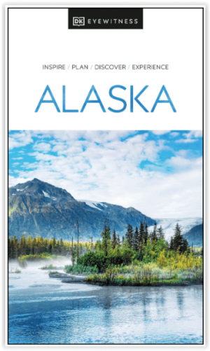
Reisgids Alaska - Eyewitness • 9780241411520
Reisgids Alaska - Eyewitness Productomschrijving: Tour the mighty Mendenhall Glacier, ride the Alaska Marine Highway or brave the cold to catch a glimpse of the mesmerising Northern Lights (Aurora Borealis): everything you need to know is clearly laid out within colour-coded chapters. Discover the best of Alaska with this indispensable travel guide. Inside DK Eyewitness Travel Guide Al…

Klimgids Denali - Mt McKinley - Rucksack reades • 9781898481539
Klimgids Denali - Mt McKinley - Summit of North America Productomschrijving: Met zijn 6194 m (20,320 ft) is Denali (Mt McKinley) de hoogste berg in Noord-Amerika. De Arctische latitude zorgt voor extreme weersomstandigheden en de afgelegen wildernis van Alaska betekent dat klimteams zelfstandig en ervaren moeten zijn. De auteur richte zich op de westelijke Buttress route die wordt gebruikt…