

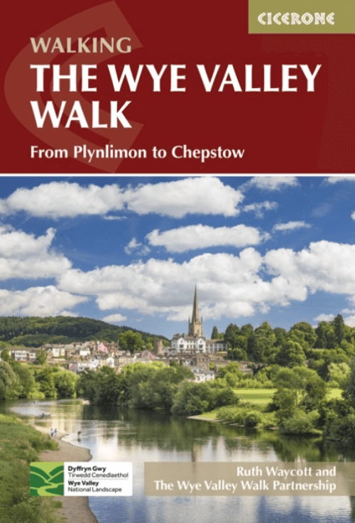
Wandelgids The Wye Valley walk - Welsh Borders - Cicerone
Door het Cambriumgebergte in Wales - Chepstow to Plynlimon
Korte omschrijving
Wandelgidsen South Wales van CICERONE Press. Ideaal voor tochten in Wales en England.
The Wye Valley walk along the Welsh Borders - Cicerone Productomschrijving: De Wye Valley Walk volgt de rivier de Wye over een afstand van 218 Km door het het Cambriumgebergte in Wales lang ...

Specificaties
- Uitgever: CICERONE Press
- ISBN-13: 9781786311986
- HOOFDCATEGORIEËN: Wandelgids
- Activiteiten: Wandelen, Hiking & Trekking
- Auteur: Ruth Waycott
- Regio: South Wales
- Land: England, Wales
- Lange afstand wandelroutes: Wye Valley walk, Welsh borders Wales (218 Km)
- Editie: 2
- Taal: Engels
Volledige omschrijving
The Wye Valley walk along the Welsh Borders - Cicerone
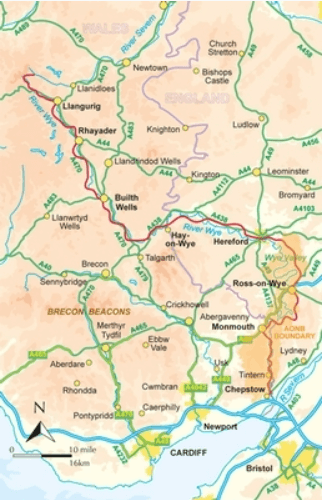
Productomschrijving: De Wye Valley Walk volgt de rivier de Wye over een afstand van 218 Km door het het Cambriumgebergte in Wales lang de grenzen van Wales. De route begint in Chepstow en volgt de Wye vallei tot aan de hellingen van Plynlimon, Powys, en duurt meestal 10 dagen. De Wye Valley Walk is een perfecte mix van rivier- en bergwandelingen, geschikt voor elke redelijk fitte wandelaar.
Engelse omschrijving: The Wye Valley Walk follows the River Wye for 136 miles through the beautiful and varied landscape of the Welsh borders. Typically taking 10 days to walk, the route starts in Chepstow and follows the Wye valley to the slopes of Plynlimon, Powys. The Wye Valley Walk is a perfect mix of river and hill walking, suitable for any reasonably fit walker.
Seasons:
Accessible at all times of the year but spring is best for watching birdlife and spring flowers, autumn shows the woods at their best and winter widens the views; the walk can be muddy during rainy spells and the river can flood making certain stretches impassable.
Centres:
Chepstow, Monmouth, Ross-on-Wye, Hereford, Hay-on-Wye, Builith Wells, Rhayader
Difficulty:
The Wye Valley Walk has some hilly sections but is suitable for any reasonably fit walker.
Must See:
Chepstow Castle, Angidy Valley, Tintern Abbey, Symonds Yat, Goodrich Castle, Hereford Cathedral, Hay-on-Wye, Hafren Forest, Plynlimon.

Artikelen uit dezelfde regio
Wandelgids 50 walks in the Brecon Beacons & South Wales - AA • 9780749583705
Wandelgids Brecon Beacons & South Wales - AA Productomschrijving: De Brecon Beacons in Wales vormen een waar paradijs voor wandelaars. Met zijn uitgestrekte landschappen, ruige bergen en diepe valleien biedt dit nationale park meer dan genoeg om de avontuurlijke wandelaar bezig te houden. Stel je voor dat er 50 wandelroutes zijn, elk met hun eigen charme en uitdaging, variërend van eenvoud…

Wandelkaart 166 Rhondda & Merthyr Tydfil - OSI • 9780319243596
Wandelkaart Rhondda & Merthyr Tydfil - South Wales Productbeschrijving: Kaart nummer 166 in de OS Explorer kaart reeks is de ideale kaart voor het ontdekken van de enorme ruimte van Rhondda en Merthyr Tydfil in Zuid-Wales. Net ten zuiden van de Brecon Beacons heeft dit gebied prachtige natuurschoon en vele wandelingen om te waarderen. Hoogtepunten van het gebied zijn onder andere: Aberdare…

Wandelkaart 198 Cardigan & New Quay- South Wales - OSI • 9780319470701
Wandelkaart Cardigan & New Quay - Aberaeron South Wales Productbeschrijving: Deze ' dubbel zijdige OS Explorer kaart 198 dekt Cardigan (Aberteifi) in het westen tot Aberaeron in het Oosten in Mid Wales. De Ceredigion Coast Path (Llwybr Arfordir Ceredigion) start vanaf hier, en geeft gemakkelijke toegang tot de kust. De OS Explorer kaart voor Cardigan & New Quay is beschikbaar in zowel de s…

Wandelkaart 152 Newport & pontypool South Wales - OSI • 9780319470244
Wandelkaart Newport & pontypool - South Wales Productbeschrijving: OS Explorer kaart 152 toont Pontypool aan Newport en de monding van de Severn. Dit gebied is zeer belangrijk voor wilde dieren, met veel van het estuarium die als een site van bijzonder wetenschappelijk belang word aangewezen. De OS Explorer kaart voor Newport & Pontypool is beschikbaar in zowel de standaard papieren versie…
Wandelkaart OL13 - Brecon Beacons NP - Eastern area - OSI • 9780319469316
Wandelkaart Brecon Beacons NP - Eastern area South Wales Omvat het oostelijke deel! Productbeschrijving: Van Blaina in het zuiden bij hay-on-Wye in het noorden, betreft dit gebied de Black Mountains en deel van een aantal bekende nationale routes en recreatieve paden zoals, de Beacons way, Herefordshire Trail, Offa's Dyke Path & Taff Trail. De Brecon Beacons biedt een breed scala aan b…