

Wandelgids Park Rangers Favourite Walks Peak District - Collins
Peak District National Park


Korte omschrijving
Wandelgidsen Derbyshire & Peak District, England van HarperCollins Publishers. Ideaal voor tochten in England.
Park Rangers Favourite Walks Peak District - Collins Productomschrijving: Wandelgids voor het Peak District National Park, met 20 van de beste routes uitgekozen door de parkwachters. Elke wa...

Specificaties
- Uitgever: HarperCollins Publishers
- ISBN-13: 9780008439125
- HOOFDCATEGORIEËN: Wandelgids
- Activiteiten: Wandelen, Hiking & Trekking
- Regio: Derbyshire & Peak District, England
- Land: England
- Nationale parken: Peak District NP, Derbyshire UK
- Taal: Engels
- Reeks/Serie: Park Rangers Favourite Walks, HarperCollins
- De Nationale Parken: Peak District Nationaal Park, England
- De Engelse Graafschappen: Derbyshire, South Yorkshire
Volledige omschrijving
Park Rangers Favourite Walks Peak District - Collins
Productomschrijving: Wandelgids voor het Peak District National Park, met 20 van de beste routes uitgekozen door de parkwachters. Elke wandeling varieert in lengte van 2 tot 10 km en kan worden voltooid in minder dan 4 uur.
Engelse omschrijving: Walking guide to the Peak District National Park, with 20 best routes chosen by the park rangers. Each walk varies in length from 2 to 10 km and can be completed in less than 4 hours.
- Walks from 2 to 10km
- Detailed description for each walk with highlights clearly marked on the map along with an accompanying map and photographs
- General information about the National Park plus basic advice on walking

Artikelen uit dezelfde regio

Wandelgids Classic Day Walks in the Peak District - Vertebrate • 9781906148492
Classic Day Walks in the Peak District - Vertebrate Productomschrijving: Day Walks in the Peak District – 20 classic circular routes features 20 circular walks, between 8.1 and 12.1 miles (13km and 19.5km), suitable for hillwalkers of all abilities. Local authors Norman Taylor and Barry Pope share walks in their favourite areas of the Peak District National Park including Chatsworth, Chee …
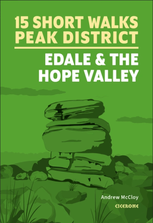
Wandelgids Peak District, Edale and the Hope Valley - Cicerone • 9781786312587
Peak District National Park - Edale and the Hope Valley - Cicerone Productomschrijving: Would you like to explore the best of Edale and the Hope Valley in the Peak District? This guidebook covers 15 of the best short walks in the area, including Hollins Cross and Mam Tor, Castleton, Ladybower Reservoir, Stanage Edge and North Lees, Kinder Scout and Castleton. Why choose this guidebook?…

Wandelgids Peak Bagging in Peak District NP - Vertebrate Publ. • 9781839812675
Peak Bagging in Peak District NP - Vertebrate Productomschrijving: This number includes 32 routes designed to complete the best 121 Peak District peaks and Ethels (like the Scotisch Munro's) in the most efficient way. In Peak Bagging Peak District, local author Anna Paxton guides you to 121 of the most rewarding summits in the national park, including the 74 accessible Ethels plus 47 other…

Wandelkaart XT25 Peak District Central - Harvey Maps • 9781851376537
Wandelkaart Peak District Central - Harvey Maps Productomschrijving: Gedetailleerde kaart voor bergwandelaars in het hart van het Peak District National Park. Het Peak District National Park is een zeer heuvelrijk landschap ten zuiden van het Penninisch Gebergte in het noorden van Engeland. Het gebied is beschermd. Omvat: Edale, Kinder Scout, de Gritstone Edges en Ladybower Reservoir. …

Wandelgids Peak District - 50 walks guide - AA Publishing • 9780749583262
Peak District - 50 walks guide - AA Publishing Productomschrijving: Wandelen is een van de favoriete vrijetijdsbestedingen van Groot-Brittannië. Deze AA gids - 50 wandelingen in het Peak District, bevat een verscheidenheid aan uitgestippelde wandelingen van twee tot tien mijl, geschikt voor alle niveaus. Het boek bevat alle praktische details die je nodig hebt, vergezeld van fascinerende a…