

Wegenatlas Britain & Ireland road atlas A5-formaat - Collins
Easy-to-use, handy A5 sized road atlas with lie-flat spiral


Korte omschrijving
Wegenatlas Britain & Ireland road atlas - Collins Productomschrijving: This easy-to-use, handy A5 sized road atlas with popular lie-flat spiral binding features extremely clear route planni...

Specificaties
- Uitgever: HarperCollins Publishers
- ISBN-13: 9780008719227
- HOOFDCATEGORIEËN: Wegenatlas
- Activiteiten: Street/Road maps & city plans
- Regio: Engeland, Ierland, Schotland, Wales
- Land: England, Ierland, Schotland, United Kingdom, Great Britain, Wales
- Taal: Engels
- Reeks/Serie: Wegenatlassen
Volledige omschrijving
Wegenatlas Britain & Ireland road atlas - Collins
Productomschrijving: This easy-to-use, handy A5 sized road atlas with popular lie-flat spiral binding features extremely clear route planning maps of Britain and Ireland and fits neatly into your glove box or bag. The atlas has been fully updated.
The maps of Britain are at 9.9 miles to 1 inch (1:625,000) and the whole of Ireland is covered at 15.8 miles to 1 inch (1:1,000,000). There are also a selection of more detailed urban area maps at 4.5 miles to 1 inch (1:285,000) to aid route planning in these busy areas.
Main features:
• Road maps that focus on the main roads, motorways and settlements.
- More detailed maps of London, Manchester, Merseyside and West Midlands.
- Park & Ride locations (for bus and rail).
- Handy distance calculator chart highlighting distances between the major towns.

Artikelen uit dezelfde regio
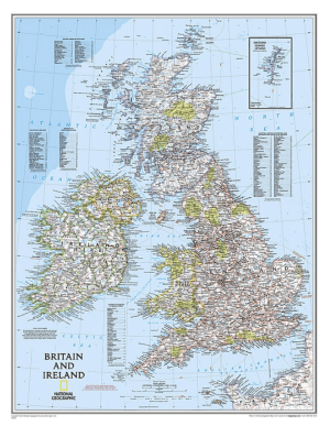
Plano Wandkaart Groot-Brittannië & Ierland 60 x 76 cm - Nat Geo • 9780792250234
Wandkaart Groot-Brittannië & Ierland 60 x 76 cm - Nat Geo Productomschrijving: National Geographic's Classic political map of Britain and Ireland is both an attractive addition to any study or classroom and an informative tool for exploring these fascinating countries. The map features thousands of place names, major highways and roads, airports, ferry routes, bodies of water, and more. Ha…

Fietsgids Great British Gravel Rides - Vertebrate Publ. • 9781839811265
Great British Gravel Rides - Vertebrate Productomschrijving: Cycling the wild trails of England, Scotland & Wales Great British Gravel Rides by Markus Stitz is a collection of 25 routes – each is a favourite of a passionate gravel cyclist – exploring the very best gravel cycling across England, Wales and Scotland. Illustrated with stunning action photography and overview mapping; downl…
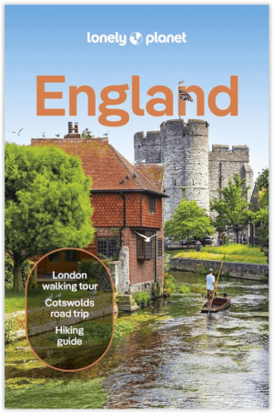
Reisgids England - Lonely Planet • 9781837583447
Travelguide England - Lonely Planet Productomschrijving: This green land, this sceptred isle, this crucible of empire and pioneer of parliamentary democracy, is the most eccentric, extraordinary and downright intriguing place on Earth. Lonely Planet will get you to the heart of England, with amazing travel experiences and the best planning advice. Covers: London, Newcastle, Lake Distri…
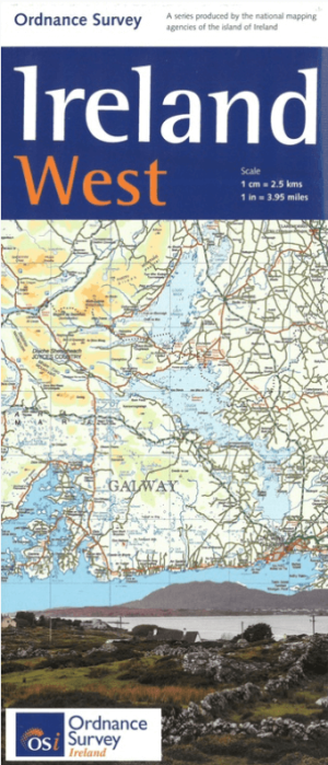
Landkaart Wegenkaart H2 Ierland West - OSI • 9781908852878
Wegenkaart West Ierland - OSI Productomschrijving: Wegenkaart West Ierland - OSI - Ordnance Survey Ireland West Road map at 1:250,000 approx 4 miles to the Inch. This map shows detailed road classification, altitude colouring and tourist information, published by OSI, the Ordnance Survey of Ireland. Topography of the island is shown by altitude colouring, with additional spot …

Reisgids Great Britain - Groot Brittannië - Lonely Planet • 9781837583515
Travelguide Great Britain - Lonely Planet Productomschrijving: Buckingham Palace, Stonehenge, Manchester United, The Beatles – Britain does icons like nowhere else, and travel here is a fascinating mix of famous names and hidden gems. Covers: Planning chapters, London, Canterbury, Southeast England, Oxford, Cotswolds, Southwest England, Cambridge, East Anglia, Birmingham, the Midlands…