

Wandelkaart 13 Achaia Griekenland - Anavasi
Kiato- Aigio- Kato Achaia- Kalavryta- Northwest Peloponnese

Korte omschrijving
Wegenkaart Achaia - Anavasi Productomschrijving: Road map of the region of Achaia in a scale of 1:100 000, with a city plan of central Patras. Achaia or Achaea, sometimes even written Achaia...

Specificaties
- Uitgever: Anavasi Editions
- ISBN-13: 9789608195189
- HOOFDCATEGORIEËN: Wegenkaart - Landkaart
- Activiteiten: Wandelen, Hiking & Trekking
- Regio: Peloponnessos, Griekenland
- Land: Griekenland
- TOPO's & Stafkaarten: Topografisch wandelen
- Schaal: 1:100000
- Taal: Engels
- De Griekse Eilanden: Peloponnesos (Schiereiland)
Volledige omschrijving
Wegenkaart Achaia - Anavasi
Productomschrijving: Road map of the region of Achaia in a scale of 1:100 000, with a city plan of central Patras. Achaia or Achaea, sometimes even written Achaia, is the translitteration in Greek. Achaia is a region in the Northwest of the Peloponnese, though administratively a part of the region of Western Greece, and its capital is Patras, one of the main cities of Greece and a large port on the Gulf of Patras. Other major cities are Kiato, Aigio, Kato Achaia, Kalavryta.
Patras cityscape is dominated by mount Panaichaiko (1926m). Chelmos (2355m) and Erymanthos (2224m) are the highest mountains in Achaia.
Discover touring destinations in Achaia.
*Anavasi makes high standard hiking or touring maps, with accurate cartographic data that compose a detailed background, with coordinates in EGSA87 & WGS84 (displayed on the map) to find your position using your GPS device. The map is printed on polyart, the recyclable synthetic paper to take with you in all your activities.
The map you see here is the result of the cooperation of many people and tries to capture the complexity of the Greek landscape. For maps, as for many other things, views and experiences are endless, different every time and for everyone. This map is the result of bibliographic research as well as field work, made in collaboration with climbers and local alpine clubs.
In each new version of a map we ask ourselves how we could make it better. We imagined new categories of paths, adventure trails, exposed paths and climbing ridges. We added new categories of information such as mountain running races, and mountain skiing routes.
A map not just about the cartography, it is also about our experiences in the field. We share favorite routes and describe the paths in a few words.
There is no final version of a map, the changes in the landscape are continuous and the improvements or information that can be added are inexhaustible. Whether from new data or from the collective experience of the mountaineering community, we aim to add more and more levels of information to the map to capture the dynamic evolution of the landscape, the experiences and knowledge that unfold and the new activities that develop."
Locatie op kaart
Overzichtskaarten
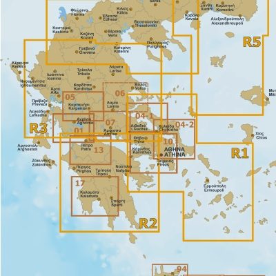
Anavasi wegenkaarten 1 > 17 - 1:100.000 Vasteland Griekenland
Anavasi wegenkaarten 1 > 17 - 1:100.000 Vasteland Griekenland
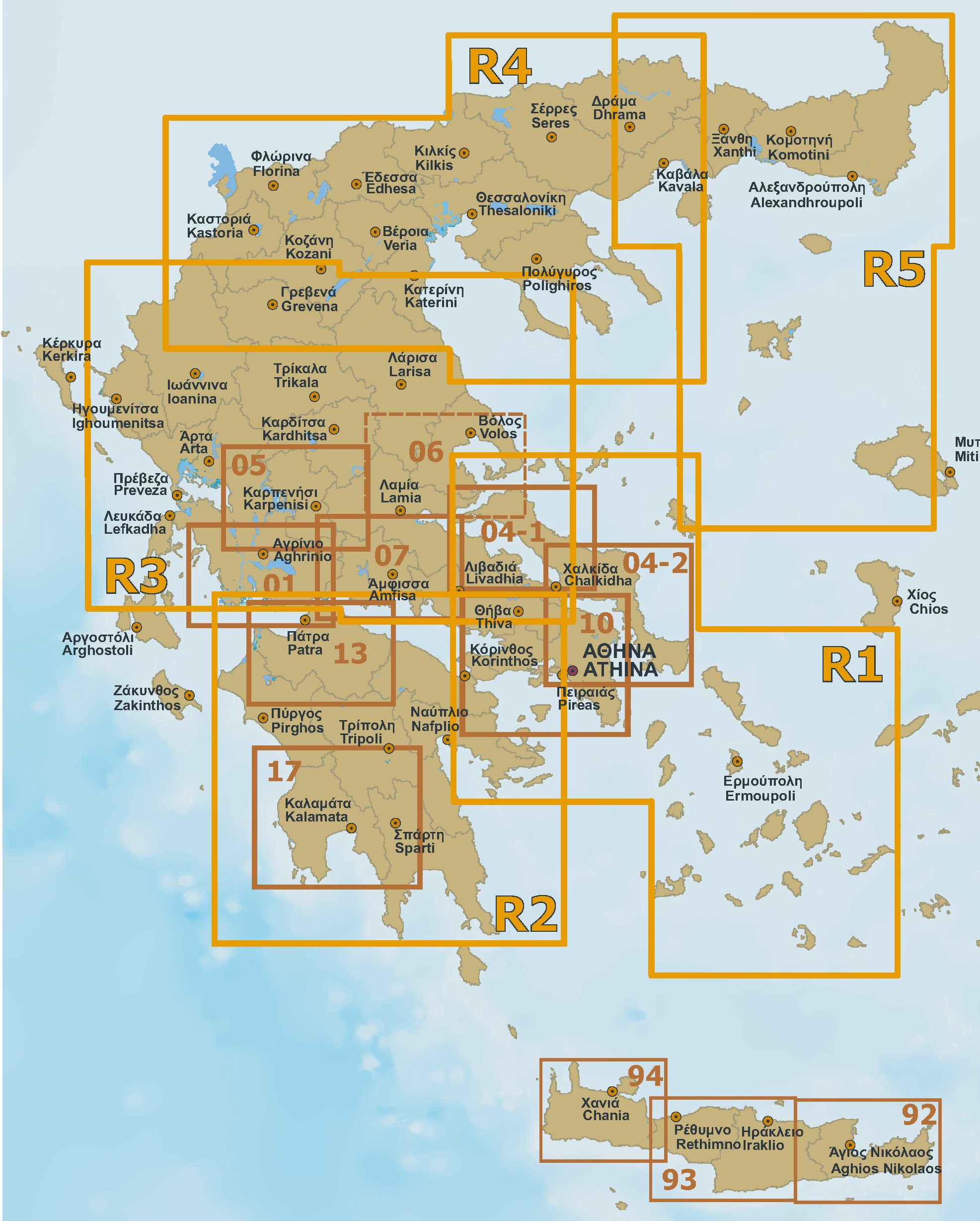
Producten op de overzichtskaart
Klik op een product om naar de detailpagina te gaan.
Artikelen uit dezelfde regio

Wandelgids Peloponnes - Rother • 9783763344468
Wandelgids Peloponnes - Rother - 40 dagtochten Productomschrijving: 40 geselecteerd wandelingen in de Peloponnesos naar afgelegen baaien, oorspronkelijke berg en vissersdorpjes, pieken, adembenemende gorges en oude sites. De Peloponnesos, gelegen in het uiterste zuidoosten van Europa, is een van de meest populaire vakantiebestemmingen in het Middellandse-Zeegebied. Het Griekse schierei…

Reisgids Athene Griekse vasteland & Peloponnesos - Michelin • 9789401498470
Reisgids Groene gids Athene Griekse vasteland - Lannoo Productomschrijving: Groene Reisgids Griekse Vasteland, met Athene-Peloponnesos-Korfoe-Thessaloniki. - Michelin Editions - Haal meer uit uw vakantie met de Michelin-sterren! De serie Groene Reisgidsen van Michelin is een beproefde en betrouwbare reisgidsenreeks. Of u nu lekker lang met vakantie gaat of er zomaar even tussenui…
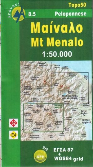
Wandelkaart 8.5 Mt. Menalo Griekenland - Anavasi • 9789608195660
Topografische Wandelkaart 8.5 - Mt. Menalo Griekenland Productomschrijving: Mt. Menalo, is een bergketen dat ongeveer 15 tot 20 km van Noord naar Zuid ten zuidwesten van Tripoli ligt, ten noordoosten van Vytina, en van Oost naar West, 5 tot 10 km van Zygovisti die Kapsas overspant. Veel van het gebied wordt gedekt met oude groeibossen maar de meeste werden verbrand in 2000 en vooral in sep…
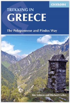
Wandelgids Trekking in Greece - Cicerone • 9781852849689
Trekking in Greece - Cicerone Press Productomschrijving: Nieuwe wandelgids over verschijdene treks/wandelingen in de Griekse bergen in de regio van Peloponese. De routes lopen door de Pindhos Range dicht bij Athene, als ook een paar kleinere dicht bij Mount Olympus. Engelse omschrijving: Guidebook describing challenging treks in the mountains of Greece, traversing the Pindhos Range, ne…

Reisgids Peloponnesos Griekenland - Marco Polo • 9783829758598
Reisgids Peloponnesos - Marco Polo Productomschrijving: Marco Polo reisgids voor de Peloponnesos! Handig pocket formaat, boordevol informatie, met uitneembare kaart van het hele gebied en 6 bladzijden atlas. Proef de sfeer van het oude Griekenland, geniet van de natuur en de prachtige stranden of dwaal rond in pittoreske dorpjes. Met 'insider tips' om de Peloponnesos écht te ontdekken, de…