
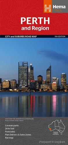
Stadskaart plattegrond Perth & omgeving - Hema Maps
Perth is one of the most isolated cities in the world
Korte omschrijving
Wandelkaarten Perth en Western Australia van Hema Maps. Ideaal voor tochten in Australië.
Stadskaart Perth & omgeving - Hema Productomschrijving: Perth CBD, City & Suburbs Map A map that has the Perth suburbs (1:80,000) and Perth city (1:15,000) maps on one side and the Perth...

Specificaties
- Uitgever: Hema Maps
- ISBN-13: 9781925195163
- HOOFDCATEGORIEËN: Stadskaart plattegrond
- Activiteiten: Street/Road maps & city plans, Toerisme
- Regio: Perth, Western Australia
- Land: Australië
- Schaal: 1:80000
- Editie: 11
- Taal: Engels
Volledige omschrijving
Stadskaart Perth & omgeving - Hema
Productomschrijving: Perth CBD, City & Suburbs Map
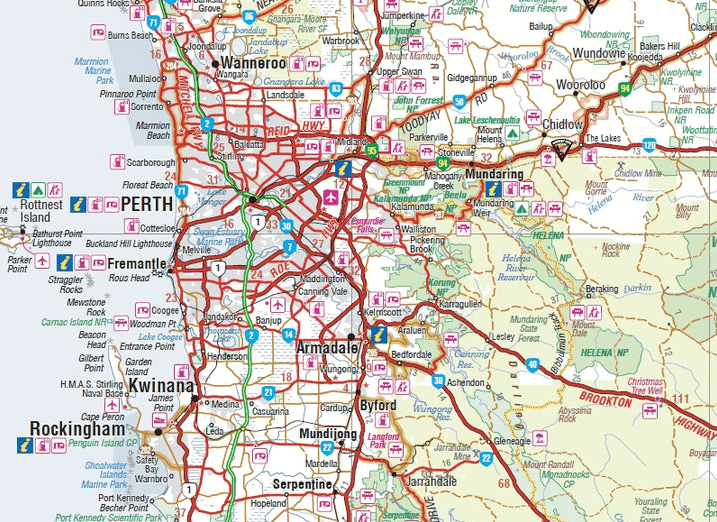
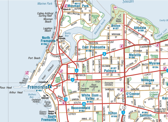
A map that has the Perth suburbs (1:80,000) and Perth city (1:15,000) maps on one side and the Perth region (1:750,000) and Fremantle (1:20,000) maps on the other. Included is a rail network map of Perth as well as points of interest and accommodation for both Fremantle and Perth.
Perth is one of the most isolated cities in the world. Despite its isolation, or because of it, Perth has developed into a dynamic and prosperous city with many diverse attractions for the visitor. Basically, the city is divided in two by the Swan River estuary. For many people, the Swan River is what defines Perth. On any fine weekend the wide waterway teems with yachts, powerboats and paddlers. The walking paths and cycleways that run along its banks are well utilized and families flock to picnic locations in shady parks. Boat cruises take tourists up and down the river, and ones that call in to riverside wineries in Middle Swan are particularly popular. With its superb beaches and location on the banks of the Swan River, it’s little wonder Perth has become famous as an outdoor playground.
The most popular and well known of Perth’s magnificent white beaches are Scarborough and Cottesloe beaches. City Beach and Floreat Beach are other family-oriented beaches while the best waves close to Perth occur at Trigg Beach. The best known and loved park in Perth is undoubtedly Kings Park. It protects a large area of natural bushland and during September, at the height of the wildfl ower season, is a blaze of colour. Jacobs Ladder, a set of nearly 300 steps, rises steeply from the base of Mount Eliza to Kings Park.
At the mouth of the Swan River is bustling Fremantle, a busy port with a lively restaurant, bar and café culture. One highlight is taking a guided tour of the historic convict-built Fremantle prison, which is now a museum. The Hotels and Breweries Walk - an easy 2.5km stroll with plenty of cafes, pubs and restaurants enroute.
Places of interest include:
• Art Gallery of Western Australia
• Barracks Archway
• Cloisters, The
• Deanery, The
• Government House
• Hay Street Mall
• His Majesty's Theatre
• Horseshoe Bridge
• King Street Arts Theatre
• Kings Park
• Kings Park Lookout
• Langley Park
• Murray Street Mall
• NIB Stadium
• Old Council House
• Old Mill
• Old Perth Boys School
• Parliament House
• Perth Arena
• Perth Concert Hall
• Perth Convention Exhibition Centre
• Perth Institute of Contemporary Arts
• Perth Mint
• Perth Town Hall
• Perth Zoo
• St. George's Cathedral
• St. Mary's RC Cathedral
• Scitech Discovery Centre
• State Library of Western Australia
• State War Memorial
• Swan Bells
• Wellington Square
• Western Australia Museum
F remantle places of interest include:
• Army Museum of WA
• Cappuccino Strip
• Captain Cook Cruises
• Duyfken Replica
• E-Shed Markets
• Fremantle Markets
• Fremantle Prison
• Fremantle Tourist Wheel
•Little Creatures Brewery
• Maritime Museum
• Round House
• Shipwreck Galleries
Artikelen uit dezelfde regio

Landkaart Wegenkaart 619 Western Australia State & Cities - UBD • 9780731933198
Wegenkaart Western Australia State & Cities - Gregory's Productomschrijving: The latest edition of the Western Australia State and Cities map has been fully revised and updated. It includes a comprehensive state map with an index to the towns and localities at a scale of 1: 2.900.000 plus more detailed coverage of South West Western Australia at a scale of 1 : 1.870.000 on one side. …
Landkaart Wegenkaart Explorer Map Nullarbor Plain - Western Map • 9781925625981
Explorer Map Nullarbor Plain Western Map - Hema Productomschrijving: This map is part of Hema's new Nullarbor Plain Map Series and covers the area from Kalgoorlie to Border Village and its surrounds. Truly one of the worlds great adventure drives, Australia's semi-arid Nullarbor Plain stretches some 1,256 kilometres (781 miles) via the Eyre Highway and links the cities of Adelaide and…
Reisgids Western Australia - Bradt guides • 9781784777531
Western Australia - Bradt Productomschrijving: Bradt's Western Australia is de eerste gids gericht op de lange landwegen, inspirerende nationale parken en wijngaarden van wereldklasse van Australië's grootste staat. Inwoner Scott Dareff heeft de afgelopen vijf jaar bijna alle 137 administratieve gebieden van de staat bezocht, waardoor hij een buitengewoon inzicht in en kennis van een van '…

Landkaart Wegenkaart West & Midden-Westen Australië NP's - Hema • 9321438002109
Landkaart West & Midden-Westen Australië - Hema Produductomschrijving: A regional map of Mid West Western Australia that covers from Cape Range National Park south to Mandurah and as far as Kalgoorlie at a scale of 1:1,250,000 that has camping areas, national parks, fuel supplies and facility symbols marked on the map. On the reverse is region-specific touring information for Wildflower c…

Kampinggids Perth & The South West 4WD + Camping escapes - Hema • 9781865006215
Wegenatlas Kampinggids Perth & The South West Productomschrijving: 4WD + Camping Escapes – Perth & the South West is a guide to the best four-wheel driving and camping locations in South West Western Australia. Each regional section outlines the area’s 4WD Tracks and Featured Camping Areas, with a Camping Directory at the end to provide comprehensive coverage of other camping areas. T…