

Reisgids Lake District - Top 10 - DK Eyewitness
Quaint villages of Grasmere - Windermere - Kendal


Korte omschrijving
DK Eyewitness TOP 10 Lake District Omvat: Windermere, the Central Fells, Ullswater, the Northwest, Whitehaven & Wasdale. Productomschrijving: Bezoek de schilderachtige dorpjes van Grasme...

Specificaties
- Uitgever: Dorling Kindersley Limited
- ISBN-13: 9780241296288
- HOOFDCATEGORIEËN: Reisgids
- Activiteiten: Toerisme
- Auteur:: Helena Smith
- Regio: Cumbria & Lake District, England
- Land: England
- Nationale parken: Lake District NP, Cumbria England
- Taal: Engels
- Reeks/Serie:: Eyewitness, Dorling Kingsley, TOP 10 - Eyewitness
- Iconische Wandelroutes: Lake district, Cumbria England
Volledige omschrijving
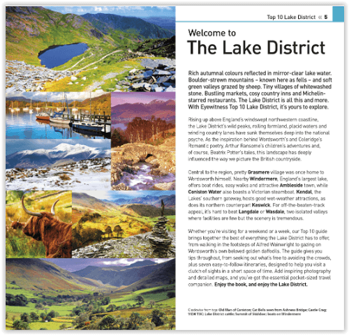
DK Eyewitness TOP 10 Lake District
Omvat: Windermere, the Central Fells, Ullswater, the Northwest, Whitehaven & Wasdale.
Productomschrijving: Bezoek de schilderachtige dorpjes van Grasmere, maak een rondvaart door Windermere, haal munttaart in Kendal of ga wandelen in de vallei van Langdale. Van de Top 10 kastelen en huizen tot de Top 10 pubs en herbergen - ontdek het beste van het Lake District met deze gebruiksvriendelijke reisgids.
Engelse omschrijving: Visit the quaint villages of Grasmere, take a cruise around Windermere, pick up some mint cake in Kendal or go for a hike in the valley at Langdale. From Top 10 castles and houses to the Top 10 pubs and inns - discover the best of the Lake District with this easy-to-use travel guide.
Inside Top 10 Lake District:
- Five easy-to-follow itineraries to help you make the most of your trip
- Top 10 lists showcase the best Lake District attractions, covering Keswick, Coniston Water, Wasdale and more
- Free laminated pull-out map of the Lake District, plus seven colour area maps
- In-depth neighbourhood guides explore the Lake District's most interesting areas, with the best places for eating, hiking and swimming.
- Colour-coded chapters divided by area make it easy to find information quickly and plan your day
- Essential travel tips including our expert choices of where to stay, eat, shop and sightsee, plus useful transport, visa and health information
- Colour maps help you navigate with ease.
Locatie op kaart
Artikelen uit dezelfde regio

Wandelgids The Pennine Way - Trailblazer • 9781912716333
The Pennine Way 420 km - Trailblazer Productomschrijving: De Pennine Way, het bekendste nationale pad van Groot-Brittannië, slingert zich 420 km over woeste heidevelden en door stille dalen langs de ruggengraat van Noord-Engeland. Het begint in Edale in het Peak District en eindigt net over de grens in Schotland bij Kirk Yetholm. Dit prachtige wandelpad doorkruist 3 nationale parken - het …

Wandelkaart Lake District South-East XT40 - Harvey Maps • 9781851376667
Wandelkaart Lake District Zuid-Oost XT40 - Harvey Maps Productomschrijving: Omvat een groot gebied maar is praktisch en compact, zakformaat. Gedetailleerde kaart voor lopers en wandelaars van de zuidoostelijke heuvels van het Lake District National Park. Op de kaart staat Lake Windermere in het midden. Inclusief Ambleside, Coniston en Kendal en het uitstekende mountainbikegebied van G…

Lake District Great mountain days - Lakeland Fells - Cicerone • 9781852845162
Lake District- Great mountain days - Lakeland Fells - Cicerone Productomschrijving: Een inspirerende gids voor 50 uitdagende wandelingen op de hoge bergen van het Lake District. De gesorteerde cirkelvormige routes, tussen de 4 en 14 mijl in lengte, bedekt klassieke Lakeland toppen zoals Fairfield, Scafell Pike, Great Gable en Blencathra, op de minder bekende Hoge Spy -, King's How en Brund…
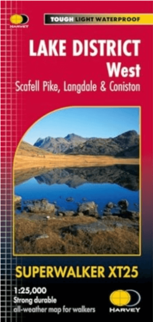
Wandelkaart XT25 Lake District West - Harvey Maps • 9781851376919
Wandelkaart Lake District West - Harvey Maps Productomschrijving: Scafell en The Langdale Pikes, en de bergen ten westen van de Kendal-Keswick-weg. - Gedetailleerde kaart voor bergwandelaars van de uitdagende westelijke bergen van The Lake District National Park. - Hard Knott en Wrynose passen. Ennerdale, Wast Water en Coniston Water. - Inclusief 74 bergtoppen beschreven door A. Wa…

Wandelgids Coast to Coast path - Trailblazer • 9781912716258
Coast to Coast path 370 km - Trailblazer Productomschrijving: 109 kaarten, 14 etappe kaarten en 60 kleurfoto's van één van Engeland's mooiste wandelroutes, en tevens meest gekend. Het Coast to Coast Pad is een pad van 307 km dat loopt van St Bees aan de Ierse Zee over de breedte van Noord-Engeland naar de Noordzee bij Robin Hood's Bay. Deze spectaculaire wandeling van twee weken doorkruist…