

Landkaart Wegenkaart 43 South East Queensland - UBD Gregory's
Murgon- Gympie- Double Island Point- Tenterfield- Evans Head
Korte omschrijving
Wegenkaart South East Queensland - UBD Gregory's Productomschrijving: The latest edition of the South Eastern Queensland map has been fully revised and updated and includes regional coverag...

Specificaties
- Uitgever: UBD Gregory's Universal Publishers
- ISBN-13: 9780731932924
- HOOFDCATEGORIEËN: Wegenkaart - Landkaart
- Activiteiten: Street/Road maps & city plans
- Regio: Queensland, Noord-Oost Australië
- Land: Australië
- Schaal: 1:500000
- Editie: 9
- Taal: Engels
- De Australische Regio's: Queensland
Volledige omschrijving
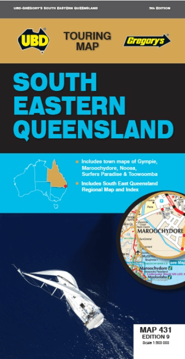
Wegenkaart South East Queensland - UBD Gregory's
Productomschrijving: The latest edition of the South Eastern Queensland map has been fully revised and updated and includes regional coverage from Murgon, Gympie and Double Island Point in the north, Tenterfield and Evans Head (NSW) in the south, Columboola in the west and east along the coast from Double Island Point to Evans Head. There is also an index to towns included on this coverage.
There is also a smaller regional map at a scale of 1: 2 600 000 indicating the location of the towns and covering from Brovinia in the north, Deepwater (NSW) in the south and east along the coast from Rainbow Beach in the north to Bundjalung National Park (NSW) in the south & west to Glenmorgan.
Also included are street level maps at a scale at 1:20.000 for: the Gympie area including Araluen and Southside; Maroochydore and the surrounding suburbs including Buderim and Alexandra Headland; the Noosa area including the suburbs of Tewantin and Sunrise Beach. There is also a street level map of Surfers Paradise from Main Beach in the north to Broadbeach in the south (at a scale of 1: 15 000), plus a map of Toowoomba town centre at a scale of 1 : 10 000.
This conveniently sized map is packed with information and is an essential tool when travelling around South Eastern Queensland.
Artikelen uit dezelfde regio
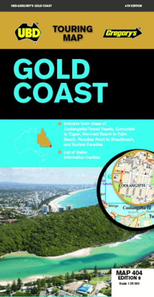
Landkaart Wegenkaart 404 Gold Coast Queensland - UBD Gregory's • 9780731932023
Wegenkaart Gold Coast Queensland - UBD Gregory's Productomschrijving: Gold Coast region map at a scale of 1 : 160 000 covering along the coast from South Stradbroke Island in the north to Bogangar NSW in the south & Beaudesert in the west, Beenleigh in the north & Murwillumbah NSW in the south. - Region map at a scale of 1 : 450 000 covering along the coast from Sandgate in the north t…

Wegenatlas Cape York Atlas & Guide - Hema Maps • 9781876413439
Wegenatlas Cape York Atlas & Guide - Hema Productomschrijving: Hema Maps’ Cape York Atlas & Guide helps you make the most of your visit to this remarkable part of Australia. With detailed coverage of The Tip, the coast from the Cairns region to Cooktown, Rinyirru (Lakefield) National Park, the Peninsula Developmental Road, Old Telegraph Track, Torres Strait and the Savannah Way, it en…

Landkaart Wegenkaart Brisbane tot Cairns Region - Hema Maps • 9781865008714
Wegenkaart Brisbane tot Cairns Region - Hema Productomschrijving: City to City Map - via the Bruce Highway A Brisbane to the Cairns Region map at a scale of 1:1,500,000 with tourist drives map (1:3,000,000). Drive between Brisbane to Cairns with relevant touring points of interest and detailed mapping for the trip with 24-hour fuel, camping areas and caravan parks, rest areas and attra…

Landkaart Wegenkaart Great Desert Tracks Simpson Desert - Hema • 9781922668073
Wegenkaart Great Desert Tracks Simpson Desert - Hema Productomschrijving: Great Desert Tracks Simpson Desert (9th edition) - discover the Simpson Desert with detailed mapping, relevant points of interest and essential touring information for the journey. Hema's Great Desert Tracks maps are essential for anyone travelling in the Australian outback. The mapping features roads and 4WD tr…
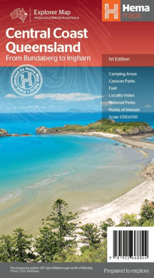
Landkaart Wegenkaart Explorer Map Central Coast Queensland - Hema • 9781922668844
Explorer Map Central Coast Queensland - Hema Productomschrijving: Central Coast Queensland Map (1st edition) - a two-sided regional map of the Central Coast of Queensland (1:550,000) that stretches from just south of Bundaberg up to Ingham in the north and as far west as Clermont. This two-sided regional map showcases the Central Coast of Queensland (1:550,000), extending from just so…