

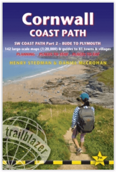
Wandelgids DEEL 2 Coast Path Bude to Plymoith - Trailblazer
SWCP 2 - From Bude to Plymouth in Cornwall and Devon
Korte omschrijving
Wandelgidsen Cornwall, England van Trailblazer Publications. Ideaal voor tochten in England.
Wandelgids DEEL 2 - Bude to Plymoith - Trailblazer Productomschrijving: Cornwall Coast Path (South-West Coast Path Part 2 - SWCP 2) - Deze gids voor het kustpad van Bude naar Plymouth (288¼ ...

Specificaties
- Uitgever: Trailblazer Publications
- ISBN-13: 9781912716265
- HOOFDCATEGORIEËN: Wandelgids
- Activiteiten: Wandelen, Hiking & Trekking
- Regio: Cornwall, England
- Land: England
- Lange afstand wandelroutes: South West Coast Path - SWCP (1014 km)
- Editie: 7
- Taal: Engels
- Iconische Wandelroutes: Coast to coast path, UK
- National Trails UK, England & Wales: Coast to Coast Walk, England
Volledige omschrijving
Wandelgids DEEL 2 - Bude to Plymoith - Trailblazer
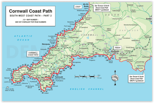
Productomschrijving: Cornwall Coast Path (South-West Coast Path Part 2 - SWCP 2) - Deze gids voor het kustpad van Bude naar Plymouth (288¼ mijl - 460 km) beslaat het tweede deel, Cornwall, van het 630 mijl (1014 km) lange South-West Coast Path.
Dit is een van de beste kustwandelingen in Europa. Het wandelpad voert langs kleine vissersdorpjes, rotsachtige landtongen, bruisende badplaatsen, beboste riviermondingen en gouden, door de branding omzoomde stranden. Het is een gebied dat rijk is aan wilde dieren, met zeevogels, wilde bloemen, dolfijnen en zeehonden. Het pad is volledig opnieuw bewandeld en alle informatie is gecontroleerd voor de nieuwe 5e editie.
Engelse omschrijving: Cornwall Coast Path (South-West Coast Path Part 2 - SWCP 2) - This guide to the coast path from Bude to Plymouth (288¼ miles - 460km) covers the second section, Cornwall, of the 630-mile (1014km) South-West Coast Path.
This is some of the best coastal walking in Europe. The footpath takes in tiny fishing villages, rocky headlands, bustling resorts, wooded estuaries and golden surf-washed beaches. It is an area rich in wildlife, with seabirds, wild flowers, dolphins and seals. The path has been completely rewalked and all the information checked for the new 5th edition.
- Bude to Plymouth - 142 detailed walking maps & town plans- 30 colour photos & colour flower and bird sections
- 120mm x 180mm, 5" x7" - Includes 142 detailed walking maps: the largest-scale maps available - Unique mapping features
- Itineraries for all walkers
- Detailed public transport information for all access points
- Practical information for all budgets
Locatie op kaart
Artikelen uit dezelfde regio

Wandelgids 005 Pathfinder guides Cornwall England - OS • 9780319090299
Wandelgids Cornwall England - OS Productomschrijving: Pathfinder(R) Cornwall covering Land's End, Prussia Cove and Bodmin Moor. This selection offers interest, regional variety and balance of routes in Cornwall providing the best walks in the area. From an easy stroll along Falmouth Bay to the much more challenging walks along Looe Bar this volume contains something for everyone. Cover…

Wandelgids DEEL 1 Coast Path Exmoor & North Devon - Trailblazer • 9781912716241
Wandelgids DEEL 1 - Exmoor & North Devon Coast Path Productomschrijving: Exmoor & North Devon kustpad (South-West Coast Path Deel 1) Minehead naar Bude. Deze gids omvat het eerste deel van het South West Coast Path, van Minehead naar Bude (124,5 mijl). Deze spectaculaire 10- tot 12-daagse route loopt door het Exmoor National Park langs de hoogste kustlijn van Engeland (meer dan 800…
Wandelkaart 101 Isles of Scilly- SW England - OSI • 9780319243039
Wandelkaart Isles of Scilly - SW England - Ordnance Servey. Productomschrijving: Isles of Scilly, South West England - Kaart nummer 101 is een all purpose kaart vol gepakt met informatie om u het gebied te helpen leren kennen. De 204 Landranger-kaarten bestrijken het land. Elke kaart heeft een oppervlakte van 40 km door 40 km (25 mijl door 25 mijl) en zoals andere kaarten van Ordnance Surv…

Wandelgids Cornwall- Newquay & The North Coast - Cicerone • 9781786312471
Wandelgids Cornwall- Newquay & The North Coast Productomschrijving: Would you like to explore the best of Newquay and the North Coast? This guidebook covers 15 of the best short walks in the area (between 3 and 9.6km, all under three hours), including Polly Joke, Watergate Bay, Trevose Head, Padstow, Port Isaac, Camelford and Boscastle. Why choose this guidebook? - Easy to moderat…
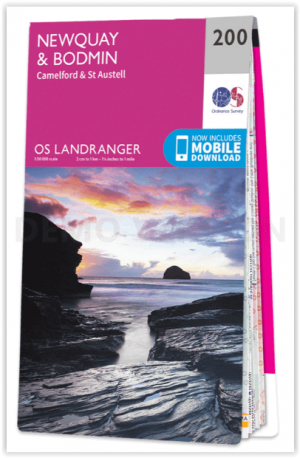
Wandelkaart 200 Newquay- Bodmin & Camelford - OSI • 9780319475799
Wandelkaart Newquay- Bodmin & Camelford Cornwall Productomschrijving: Kaart nummer 200 in de OS Landranger kaartenserie is de perfecte kaart voor het plannen van dagjes uit en rondreizen in de gebieden Newquay, Bodmin, Camelford en St Austell in Cornwall. Newquay en omgeving is beroemd om zijn surfstranden en is een geliefde vakantiebestemming. Hoogtepunten van het gebied zijn: Padstow…