

Stadsplattegrond Dublin street map - Ordnance Survey
A large double-sided street plan od Dublin Ireland

Korte omschrijving
Stadskaart Dublin street map - Ordnance Survey Productomschrijving: This map is a large, double-sided street plan from the Ordnance Survey of Ireland covering the city beyond its motorway r...

Specificaties
- Uitgever: Ordnance Survey Ireland
- ISBN-13: 9781912140657
- HOOFDCATEGORIEËN: Stadskaart plattegrond
- Activiteiten: Street/Road maps & city plans
- Regio: Dublin, Ierland
- Land: Ierland
- Schaal: 1:20000
- Editie: 20
- Taal: Engels
Volledige omschrijving
Stadskaart Dublin street map - Ordnance Survey
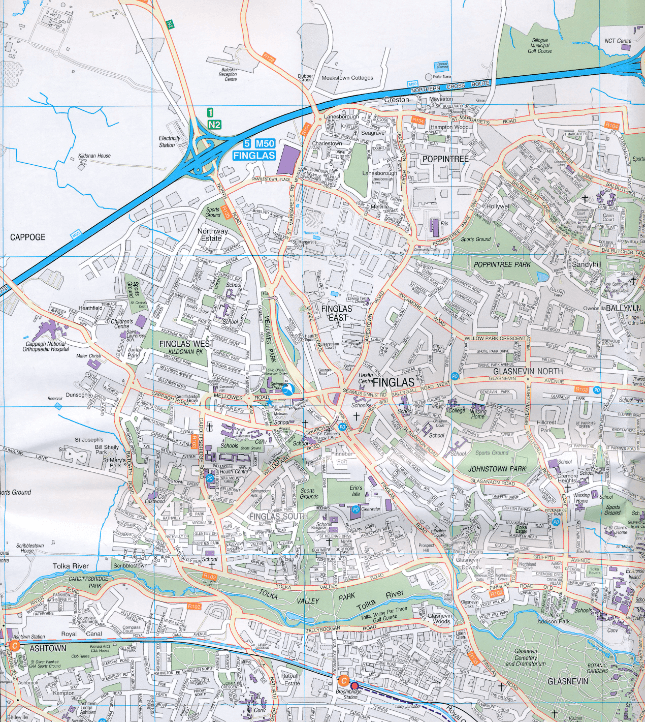
Productomschrijving: This map is a large, double-sided street plan from the Ordnance Survey of Ireland covering the city beyond its motorway ring, with an enlargement showing the centre in greater detail, plus an index in a separate booklet. The map is double-sided, dividing Dublin east/west with a good overlap between the sides, and provides coverage roughly within the M50 motorway ring, plus well beyond it in the west.
Main traffic routes are highlighted and the map also shows the Garda speed enforcements zones;
- The map indicates one way streets on the city centre enlargement. - Luas lines are shown with stops and railway stations are clearly marked. - The map also shows the dublinbikes stations. - Important buildings are prominently indicated by colours and symbols show various public facilities. - The index grid divides the city into 1-km squares: the index is in a separate booklet. - The plan also includes an enlargement showing the city centre in greater detail at a scale of 1:7,500, with more prominent colouring.Artikelen uit dezelfde regio
Reisgids Dublin - Mini Rough Guides • 9781835291641
Op reis naar Dublin - Mini Rough Guides Productomschrijving: This Mini Rough Guide to Dublin covers: Grafton Street and around; Old Dublin; Georgian Dublin; North of the river; Excursions around the city in County Dublin In this travel guide you will find: RECOMMENDATIONS FOR EVERY TYPE OF TRAVELLER Experiences selected for every kind of trip to Dublin, from cultural explorations…

Stadsgids Dublin official city & district street guide - OSI • 9781908852847
Dublin official city & district street guide - OSI Productomschrijving: Dublin City and District Street Guide features include schematic maps of all major motorway junctions, and enlarged city centre map and 12 major town maps. Updated information and indexed lists of Hospitals, Embassies and Industrial Estates. Transport information for all main Bus and Rail routes. - Enlarged city c…
Reisgids Wat & Hoe Dublin en Ierland - Kosmos Uitgeverij • 9789043944205
Reisgids Dublin en Ierland - Kosmos Uitgeverij Productomschrijving: Met deze Wat & Hoe Reisgids Dublin & Ierland ga je voorbereid onderweg. Bezoek de prachtige bibliotheek van Trinity College of de National Gallery of Art in Dublin, en besluit je dag in deze bruisende hoofdstad in een van de pubs in Temple Bar. Ierland is het land van groene heuvels, historische schatten en adembenemende …

Wandelkaart 43 County Dublin, County Louth & County Meath - OSI • 9781912140190
Wandelkaart Dublin, County Louth & County Meath - OSI Productomschrijving: Ontdek Ierland met de Discovery Series Wandelkaarten van Ordnance Survey Ireland. De Discovery Series wandelkaarten van Ordnance Survey Ireland (OSi) zijn dé keuze voor wandelaars, fietsers en avonturiers die Ierland echt willen verkennen. Deze hoogwaardige topografische kaarten bieden een gedetailleerd en nauw…

Reisgids Week-end Dublin - Michelin • 9789401498449
Reisgids Week-end Dublin - Michelin Productomschrijving: Klein in formaat, groot in kwaliteit - De ideale gids voor wie slechts één compacte stadsgids in zijn tas wil stoppen en toch geen enkele bezienswaardigheid of topadres wil missen - Met een uitneembare stadsplattegrond - Elk hoofdstuk heeft zijn eigen kleur, zo vindt u feilloos de informatie die u zoekt