Fietsgids Cycling London to Paris - Cicerone
Gloednieuwe fietsgids over de London to Paris Bike Ride
Korte omschrijving
Cycling London to Paris - Cicerone Press Productomschrijving: Gloednieuwe fietsgids over de London to Paris Bike Ride, inclusief de 500 km traditionele route, die gebruik maakt van fietspade...

Specificaties
- Uitgever: CICERONE Press
- ISBN-13: 9781852849146
- HOOFDCATEGORIEËN: Fietsgids
- Activiteiten: Fietsen / VTT / MTB
- Auteur:: Mike Wells
- Regio: Haute-Normandie, Frankrijk, South & South East England, Île-de-France
- Land: England, Frankrijk
- Departement: Eure (27), Oise (60), Pas-de-Calais (62), Seine-Maritime 76, Somme (80)
- Editie: 1
- Taal: Engels
- Fietsen: Fietsen in het Buitenland
Volledige omschrijving
Cycling London to Paris - Cicerone Press
Productomschrijving: Gloednieuwe fietsgids over de London to Paris Bike Ride, inclusief de 500 km traditionele route, die gebruik maakt van fietspaden en rustige wegen plus een ferry overtocht vanuit Dover, en de 400 km Avenue Verte, een bewegwijzerde route via Newhaven/Dieppe die meer gebruik maakt van speciale fietspaden. Elke route duurt 5-7 dagen en ze kunnen gecombineerd worden voor een rondreis.
Engelse omschrijving: Guidebook to the London to Paris Bike Ride, including both the 500km traditional route, which makes use of cycle tracks and quiet roads plus a ferry crossing from Dover, and the 400km Avenue Verte, a waymarked route via Newhaven/Dieppe which makes greater use of dedicated cycle paths. Each takes 5-7 days and they can be combined for a round trip.
Seasons:
Both routes can be cycled at any time of year, though April-October is the best period. Off-road sections of Stages 2 (Pilgrims' Way) and 8 (Coulée Verte) of the classic route are best done after a period of dry weather.
Centres:
The classic route passes through London, Rochester, Ashford, Folkestone, Dover, Calais, Desvres, Hesdin, Abbeville, Amiens, Beauvais, Chantilly and Paris. The Avenue Verte passes through London, Crawley, East Grinstead, Newhaven, Dieppe, Gournay-en-Bray, Gisors, Cergy and Paris.
Difficulty:
Both routes are straightforward, with gently rolling hills and a few short ascents (the maximum altitude reached is only 204m). City street riding in London and Paris can be avoided by using trains to reach the edge of town. Much of the route follows dedicated off-road cycle tracks along old railway track-beds and canal/river towpaths. Where roads are used, these are mostly quiet country lanes or suburban streets. Mainly asphalt or compacted gravel surfaces in good condition, suitable for hybrid or touring cycles. Off-road options in Stages 2 and 8 of the classic route are suitable for mountain bikes at all times and hybrids or tourers in dry weather.
Must See:
The two cities of London and Paris, with their many tourist sights, cultural offerings and gastronomic opportunities, the maritime centre of Greenwich, the North Downs with the Pilgrims' Way and White Cliffs of Dover, the Wealden landscape of Sussex and Kent (England) and the Bray (France), the medieval French towns of Calais, Hesdin, Montreuil, Abbeville and Gisors, the Somme and Oise valleys, the cathedral cities of Rochester, Amiens and Beauvais, the chateau of Chantilly & the limestone plateau of the Vexin.

Artikelen uit dezelfde regio

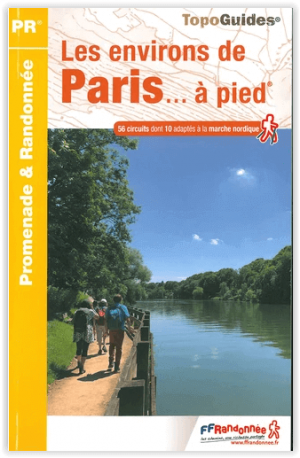
Wandelgids 834 - Les environs de Paris à pied - FFR • 9782751411007
Wandelgids 834 - Les environs de Paris à pied Productomschrijving: Aan de poorten van de hoofdstad, 52 wandelingen verspreid over het hele grondgebied. Wandelingen verfraaid met culturele rijkdom beschermd door natuurparken, evenals door de vele kastelen en abdijen die centraal zullen staan tijdens deze wandelingen. Een verademing en een zuurstoftank die als gezin in één dag kan worden ve…

Wandelgids D091 Essonne à pied - FFR • 9782751411410
Wandelgids Essonne à pied - FFR Productomschrijving: Volledige revisie met 40 nieuwe PR® - Essonne, een groene long in het zuiden van Ile-de-France, is verdeeld tussen de Franse Brie, Gâtinais, Hurepois en Beauce Etampoise. Het landschap bestaat uit beboste of gecultiveerde plateaus die doorsneden worden door een twaalftal rivieren die in noordelijke richting stromen. Deze vredige waterweg…

Wandelgids Pays d'Auge - Suisse Normande à pied - Ed. Chamina • 9782844663962
Wandelgids - Pays d'Auge - Suisse Normande à pied - Ed. Chamina Productomschrijving: Pays d'Auge en Suisse normande vormen het deel ten oosten van het departement van de Calvados. De gids behandelt zowel de kust als de binnenkant van het land rond Honfleur, Cabourg en Lisieux Cliff. De kloven van de Orne regio heet Suisse normande vanwege zijn heuvelachtige omgeving en groen, het is een pa…

Wandelkaart Fietskaart TOP100 D75E Ile-de-France - IGN • 9782758556718
Wandelkaart Fietskaart Ile-de-France - IGN Productomschrijving: Cette nouvelle édition possède un nouveau découpage départemental. Elle intègre les parcours vélo en partenariat avec l'association AF3V – VéloRoutes et Voies Vertes. La nouvelle TOP 100 grâce à son échelle au 1:100 000ème (1 cm = 1 km) est la carte idéale pour découvrir une région et faire du tourisme à pied, à vélo ou en vo…

Wandelkaart 2012 OT - Forêt de Bord-Louviers & Elbeuf - IGN • 9782758541486
TOPO Wandelkaart Forêt de Bord-Louviers & Elbeuf Productbeschrijving: Het regionaal park van Bord-Louviers is een bos van 4.568 Ha gelegen in de Eure, nabij de samenvloeiing van de Eure en de Seine .Deze topografische kaarten met zeer nauwkeurige details, beschikken over informaties kanalen over alle trail, met de aanduideling van onder meer: boom, rivier, bron... Niet te vergeten de verte…


