
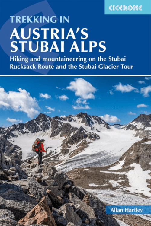
Wandelgids Trekking in the Stubaier Alps - Cicerone
Stubai Rucksack Route & Stubai Glacier Tour

Korte omschrijving
Wandelgidsen Tirol van CICERONE Press. Ideaal voor tochten in Oostenrijk.
Trekking in the Stubaier Alps - Cicerone Productomschrijving: Of all the many Alpine areas, few can match the Stubai Alps in the Austrian Province of Tyrol. With shapely peaks, good paths an...

Specificaties
- Uitgever: CICERONE Press
- ISBN-13: 9781786310651
- HOOFDCATEGORIEËN: Wandelgids
- Activiteiten: Wandelen, Hiking & Trekking
- Auteur: Allan Hartley
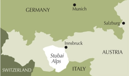
- Regio: Tirol
- Land: Oostenrijk
- Editie: 4
- Taal: Engels
- Iconische Bergketens van Europa: Stubaïer Alpen, Oostenrijk
- Iconische Wandelroutes: Stubaier Högeweg, Oostenrijk
Volledige omschrijving
Trekking in the Stubaier Alps - Cicerone
Productomschrijving: Of all the many Alpine areas, few can match the Stubai Alps in the Austrian Province of Tyrol. With shapely peaks, good paths and some of the best huts in the Alps, it offers ideal hiking routes for mountain walkers. Trekking in the Stubai Alps offers two brilliant routes for the experienced walker: the Rucksack Route and Glacier Tour, both of which fit easily in a two week holiday.
The Rucksack Route:
This 9 to 11 day route links eight huts each with connections directly to the main Stubaital valley, with the exception of one, which means it’s possible to start or end the route according to your preference and can be done in either a clockwise or anticlockwise direction.
Its complete traverse is possible without crossing glaciers or difficult passes which makes the route ideal for mountain walkers, families and others with limited alpine experience. However that is not to say you will not encounter snow, steep ground or the odd scramble here and there. The guidebook also recommends several summits that are attainable along this route for those with sufficient experience.
The Stubai Glacier Route:
This 7 to 8 day route, also known as the Hoehen Weg, involves a lot of glacier work. It is essential that you have the necessary skills to deal with a great variety of terrain that will be crossed. Familiarity with the use of equipment such as ice axes and crampons as well as having good knowledge and experience on crevasses and rope management is essential.
Nevertheless this is a fantastic multi-day route which is ideal for climbers visiting the Alps for the first time as long as they have done the necessary preparation. This is also a hut to hut tour yet instead of avoiding the glaciers as in the first route, the very essence of this tour is to traverse the them. It will suit aspirant alpinists wanting to add to their alpine experience without feeling over-committed and out of their depth.


Artikelen uit dezelfde regio

Fietskaart 7041 tschradweg - Kompass • 9783991542223
Fietskaart Etschradweg - Kompas Productomschrijving: De Etschradweg of Etschfietsroute loopt van Landeck via Meran naar Verona De KOMPASS-fietskaartenserie heeft volgende overtuigende eigenschappen: - duidelijke cartografie op een schaal van 1: 50.000 - gedetailleerde informatie over de wegsoort, de verkeersdrukte en de hellingsgraad - tips voor fietsvriendelijke horeca, treinsta…

Wandelkaart Tannheimer Tal Oostenrijk - F&B • 9783707914757
Wandelkaart WK5352 - Tannheimer Tal Oostenrijk Productomschrijving: Wandelkaart van het Tannheimer Tal te Oostenrijk, waar fietsroutes, wandelroutes en vrije-tijds info zijn op aangetekend. Deze kaarten van Freytag & Berndt, zijn kwalitatief in hun sectie, en duurzaam gemaakt. Hierop vindt u wat u zoekt. Deze kaarten zijn ook geschikt voor GPS coördinatie. Een kaart zeker geschikt voor di…

Wandelkaart 1159 Ischgk Tyrol Oostenrijk - Swisstopo • 9783302011592
Wandelkaart Ischgk - Tyrol Oostenrijk - Swisstopo Productomschrijving: Kaart 1159 - Aanpalend aan het Galteiswald, Aschgl is een skigebied met een serieuze uitgebreide routenetwerk - Ischgl is een gemeente in het district Landeck van de Oostenrijkse deelstaat Tirol. Detail: Zeer gedetailleerde topografische kaarten & wandelkaarten van een klein stuke Zwitserland met schaal 1:25.000.en …
Bergwandelgids 2026 BergWelten: Großvenediger - Tyrolia • 9783702243203
Berg 2026 BergWelten: Großvenediger - Tyrola Productomschrijving: Het boek voor alle bergfanaten - De 150e jubileumeditie van de reeks, waarvan jaarlijks ongeveer 20.000 exemplaren worden verkocht! De ongelooflijke 150e editie van het jaarboek van de Alpenvereniging is er! In 1865, toen het eerste deel verscheen, kwam er net een einde aan de kleine ijstijd. Vandaag de dag belichamen de sne…

Wandelkaart 181 Kals & Matrei - Freytag & Berndt • 9783707923445
Wandelkaart Kals am Großglockner & Matrei - F&B Productomschrijving: De wandelkaarten van Freytag & Berndt zijn de perfecte metgezel voor wandelen, bergbeklimmen en langlaufen, door middel van gedetailleerde digitale kaarten en specifieke criteria. Ze worden regelmatig bijgewerkt en bevatten up-to-date informatie over wandelpaden, fietspaden en mountainbikeroutes, hutten, natuurlijke monum…