

Wandelgids Classic Day Walks in the Peak District - Vertebrate
20 classic circular routes 13km to 19.5 km

Korte omschrijving
Wandelgidsen Derbyshire & Peak District, England van Vertebrate Publishing. Ideaal voor tochten in England.
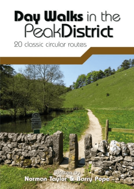
Classic Day Walks in the Peak District - Vertebrate Productomschrijving: Day Walks in the Peak District – 20 classic circular routes features 20 circular walks, between 8.1 and 12.1 miles (1...

Specificaties
- Uitgever: Vertebrate Publishing
- ISBN-13: 9781906148492
- HOOFDCATEGORIEËN: Wandelgids
- Activiteiten: Wandelen, Hiking & Trekking
- Auteur: Barry Pope, Norman Taylor
- Regio: Derbyshire & Peak District, England
- Land: England
- Nationale parken: Peak District NP, Derbyshire UK
- Taal: Engels
- Reeks/Serie: Day walks in, vertebrate Publishing
- De Nationale Parken: Peak District Nationaal Park, England
- De Engelse Graafschappen: Derbyshire, South Yorkshire
Volledige omschrijving
Classic Day Walks in the Peak District - Vertebrate
Productomschrijving: Day Walks in the Peak District – 20 classic circular routes features 20 circular walks, between 8.1 and 12.1 miles (13km and 19.5km), suitable for hillwalkers of all abilities. Local authors Norman Taylor and Barry Pope share walks in their favourite areas of the Peak District National Park including Chatsworth, Chee Dale and Kinder Scout.
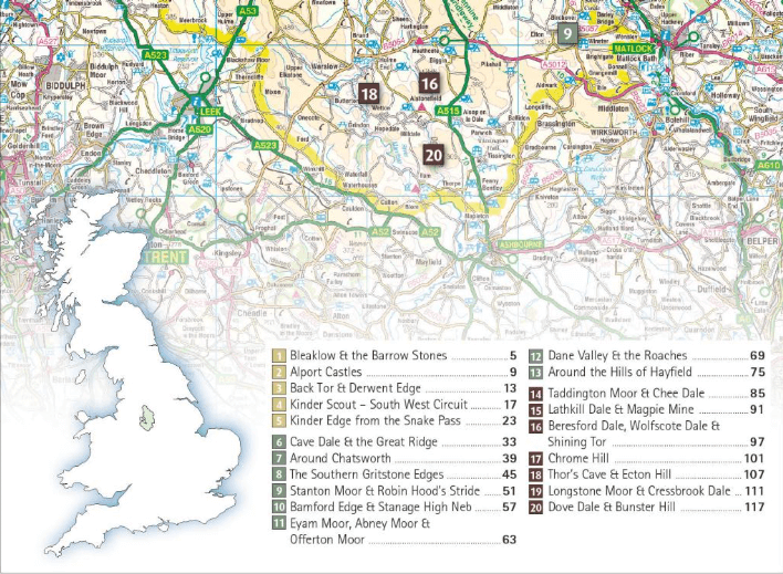
The routes are split into three areas – The High Moors, Hills Tors and Edges and Limestone Country – and feature walks around some of the most wild and beautiful places in the Peak District National Park, including; Alport Castles, Back Tor and Derwent Edge, the Monsal Trail through Chee Dale, the Kinder Edges, Chatsworth, Stanage Moor, The Roaches, Lathkill Dale, Chrome Hill, Cressbrook Dale, Wolfscote Dale and Dove Dale. Researched and written by local hillwalkers, Norman Taylor and Barry Pope, each route features clear and easy to use Ordnance Survey maps, easy-to-follow directions, details of distance, navigation information, refreshment stops and local knowledge. The book is illustrated with stunning location photography, and also features a detailed Appendix.
Artikelen uit dezelfde regio
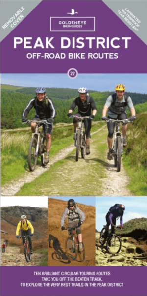
Mountainbike kaart Peak District National Park - Goldeneye • 9781859653012
MTB-kaart Peak District National Park - Goldeneye Productomschrijving: The Peak District National Park is a remarkable place - from the north, the upturned horseshoe of high, gritstone moors and crags of the Dark Peak extend southwards to the east and west of the contrasting limestone plateau of the softer pastoral landscape of the White Peak itself incised by the valleys of the Derbyshir…

Mountainbikegids Gravel Rides Peak District - Vertebrate Publ. • 9781839812316
Gravel Rides Peak District - Vertebrate Productomschrijving: 15 gravel bike adventures in the Dark & White Peak Gravel Rides Peak District by Hetty Kingston showcases 15 of the best gravel bike rides in the stunning Peak District National Park. From 18.3 to 60.8 kilometres in length (plus a 105-kilometre bonus route) and covering a variety of terrain, there is something for every grave…

Wandelgids 073 Pathfinder guides More Peak District - OS • 9780319091081
Wandelgids More Peak District - OS Productomschrijving: This companion to the Pathfinder Peak District Guidebook contains 28 additional circular walks of 5km (3 miles) to 17km (10.5 miles). Like the main book, each is graded by length difficulty, and ranges from relatively easy strolls to some of the more challenging routes with considerable vertical ascent. Each route includes a deta…

Wandelgids Peak District - 50 walks guide - AA Publishing • 9780749583262
Peak District - 50 walks guide - AA Publishing Productomschrijving: Wandelen is een van de favoriete vrijetijdsbestedingen van Groot-Brittannië. Deze AA gids - 50 wandelingen in het Peak District, bevat een verscheidenheid aan uitgestippelde wandelingen van twee tot tien mijl, geschikt voor alle niveaus. Het boek bevat alle praktische details die je nodig hebt, vergezeld van fascinerende a…

Reisgids Go Slow Peak District National Park - Bradt travel guides • 9781804692509
Reisgids Peak District National Park - Bradt Productomschrijving: This new, thoroughly updated edition of Bradt's Slow Travel Peak District brings a fresh perspective to this much-loved area. Slow down and let expert local author Helen Moat guide you to not just all the well-known places, but away from the crowds to uncover the hidden corners of the Peak District. The author's love of int…